
Station XO KD04 - Santa Flavia Bay, AK
Network: XO18 - AACE: Alaska Amphibious Community seismic Experimen
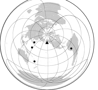
Nearby stations (2 deg radius)

| Station | Name | (Lat, Lon) | Start / End | Elevation |
| KD04 | Santa Flavia Bay, AK | (57.30, -152.85) | 2018-05-26 / 2019-12-31 | 36 m |
| Crust2 Type: | C3,continental shelf, 2 km seds. |
| Thickness Estimate: | 25 km |
| Thickness StdDev: | 3.5 km |
| Vp/Vs Estimate: | 1.99 |
| Vp/Vs StdDev: | 0.09 |
| Vs Estimate: | 3.086 km/s |
| Poisson's Ratio: | 0.33 |
| Peak Value: | 0.05 |
| Assumed Vp: | 6.134 km/s |
| Ps Weight: | 0.33333334 |
| PpPs Weight: | 0.33333334 |
| PsPs Weight: | 0.33333328 |
| Residual Complexity: | 0.727 |
| Nearby stations H: | +- |
| (2.0 deg) Vp/Vs: | +- |
2 with match > 90% ( 5.882353 %) and 4 with match > 80% ( 11.764706 %) out of 34.
Download stack as xyz text file.
Azimuth Distribution of Events:
Prior Results for this Station
| Study | Thickness | Vp/Vs | Vp | Vs | Poissons Ratio | Extra |
| EARS | 25 km | 1.99 | 6.134 km/s | 3.086 km/s | 0.33 | |
| Crust2.0 | 31 km | 1.80 | 6.134 km/s | 3.406 km/s | 0.28 | C3,continental shelf, 2 km seds. |
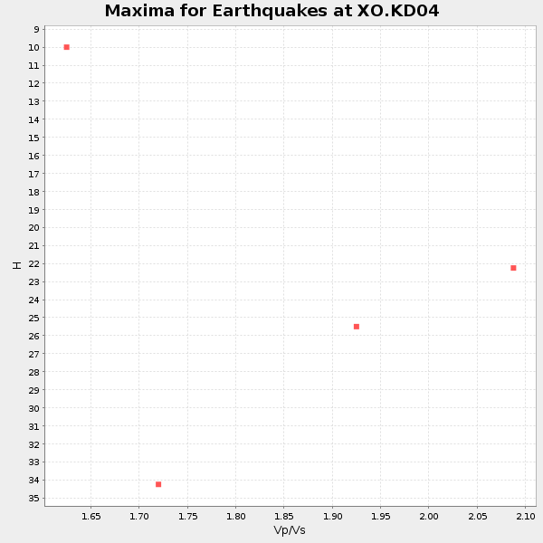
| Global Maxima | 25 km | 1.99 | 6.134 km/s | 3.086 km/s | 0.33 | amp=0.051229365 |
| Local Maxima 1 | 32 km | 1.82 | 6.134 km/s | 3.366 km/s | 0.28 | amp=0.04625093 |
| Local Maxima 2 | 25 km | 1.87 | 6.134 km/s | 3.285 km/s | 0.30 | amp=0.025504556 |
| Local Maxima 3 | 34 km | 1.70 | 6.134 km/s | 3.613 km/s | 0.23 | amp=0.018300679 |
| Local Maxima 4 | 30 km | 1.95 | 6.134 km/s | 3.15 km/s | 0.32 | amp=0.011923445 |
| Predicted Arrivals for vertical incidence (zero ray parameter) | |
| Ps | 4.02 SECOND |
| PpPs | 12.18 SECOND |
| PsPs/PpSs | 16.20 SECOND |
Events Processed for this Station
Download zip of receiver functions as SAC
Plot maxima for each earthquake.
Events Used in the Stack
(4 events)| Radial Match | Distance | Baz | FERegion | Time | Lat/Lon | Depth | Magnitude |
| 93.37071 | 59.9 deg | 253.507 deg | Mariana Islands Region | 2018/08/28 22:35:14 GMT | (16.8, 147.1) | 53 km | 6.6 Mi |
| 90.51638 | 85.1 deg | 214.199 deg | Southeast Of Loyalty Islands | 2018/08/29 03:51:55 GMT | (-22.2, 170.0) | 10 km | 7.0 Mi |
| 83.232506 | 94.9 deg | 102.614 deg | Peru-Brazil Border Region | 2018/08/24 09:04:06 GMT | (-11.0, -70.8) | 609 km | 7.1 Mww |
| 82.21838 | 48.8 deg | 272.736 deg | Near East Coast Of Honshu, Japan | 2018/07/07 11:23:49 GMT | (35.1, 140.7) | 39 km | 5.9 Mww |
Losers
(30 events)| Radial Match | Distance | Baz | FERegion | Time | Lat/Lon | Depth | Magnitude | Reason |
| 79.927055 | 56.5 deg | 261.252 deg | Volcano Islands, Japan Region | 2018/08/16 18:21:31 GMT | (23.4, 143.4) | 12 km | 5.8 Mwb | |
| 76.32774 | 71.7 deg | 102.52 deg | Costa Rica | 2018/08/17 23:22:24 GMT | (8.8, -83.2) | 15 km | 6.1 Mww | |
| 74.30632 | 32.1 deg | 276.91 deg | Kuril Islands | 2018/08/10 18:12:05 GMT | (48.5, 154.8) | 16 km | 5.9 Mww | |
| 73.61339 | 81.6 deg | 217.418 deg | Vanuatu Islands | 2018/06/21 21:13:32 GMT | (-17.8, 168.0) | 22 km | 6.1 Mww | |
| 73.48951 | 59.1 deg | 255.584 deg | Mariana Islands | 2018/07/20 23:56:00 GMT | (18.5, 146.0) | 126 km | 5.6 Mww | |
| 72.951935 | 79.9 deg | 217.929 deg | Vanuatu Islands | 2018/08/21 22:32:27 GMT | (-16.0, 168.2) | 13 km | 6.5 Mww | |
| 70.54184 | 38.2 deg | 281.779 deg | Sea Of Okhotsk | 2018/07/01 20:45:42 GMT | (46.9, 145.0) | 388 km | 5.6 Mww | |
| 66.95219 | 47.7 deg | 6.652 deg | Greenland Sea | 2018/08/07 13:57:09 GMT | (74.6, 8.4) | 10 km | 5.8 Mww | |
| 65.76326 | 38.5 deg | 275.882 deg | East Of Kuril Islands | 2018/06/02 09:48:08 GMT | (43.9, 148.0) | 10 km | 5.5 Mww | |
| 65.5274 | 82.4 deg | 216.233 deg | Vanuatu Islands | 2018/07/22 21:21:57 GMT | (-18.9, 168.9) | 100 km | 5.5 Mww | |
| 65.376305 | 82.3 deg | 216.135 deg | Vanuatu Islands | 2018/07/13 09:46:49 GMT | (-18.9, 169.0) | 169 km | 6.4 Mww | |
| 59.780983 | 80.7 deg | 266.388 deg | Mindanao, Philippines | 2018/07/03 09:59:54 GMT | (5.9, 125.2) | 100 km | 5.6 Mww | |
| 56.09676 | 63.5 deg | 106.96 deg | Near Coast Of Guatemala | 2018/08/09 19:21:53 GMT | (13.6, -91.2) | 29 km | 5.6 Mww | |
| 53.36171 | 54.7 deg | 267.538 deg | Bonin Islands, Japan Region | 2018/09/01 15:43:02 GMT | (27.9, 139.9) | 455 km | 5.6 Mww | |
| 52.804436 | 44.9 deg | 272.517 deg | Off East Coast Of Honshu, Japan | 2018/08/07 15:12:57 GMT | (37.9, 144.1) | 12 km | 5.6 Mww | |
| 50.186874 | 77.9 deg | 204.374 deg | Fiji Islands Region | 2018/08/28 13:09:10 GMT | (-18.0, -177.9) | 592 km | 5.7 Mww | |
| 49.7713 | 47.0 deg | 274.197 deg | Near East Coast Of Honshu, Japan | 2018/07/31 08:42:20 GMT | (37.2, 141.2) | 10 km | 5.4 Mww | |
| 49.354774 | 56.5 deg | 110.573 deg | Oaxaca, Mexico | 2018/07/19 13:31:53 GMT | (17.8, -97.8) | 55 km | 5.7 Mww | |
| 48.113537 | 78.8 deg | 239.711 deg | New Britain Region, P.N.G. | 2018/07/19 18:30:32 GMT | (-6.1, 148.7) | 30 km | 6.0 Mww | |
| 47.72917 | 86.9 deg | 253.584 deg | Tanimbar Islands Reg., Indonesia | 2018/08/03 05:42:14 GMT | (-6.2, 132.7) | 28 km | 5.4 Mww | |
| 44.831566 | 94.7 deg | 263.758 deg | Flores Sea | 2018/08/17 15:35:02 GMT | (-7.4, 119.8) | 539 km | 6.5 Mww | |
| 43.30331 | 77.9 deg | 204.636 deg | Fiji Islands Region | 2018/08/19 00:32:59 GMT | (-17.9, -178.2) | 520 km | 5.7 mb | |
| 41.72069 | 76.8 deg | 108.317 deg | Off Coast Of Ecuador | 2018/09/03 23:37:18 GMT | (1.5, -85.2) | 10 km | 5.9 Mww | |
| 39.24936 | 90.1 deg | 201.513 deg | Kermadec Islands, New Zealand | 2018/07/07 21:33:49 GMT | (-30.6, -178.0) | 34 km | 5.9 Mww | |
| 34.16907 | 87.1 deg | 344.386 deg | Western Iran | 2018/07/22 10:07:27 GMT | (34.6, 46.2) | 12 km | 5.8 Mww | |
| 27.463356 | 76.7 deg | 226.198 deg | Solomon Islands | 2018/06/22 19:24:30 GMT | (-10.0, 161.7) | 43 km | 5.4 Mww | |
| 25.686922 | 77.2 deg | 226.593 deg | Solomon Islands | 2018/06/23 00:33:39 GMT | (-10.3, 161.1) | 23 km | 5.5 Mww | |
| 24.107363 | 56.4 deg | 261.345 deg | Volcano Islands, Japan Region | 2018/08/17 22:06:57 GMT | (23.5, 143.3) | 18 km | 5.5 Mww | |
| 21.390638 | 82.3 deg | 215.663 deg | Vanuatu Islands | 2018/07/08 21:04:36 GMT | (-19.0, 169.5) | 259 km | 5.5 Mww | |
| 20.813774 | 74.8 deg | 97.398 deg | Panama-Colombia Border Region | 2018/08/18 19:39:07 GMT | (8.8, -77.3) | 10 km | 5.6 Mww |

