
Station XO VASR - Vassar College Farm, Poughkeepsie, NY
Network: XO97 - NOMAD
Nearby stations (2 deg radius)
| Station | Name | (Lat, Lon) | Start / End | Elevation |
| VASR | Vassar College Farm, Poughkeepsie, NY | (41.67, -73.90) | 1997-06-03 / 1998-10-06 | 38 m |
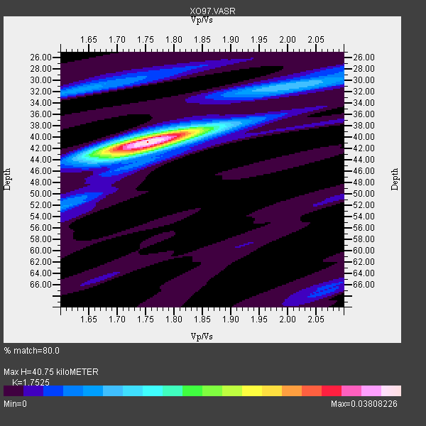
| Crust2 Type: | T6,Margin /shield transition, 1 km seds. |
| Thickness Estimate: | 41 km |
| Thickness StdDev: | 1.1 km |
| Vp/Vs Estimate: | 1.75 |
| Vp/Vs StdDev: | 0.03 |
| Vs Estimate: | 3.693 km/s |
| Poisson's Ratio: | 0.26 |
| Peak Value: | 0.04 |
| Assumed Vp: | 6.472 km/s |
| Ps Weight: | 0.33333334 |
| PpPs Weight: | 0.33333334 |
| PsPs Weight: | 0.33333328 |
| Residual Complexity: | 0.405 |
| Nearby stations H: | +- |
| (2.0 deg) Vp/Vs: | +- |
15 with match > 90% ( 37.5 %) and 21 with match > 80% ( 52.5 %) out of 40.
Download stack as xyz text file.
Azimuth Distribution of Events:

Prior Results for this Station
| Study | Thickness | Vp/Vs | Vp | Vs | Poissons Ratio | Extra |
| EARS | 41 km | 1.75 | 6.472 km/s | 3.693 km/s | 0.26 | |
| Crust2.0 | 32 km | 1.79 | 6.472 km/s | 3.622 km/s | 0.27 | T6,Margin /shield transition, 1 km seds. |
| Global Maxima | 41 km | 1.75 | 6.472 km/s | 3.693 km/s | 0.26 | amp=0.03808226 |
| Local Maxima 1 | 42 km | 1.73 | 6.472 km/s | 3.746 km/s | 0.25 | amp=0.015666168 |
| Local Maxima 2 | 31 km | 2.01 | 6.472 km/s | 3.22 km/s | 0.34 | amp=0.009459449 |
| Local Maxima 3 | 32 km | 1.62 | 6.472 km/s | 4.001 km/s | 0.19 | amp=0.008419963 |
| Local Maxima 4 | 39 km | 1.81 | 6.472 km/s | 3.576 km/s | 0.28 | amp=0.007186638 |
| Predicted Arrivals for vertical incidence (zero ray parameter) | |
| Ps | 4.74 SECOND |
| PpPs | 17.33 SECOND |
| PsPs/PpSs | 22.07 SECOND |
Events Processed for this Station
Download zip of receiver functions as SAC
Plot maxima for each earthquake.
Events Used in the Stack
(21 events)| Radial Match | Distance | Baz | FERegion | Time | Lat/Lon | Depth | Magnitude |
| 98.49401 | 73.7 deg | 177.697 deg | Near Coast Of Central Chile | 1998/07/29 07:14:24 GMT | (-32.3, -71.3) | 51 km | 6.3 MB, 6.5 UNKNOWN, 6.5 ME |
| 98.21717 | 72.3 deg | 177.587 deg | Near Coast Of Central Chile | 1997/10/15 01:03:33 GMT | (-30.9, -71.2) | 58 km | 6.8 MB, 6.8 MS, 7.3 UNKNOWN, 7.1 MW |
| 97.172226 | 72.7 deg | 329.876 deg | Near East Coast Of Kamchatka | 1997/12/05 11:26:54 GMT | (54.8, 162.0) | 33 km | 6.3 MB, 7.6 MS, 7.9 UNKNOWN, 7.3 ME |
| 97.156624 | 42.5 deg | 189.646 deg | Near Coast Of Ecuador | 1998/08/04 18:59:20 GMT | (-0.6, -80.4) | 33 km | 6.2 MB, 7.1 MS, 7.1 UNKNOWN, 7.0 ME |
| 96.787964 | 71.4 deg | 178.149 deg | Near Coast Of Central Chile | 1997/07/06 09:54:00 GMT | (-30.1, -71.9) | 19 km | 5.8 MB, 6.5 MS, 6.8 UNKNOWN, 6.4 ME |
| 94.84025 | 45.9 deg | 183.87 deg | Northern Peru | 1997/10/28 06:15:17 GMT | (-4.4, -76.7) | 112 km | 6.6 MB, 6.3 MS, 7.2 UNKNOWN, 6.6 ME |
| 94.520294 | 72.3 deg | 177.76 deg | Near Coast Of Central Chile | 1998/01/12 10:14:07 GMT | (-31.0, -71.4) | 35 km | 5.8 MB, 6.2 MS, 6.6 UNKNOWN, 6.2 ME |
| 93.76929 | 32.4 deg | 206.567 deg | Off Coast Of Central America | 1998/08/23 13:57:15 GMT | (11.7, -88.0) | 55 km | 5.7 MB, 6.3 MS, 6.8 UNKNOWN, 6.7 MW |
| 93.70293 | 31.2 deg | 214.423 deg | Guatemala | 1998/01/10 08:20:05 GMT | (14.4, -91.5) | 33 km | 6.1 MB, 6.2 MS, 6.6 UNKNOWN, 6.6 ME |
| 93.34295 | 65.3 deg | 176.286 deg | Near Coast Of Northern Chile | 1998/01/30 12:16:08 GMT | (-23.9, -70.2) | 42 km | 6.3 MB, 6.5 MS, 7.0 UNKNOWN, 6.7 ME |
| 92.86421 | 34.4 deg | 79.705 deg | Azores Islands, Portugal | 1998/07/09 05:19:07 GMT | (38.7, -28.6) | 10 km | 5.7 MB, 6.0 MS, 6.6 UNKNOWN, 6.2 MW |
| 90.98774 | 71.9 deg | 178.153 deg | Near Coast Of Central Chile | 1997/07/27 05:21:29 GMT | (-30.5, -71.9) | 33 km | 5.6 MB, 5.8 MS, 6.3 UNKNOWN, 6.2 MW |
| 90.770256 | 37.7 deg | 183.026 deg | Colombia | 1997/09/02 12:13:22 GMT | (3.8, -75.7) | 199 km | 6.5 MB, 6.8 UNKNOWN, 6.4 ME |
| 90.72641 | 36.0 deg | 79.308 deg | Azores Islands, Portugal | 1997/06/27 04:39:52 GMT | (38.3, -26.7) | 10 km | 5.6 MB, 5.4 MS, 5.9 UNKNOWN, 5.9 MW |
| 90.68981 | 67.0 deg | 318.946 deg | Andreanof Islands, Aleutian Is. | 1997/06/17 21:03:40 GMT | (51.3, -179.3) | 33 km | 6.4 MB, 6.3 MS, 6.4 UNKNOWN, 6.6 ML |
| 86.85708 | 70.8 deg | 177.986 deg | Near Coast Of Central Chile | 1998/09/03 17:37:58 GMT | (-29.5, -71.7) | 27 km | 6.2 MB, 6.6 MS, 6.5 UNKNOWN, 6.4 ME |
| 86.09276 | 31.2 deg | 214.416 deg | Guatemala | 1998/03/03 02:24:43 GMT | (14.4, -91.5) | 63 km | 5.5 MB, 5.4 MS, 6.2 UNKNOWN, 6.1 MW |
| 85.841385 | 30.8 deg | 219.671 deg | Near Coast Of Chiapas, Mexico | 1998/06/07 23:20:13 GMT | (16.0, -93.8) | 87 km | 5.8 MB, 6.3 UNKNOWN, 6.3 MW |
| 84.87756 | 81.6 deg | 180.756 deg | Off Coast Of Southern Chile | 1998/04/01 22:42:56 GMT | (-40.3, -74.9) | 9.0 km | 6.2 MB, 6.0 MS, 6.7 UNKNOWN, 6.6 ME |
| 81.43551 | 70.8 deg | 58.182 deg | Southern Greece | 1997/10/13 13:39:37 GMT | (36.4, 22.1) | 24 km | 6.2 MB, 6.6 MS, 6.7 UNKNOWN, 6.5 MW |
| 81.161064 | 64.7 deg | 172.258 deg | Jujuy Province, Argentina | 1997/07/20 10:14:22 GMT | (-23.0, -66.3) | 256 km | 5.7 MB, 6.1 UNKNOWN, 5.7 ME |
Losers
(19 events)| Radial Match | Distance | Baz | FERegion | Time | Lat/Lon | Depth | Magnitude | Reason |
| 79.657135 | 55.3 deg | 173.962 deg | Peru-Bolivia Border Region | 1997/11/28 22:53:41 GMT | (-13.7, -68.8) | 586 km | 6.4 MB, 6.6 UNKNOWN, 6.6 MW | |
| 79.25035 | 32.1 deg | 223.574 deg | Near Coast Of Oaxaca, Mexico | 1998/02/03 03:02:00 GMT | (15.9, -96.3) | 33 km | 6.0 MB, 6.2 MS, 6.3 UNKNOWN, 6.4 MD | |
| 77.11172 | 37.6 deg | 183.093 deg | Colombia | 1997/12/11 07:56:28 GMT | (3.9, -75.8) | 178 km | 6.0 MB, 6.4 UNKNOWN, 6.3 MW | |
| 74.430786 | 74.9 deg | 329.509 deg | Off East Coast Of Kamchatka | 1998/06/01 05:34:03 GMT | (52.9, 160.1) | 44 km | 6.2 MB, 6.3 MS, 6.5 UNKNOWN, 6.4 MW | |
| 72.90091 | 31.3 deg | 211.948 deg | Near Coast Of Guatemala | 1997/12/22 10:03:45 GMT | (13.7, -90.3) | 59 km | 5.1 MB, 6.1 UNKNOWN, 5.2 MD | |
| 69.530655 | 88.0 deg | 332.934 deg | Hokkaido, Japan Region | 1997/11/15 07:05:16 GMT | (43.8, 145.0) | 161 km | 5.8 MB, 6.1 UNKNOWN, 6.1 MW | |
| 68.47448 | 69.2 deg | 57.911 deg | Ionian Sea | 1997/11/18 13:07:41 GMT | (37.6, 20.7) | 33 km | 5.9 MB, 6.4 MS, 6.7 UNKNOWN, 6.1 ML | |
| 68.37248 | 68.0 deg | 319.579 deg | Rat Islands, Aleutian Islands | 1997/12/17 04:38:51 GMT | (51.2, 178.9) | 20 km | 5.8 MB, 6.5 MS, 6.7 UNKNOWN, 6.1 ME | |
| 67.15978 | 63.7 deg | 316.665 deg | Andreanof Islands, Aleutian Is. | 1998/09/14 23:16:46 GMT | (51.6, -173.1) | 33 km | 5.7 MB, 6.0 MS, 6.2 UNKNOWN, 5.7 ML | |
| 63.39702 | 61.0 deg | 315.679 deg | Fox Islands, Aleutian Islands | 1998/01/23 09:20:08 GMT | (52.4, -168.6) | 33 km | 5.8 MB, 5.5 MS, 5.8 UNKNOWN, 5.5 ML | |
| 62.918575 | 72.8 deg | 329.521 deg | Near East Coast Of Kamchatka | 1997/12/05 11:37:09 GMT | (54.5, 162.3) | 33 km | 5.6 MB | |
| 62.347946 | 71.8 deg | 178.192 deg | Near Coast Of Central Chile | 1997/07/25 06:47:02 GMT | (-30.5, -71.9) | 33 km | 5.6 MB, 5.5 MS, 6.3 UNKNOWN | |
| 60.55174 | 72.1 deg | 177.684 deg | Near Coast Of Central Chile | 1997/11/03 20:12:52 GMT | (-30.8, -71.3) | 45 km | 5.6 MB, 5.2 MD | |
| 57.98919 | 77.1 deg | 333.482 deg | Sea Of Okhotsk | 1997/12/20 13:26:31 GMT | (53.4, 152.8) | 614 km | 5.9 UNKNOWN, 5.1 MB, 5.9 MW | |
| 56.49144 | 83.2 deg | 207.419 deg | Southern East Pacific Rise | 1997/06/10 21:53:55 GMT | (-35.8, -108.1) | 10 km | 5.8 MB, 6.1 MS, 6.5 UNKNOWN, 5.8 MS | |
| 43.97129 | 73.0 deg | 174.589 deg | San Juan Province, Argentina | 1998/06/07 16:10:46 GMT | (-31.5, -67.8) | 113 km | 5.6 MB, 5.9 UNKNOWN, 5.9 MW | |
| 43.251637 | 66.2 deg | 318.408 deg | Andreanof Islands, Aleutian Is. | 1997/10/15 03:11:09 GMT | (51.4, -177.9) | 22 km | 5.7 MB, 6.1 MS, 6.3 UNKNOWN, 5.6 ML | |
| 37.406914 | 60.3 deg | 315.44 deg | Fox Islands, Aleutian Islands | 1997/07/20 00:30:20 GMT | (52.6, -167.5) | 14 km | 5.6 MB, 5.9 MS, 6.2 UNKNOWN, 6.2 MW | |
| 32.586613 | 64.7 deg | 59.176 deg | Southern Italy | 1998/05/18 17:19:04 GMT | (39.3, 15.1) | 280 km | 5.6 MB |
