
Station XO WIND - Windham, NY
Network: XO97 - NOMAD
Nearby stations (2 deg radius)
| Station | Name | (Lat, Lon) | Start / End | Elevation |
| WIND | Windham, NY | (42.33, -74.27) | 1997-06-21 / 1998-10-05 | 580 m |
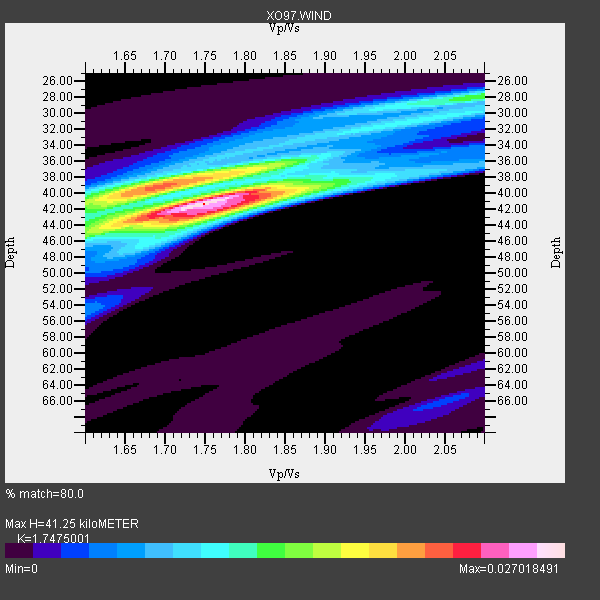
| Crust2 Type: | Q2,orogen/39km no ice, Appalachians, North Andes, 0.5 km seds. |
| Thickness Estimate: | 41 km |
| Thickness StdDev: | 2.0 km |
| Vp/Vs Estimate: | 1.75 |
| Vp/Vs StdDev: | 0.05 |
| Vs Estimate: | 3.673 km/s |
| Poisson's Ratio: | 0.26 |
| Peak Value: | 0.03 |
| Assumed Vp: | 6.419 km/s |
| Ps Weight: | 0.33333334 |
| PpPs Weight: | 0.33333334 |
| PsPs Weight: | 0.33333328 |
| Residual Complexity: | 0.670 |
| Nearby stations H: | +- |
| (2.0 deg) Vp/Vs: | +- |
12 with match > 90% ( 25.531916 %) and 18 with match > 80% ( 38.29787 %) out of 47.
Download stack as xyz text file.
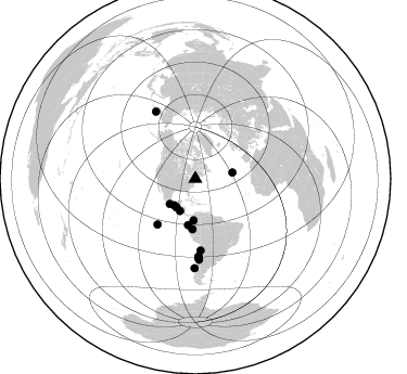
Azimuth Distribution of Events:
Prior Results for this Station
| Study | Thickness | Vp/Vs | Vp | Vs | Poissons Ratio | Extra |
| EARS | 41 km | 1.75 | 6.419 km/s | 3.673 km/s | 0.26 | |
| Crust2.0 | 39 km | 1.75 | 6.419 km/s | 3.659 km/s | 0.26 | Q2,orogen/39km no ice, Appalachians, North Andes, 0.5 km seds. |
| Global Maxima | 41 km | 1.75 | 6.419 km/s | 3.673 km/s | 0.26 | amp=0.027018491 |
| Local Maxima 1 | 39 km | 1.68 | 6.419 km/s | 3.832 km/s | 0.22 | amp=0.019947007 |
| Local Maxima 2 | 42 km | 1.75 | 6.419 km/s | 3.668 km/s | 0.26 | amp=0.0137967 |
| Local Maxima 3 | 28 km | 2.10 | 6.419 km/s | 3.06 km/s | 0.35 | amp=0.0122329015 |
| Local Maxima 4 | 42 km | 1.62 | 6.419 km/s | 3.95 km/s | 0.20 | amp=0.008485933 |
| Predicted Arrivals for vertical incidence (zero ray parameter) | |
| Ps | 4.80 SECOND |
| PpPs | 17.66 SECOND |
| PsPs/PpSs | 22.46 SECOND |
Events Processed for this Station
Download zip of receiver functions as SAC
Plot maxima for each earthquake.
Events Used in the Stack
(18 events)| Radial Match | Distance | Baz | FERegion | Time | Lat/Lon | Depth | Magnitude |
| 98.39391 | 74.3 deg | 177.375 deg | Near Coast Of Central Chile | 1998/07/29 07:14:24 GMT | (-32.3, -71.3) | 51 km | 6.3 MB, 6.5 UNKNOWN, 6.5 ME |
| 97.48621 | 43.1 deg | 188.983 deg | Near Coast Of Ecuador | 1998/08/04 18:59:20 GMT | (-0.6, -80.4) | 33 km | 6.2 MB, 7.1 MS, 7.1 UNKNOWN, 7.0 ME |
| 96.60994 | 72.1 deg | 177.814 deg | Near Coast Of Central Chile | 1997/07/06 09:54:00 GMT | (-30.1, -71.9) | 19 km | 5.8 MB, 6.5 MS, 6.8 UNKNOWN, 6.4 ME |
| 94.88899 | 46.5 deg | 183.313 deg | Northern Peru | 1997/10/28 06:15:17 GMT | (-4.4, -76.7) | 112 km | 6.6 MB, 6.3 MS, 7.2 UNKNOWN, 6.6 ME |
| 94.73011 | 72.0 deg | 329.597 deg | Near East Coast Of Kamchatka | 1997/12/05 11:26:54 GMT | (54.8, 162.0) | 33 km | 6.3 MB, 7.6 MS, 7.9 UNKNOWN, 7.3 ME |
| 94.50046 | 33.0 deg | 225.612 deg | Near Coast Of Guerrero, Mexico | 1997/07/19 14:22:08 GMT | (16.3, -98.2) | 33 km | 5.7 MB, 6.3 MS, 6.8 UNKNOWN, 6.0 ME |
| 94.35557 | 73.0 deg | 177.431 deg | Near Coast Of Central Chile | 1998/01/12 10:14:07 GMT | (-31.0, -71.4) | 35 km | 5.8 MB, 6.2 MS, 6.6 UNKNOWN, 6.2 ME |
| 94.22692 | 32.8 deg | 205.472 deg | Off Coast Of Central America | 1998/08/23 13:57:15 GMT | (11.7, -88.0) | 55 km | 5.7 MB, 6.3 MS, 6.8 UNKNOWN, 6.7 MW |
| 93.41549 | 38.3 deg | 182.378 deg | Colombia | 1997/09/02 12:13:22 GMT | (3.8, -75.7) | 199 km | 6.5 MB, 6.8 UNKNOWN, 6.4 ME |
| 93.18799 | 34.6 deg | 80.469 deg | Azores Islands, Portugal | 1998/07/09 05:19:07 GMT | (38.7, -28.6) | 10 km | 5.7 MB, 6.0 MS, 6.6 UNKNOWN, 6.2 MW |
| 92.555336 | 66.0 deg | 175.93 deg | Near Coast Of Northern Chile | 1998/01/30 12:16:08 GMT | (-23.9, -70.2) | 42 km | 6.3 MB, 6.5 MS, 7.0 UNKNOWN, 6.7 ME |
| 90.77718 | 82.3 deg | 180.466 deg | Off Coast Of Southern Chile | 1998/04/01 22:42:56 GMT | (-40.3, -74.9) | 9.0 km | 6.2 MB, 6.0 MS, 6.7 UNKNOWN, 6.6 ME |
| 89.86212 | 72.5 deg | 177.821 deg | Near Coast Of Central Chile | 1997/07/27 05:21:29 GMT | (-30.5, -71.9) | 33 km | 5.6 MB, 5.8 MS, 6.3 UNKNOWN, 6.2 MW |
| 89.57493 | 31.6 deg | 213.191 deg | Guatemala | 1998/01/10 08:20:05 GMT | (14.4, -91.5) | 33 km | 6.1 MB, 6.2 MS, 6.6 UNKNOWN, 6.6 ME |
| 88.06999 | 31.6 deg | 213.184 deg | Guatemala | 1998/03/03 02:24:43 GMT | (14.4, -91.5) | 63 km | 5.5 MB, 5.4 MS, 6.2 UNKNOWN, 6.1 MW |
| 85.68291 | 31.2 deg | 218.369 deg | Near Coast Of Chiapas, Mexico | 1998/06/07 23:20:13 GMT | (16.0, -93.8) | 87 km | 5.8 MB, 6.3 UNKNOWN, 6.3 MW |
| 85.10514 | 71.5 deg | 177.649 deg | Near Coast Of Central Chile | 1998/09/03 17:37:58 GMT | (-29.5, -71.7) | 27 km | 6.2 MB, 6.6 MS, 6.5 UNKNOWN, 6.4 ME |
| 83.0019 | 54.5 deg | 219.666 deg | Central East Pacific Rise | 1997/08/15 07:37:49 GMT | (-4.4, -105.7) | 10 km | 5.3 MB, 5.8 MS, 6.2 UNKNOWN, 6.1 MW |
Losers
(29 events)| Radial Match | Distance | Baz | FERegion | Time | Lat/Lon | Depth | Magnitude | Reason |
| 77.529594 | 38.3 deg | 182.444 deg | Colombia | 1997/12/11 07:56:28 GMT | (3.9, -75.8) | 178 km | 6.0 MB, 6.4 UNKNOWN, 6.3 MW | |
| 76.98564 | 33.6 deg | 226.31 deg | Near Coast Of Guerrero, Mexico | 1997/12/16 11:48:29 GMT | (16.1, -98.9) | 10 km | 5.5 MB, 5.5 MS, 6.3 UNKNOWN, 6.2 MW | |
| 76.75857 | 32.4 deg | 222.289 deg | Near Coast Of Oaxaca, Mexico | 1998/02/03 03:02:00 GMT | (15.9, -96.3) | 33 km | 6.0 MB, 6.2 MS, 6.3 UNKNOWN, 6.4 MD | |
| 76.593056 | 31.7 deg | 210.748 deg | Near Coast Of Guatemala | 1997/12/22 10:03:45 GMT | (13.7, -90.3) | 59 km | 5.1 MB, 6.1 UNKNOWN, 5.2 MD | |
| 76.06065 | 56.0 deg | 173.571 deg | Peru-Bolivia Border Region | 1997/11/28 22:53:41 GMT | (-13.7, -68.8) | 586 km | 6.4 MB, 6.6 UNKNOWN, 6.6 MW | |
| 74.22413 | 68.7 deg | 321.19 deg | Rat Islands, Aleutian Islands | 1998/08/20 15:00:08 GMT | (51.6, 175.2) | 33 km | 5.6 MB, 6.0 MS, 6.2 UNKNOWN, 6.2 MW | |
| 73.437256 | 74.2 deg | 329.233 deg | Off East Coast Of Kamchatka | 1998/06/01 05:34:03 GMT | (52.9, 160.1) | 44 km | 6.2 MB, 6.3 MS, 6.5 UNKNOWN, 6.4 MW | |
| 72.90662 | 63.1 deg | 316.289 deg | Andreanof Islands, Aleutian Is. | 1998/09/14 23:16:46 GMT | (51.6, -173.1) | 33 km | 5.7 MB, 6.0 MS, 6.2 UNKNOWN, 5.7 ML | |
| 72.7961 | 95.4 deg | 27.671 deg | Hindu Kush Region, Afghanistan | 1997/12/17 05:51:29 GMT | (36.4, 70.8) | 207 km | 5.5 MB, 6.3 UNKNOWN | |
| 69.69081 | 65.4 deg | 171.921 deg | Jujuy Province, Argentina | 1997/07/20 10:14:22 GMT | (-23.0, -66.3) | 256 km | 5.7 MB, 6.1 UNKNOWN, 5.7 ME | |
| 69.49566 | 31.0 deg | 208.089 deg | El Salvador | 1997/12/18 15:02:00 GMT | (13.8, -88.7) | 182 km | 5.3 MB, 6.1 UNKNOWN, 6.0 MW | |
| 64.8958 | 84.0 deg | 41.4 deg | Armenia-Azerbaijan-Iran Bord Reg | 1998/07/09 14:19:18 GMT | (38.7, 48.5) | 26 km | 5.9 MB, 6.0 UNKNOWN, 5.7 ME | |
| 64.48851 | 60.3 deg | 170.294 deg | Central Bolivia | 1998/05/22 04:48:50 GMT | (-17.7, -65.4) | 24 km | 5.9 MB, 6.6 MS, 6.6 UNKNOWN, 6.2 ME | |
| 60.62691 | 70.6 deg | 59.377 deg | Central Mediterranean Sea | 1997/07/27 10:07:52 GMT | (35.6, 21.1) | 33 km | 5.5 MB, 4.8 MS, 5.6 UNKNOWN, 5.2 ML | |
| 55.574043 | 65.9 deg | 318.302 deg | Andreanof Islands, Aleutian Is. | 1997/07/08 12:11:15 GMT | (51.4, -178.6) | 33 km | 5.5 MB, 5.4 MS, 5.8 UNKNOWN, 5.6 ML | |
| 54.695957 | 65.9 deg | 114.25 deg | North Of Ascension Island | 1998/03/29 07:14:58 GMT | (-0.2, -17.9) | 10 km | 5.5 MB, 5.6 MS, 6.1 UNKNOWN, 6.1 MW | |
| 53.905975 | 95.4 deg | 40.373 deg | Northern And Central Iran | 1998/03/14 19:40:27 GMT | (30.2, 57.6) | 9.0 km | 5.9 MB, 6.9 MS, 6.6 UNKNOWN, 6.3 ME | |
| 51.906193 | 94.5 deg | 27.872 deg | Afghanistan-Tajikistan Bord Reg. | 1998/02/04 14:33:21 GMT | (37.1, 70.1) | 33 km | 5.6 MB, 6.1 MS, 6.0 UNKNOWN, 5.9 MW | |
| 51.822353 | 37.8 deg | 130.371 deg | Northern Mid-Atlantic Ridge | 1998/10/01 03:41:13 GMT | (13.7, -45.6) | 10 km | 5.4 MB, 5.5 MS, 6.1 UNKNOWN, 5.9 MW | |
| 49.77325 | 73.7 deg | 174.275 deg | San Juan Province, Argentina | 1998/06/07 16:10:46 GMT | (-31.5, -67.8) | 113 km | 5.6 MB, 5.9 UNKNOWN, 5.9 MW | |
| 48.488705 | 87.3 deg | 331.541 deg | Kuril Islands | 1997/07/14 16:09:35 GMT | (43.2, 146.4) | 33 km | 5.9 MB, 5.8 MS, 6.1 UNKNOWN, 5.8 ME | |
| 47.65109 | 71.3 deg | 177.614 deg | Near Coast Of Central Chile | 1997/07/19 12:22:57 GMT | (-29.3, -71.7) | 26 km | 5.8 MB, 5.5 MS, 5.9 UNKNOWN, 5.8 MW | |
| 45.509514 | 64.6 deg | 174.037 deg | Northern Chile | 1997/09/28 23:13:13 GMT | (-22.4, -68.4) | 107 km | 5.7 MB, 5.6 UNKNOWN, 5.6 MW | |
| 42.82561 | 32.9 deg | 232.202 deg | Guerrero, Mexico | 1998/04/20 22:59:14 GMT | (18.5, -101.2) | 67 km | 5.9 MB, 6.0 UNKNOWN, 5.9 MW | |
| 42.23449 | 73.0 deg | 329.065 deg | Off East Coast Of Kamchatka | 1997/12/06 00:25:06 GMT | (53.7, 161.6) | 33 km | 5.5 MS, 5.3 MB, 5.7 UNKNOWN | |
| 37.730602 | 93.9 deg | 136.022 deg | Southern Mid-Atlantic Ridge | 1998/01/03 06:10:08 GMT | (-35.5, -16.2) | 10 km | 5.9 MS, 5.4 MB, 6.3 UNKNOWN, 6.1 MW | |
| 33.194534 | 65.5 deg | 318.055 deg | Andreanof Islands, Aleutian Is. | 1997/10/15 03:11:09 GMT | (51.4, -177.9) | 22 km | 5.7 MB, 6.1 MS, 6.3 UNKNOWN, 5.6 ML | |
| 31.165329 | 74.9 deg | 329.08 deg | Off East Coast Of Kamchatka | 1998/05/27 20:41:37 GMT | (52.2, 159.5) | 60 km | 5.5 MB, 6.0 UNKNOWN, 5.9 MW | |
| 23.86129 | 71.8 deg | 329.08 deg | Near East Coast Of Kamchatka | 1997/12/07 17:56:18 GMT | (54.7, 162.9) | 33 km | 5.6 MB, 6.0 MS, 6.3 UNKNOWN, 6.1 MW |
