
Station XQ NC04 - NC04
Network: XQ12 - Pre-Hydrofracking Regional Assessment of Central Carolina Seismicity
Nearby stations (2 deg radius)
| Station | Name | (Lat, Lon) | Start / End | Elevation |
| NC04 | NC04 | (35.55, -79.24) | 2012-03-25 / 2014-12-31 | 92 m |
| Crust2 Type: | DG,thin Platform 1 km seds. |
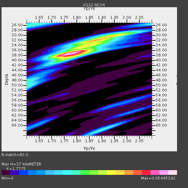
| Thickness Estimate: | 37 km |
| Thickness StdDev: | 2.5 km |
| Vp/Vs Estimate: | 1.78 |
| Vp/Vs StdDev: | 0.05 |
| Vs Estimate: | 3.693 km/s |
| Poisson's Ratio: | 0.27 |
| Peak Value: | 0.05 |
| Assumed Vp: | 6.565 km/s |
| Ps Weight: | 0.33333334 |
| PpPs Weight: | 0.33333334 |
| PsPs Weight: | 0.33333328 |
| Residual Complexity: | 0.631 |
| Nearby stations H: | +- |
| (2.0 deg) Vp/Vs: | +- |
5 with match > 90% ( 11.904762 %) and 7 with match > 80% ( 16.666666 %) out of 42.
Download stack as xyz text file.
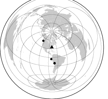
Azimuth Distribution of Events:
Prior Results for this Station
| Study | Thickness | Vp/Vs | Vp | Vs | Poissons Ratio | Extra |
| EARS | 37 km | 1.78 | 6.565 km/s | 3.693 km/s | 0.27 | |
| Crust2.0 | 31 km | 1.78 | 6.565 km/s | 3.684 km/s | 0.27 | DG,thin Platform 1 km seds. |
| Global Maxima | 37 km | 1.78 | 6.565 km/s | 3.693 km/s | 0.27 | amp=0.05445392 |
| Local Maxima 1 | 31 km | 1.90 | 6.565 km/s | 3.46 km/s | 0.31 | amp=0.031611864 |
| Local Maxima 2 | 50 km | 1.60 | 6.565 km/s | 4.103 km/s | 0.18 | amp=0.02447982 |
| Local Maxima 3 | 26 km | 1.61 | 6.565 km/s | 4.084 km/s | 0.18 | amp=0.02431714 |
| Local Maxima 4 | 67 km | 1.91 | 6.565 km/s | 3.441 km/s | 0.31 | amp=0.021273067 |
| Predicted Arrivals for vertical incidence (zero ray parameter) | |
| Ps | 4.38 SECOND |
| PpPs | 15.65 SECOND |
| PsPs/PpSs | 20.04 SECOND |
Events Processed for this Station
Download zip of receiver functions as SAC
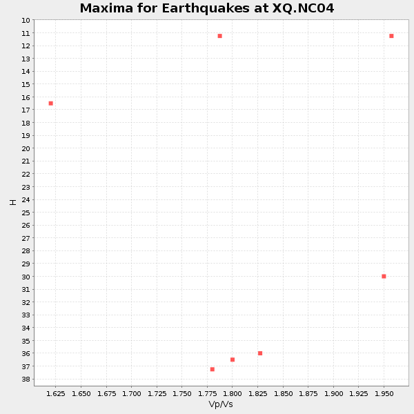
Plot maxima for each earthquake.
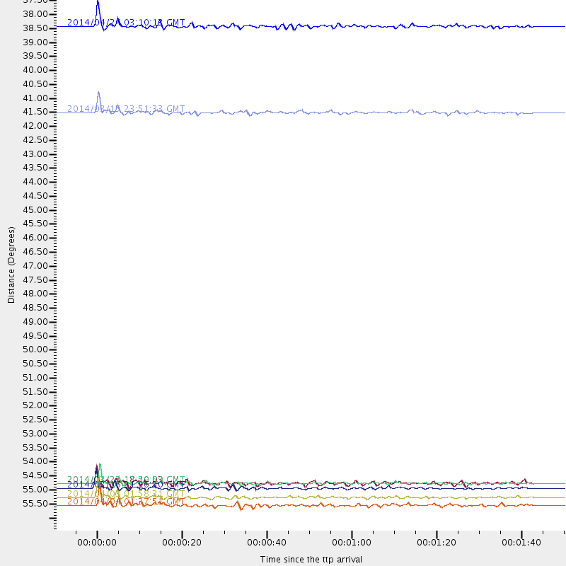
Events Used in the Stack
(7 events)| Radial Match | Distance | Baz | FERegion | Time | Lat/Lon | Depth | Magnitude |
| 95.98822 | 55.8 deg | 170.186 deg | Near Coast Of Northern Chile | 2014/03/16 21:16:30 GMT | (-19.9, -70.6) | 20 km | 6.7 MWW, 6.7 MWC, 7.0 MI |
| 95.37162 | 55.6 deg | 170.435 deg | Near Coast Of Northern Chile | 2014/03/22 12:59:59 GMT | (-19.8, -70.9) | 20 km | 6.2 MWW, 6.2 MWB, 6.3 MWC, 6.4 MWC |
| 93.45087 | 56.1 deg | 170.167 deg | Near Coast Of Northern Chile | 2014/04/03 01:58:31 GMT | (-20.3, -70.6) | 23 km | 6.5 MWW, 6.5 MWB, 6.6 MWC |
| 92.648125 | 37.5 deg | 307.607 deg | Vancouver Island, Canada Region | 2014/04/24 03:10:13 GMT | (49.8, -127.4) | 11 km | 6.7 MWP, 6.7 MI |
| 92.2758 | 56.4 deg | 170.433 deg | Near Coast Of Northern Chile | 2014/04/04 01:37:51 GMT | (-20.6, -70.7) | 20 km | 6.1 MWP, 6.1 MWB, 6.1 MWW, 6.3 MWC |
| 86.67191 | 55.6 deg | 170.361 deg | Near Coast Of Northern Chile | 2014/03/23 18:20:03 GMT | (-19.7, -70.8) | 35 km | 6.0 MB, 6.2 MWB, 6.2 MWW, 6.3 MWC |
| 85.91652 | 40.9 deg | 182.604 deg | Near Coast Of Northern Peru | 2014/03/15 23:51:33 GMT | (-5.6, -81.0) | 29 km | 6.3 MWW, 6.2 MWB, 6.3 MWC |
Losers
(35 events)| Radial Match | Distance | Baz | FERegion | Time | Lat/Lon | Depth | Magnitude | Reason |
| 98.801 | 55.5 deg | 170.35 deg | Near Coast Of Northern Chile | 2014/04/01 23:46:46 GMT | (-19.6, -70.8) | 20 km | 8.2 MWW, 8.0 MI, 8.1 MWC | |
| 98.41783 | 56.4 deg | 170.146 deg | Near Coast Of Northern Chile | 2014/04/03 02:43:14 GMT | (-20.5, -70.5) | 31 km | 7.7 MWW, 7.4 MI, 7.7 MWC | |
| 92.59048 | 36.1 deg | 292.467 deg | Off Coast Of Northern California | 2014/03/10 05:18:13 GMT | (40.8, -125.1) | 17 km | 6.8 MW, 6.8 MWR, 6.9 MWW, 6.9 MWB, 7.0 MI, 7.0 MWC | |
| 74.02217 | 49.5 deg | 176.253 deg | Near Coast Of Peru | 2014/03/15 08:59:21 GMT | (-14.1, -76.3) | 20 km | 6.1 MWW, 6.0 MWB, 6.2 MWC | |
| 71.45497 | 49.6 deg | 175.358 deg | Near Coast Of Peru | 2014/02/18 23:35:58 GMT | (-14.2, -75.6) | 57 km | 6.0 MWB, 5.9 MWW, 5.9 MWC, 6.0 MWC | |
| 68.18011 | 56.4 deg | 170.387 deg | Near Coast Of Northern Chile | 2014/04/03 09:23:21 GMT | (-20.6, -70.7) | 15 km | 5.6 MB, 5.3 MWR | |
| 63.520992 | 71.1 deg | 105.65 deg | North Of Ascension Island | 2014/04/30 15:52:42 GMT | (-1.2, -13.5) | 14 km | 5.8 MW | |
| 63.035107 | 76.5 deg | 326.717 deg | Off East Coast Of Kamchatka | 2014/04/20 13:50:41 GMT | (53.1, 163.1) | 36 km | 5.2 MW | |
| 62.930164 | 58.4 deg | 168.474 deg | Northern Chile | 2014/02/10 11:00:09 GMT | (-22.3, -68.7) | 107 km | 5.2 MW | |
| 61.600723 | 55.9 deg | 170.463 deg | Near Coast Of Northern Chile | 2014/04/02 06:29:16 GMT | (-20.1, -70.8) | 15 km | 5.2 mb | |
| 61.239296 | 55.0 deg | 332.384 deg | Northern Alaska | 2014/05/03 08:57:12 GMT | (67.6, -162.2) | 0.9 km | 5.5 MB | |
| 60.864872 | 56.6 deg | 170.376 deg | Near Coast Of Northern Chile | 2014/04/14 05:56:20 GMT | (-20.7, -70.7) | 30 km | 5.3 MW | |
| 60.05159 | 63.7 deg | 318.391 deg | Fox Islands, Aleutian Islands | 2014/02/26 21:13:40 GMT | (53.6, -171.8) | 265 km | 6.1 MWW, 5.9 MI, 5.9 ML, 6.1 MWC, 6.1 MWB, 6.2 MWC | |
| 59.448154 | 56.6 deg | 170.337 deg | Near Coast Of Northern Chile | 2014/01/08 04:22:10 GMT | (-20.7, -70.6) | 20 km | 5.7 MWW, 5.6 MWB, 5.6 MWR, 5.7 MWC | |
| 57.662395 | 56.0 deg | 170.496 deg | Near Coast Of Northern Chile | 2014/04/07 13:43:20 GMT | (-20.2, -70.9) | 7.9 km | 5.8 MWB, 5.7 MWW, 5.7 MWC | |
| 57.28676 | 96.5 deg | 329.122 deg | Eastern Honshu, Japan | 2014/04/02 23:22:47 GMT | (39.2, 141.8) | 56 km | 5.6 MB, 5.5 MWC | |
| 56.18293 | 90.7 deg | 37.083 deg | Eastern Caucasus | 2014/02/10 12:06:46 GMT | (40.3, 48.8) | 63 km | 5.5 MW | |
| 55.958763 | 56.0 deg | 170.349 deg | Near Coast Of Northern Chile | 2014/05/05 11:21:19 GMT | (-20.2, -70.7) | 24 km | 5.4 MW | |
| 55.379642 | 78.6 deg | 116.571 deg | Southern Mid-Atlantic Ridge | 2014/02/20 04:09:57 GMT | (-14.1, -14.6) | 14 km | 5.1 MW | |
| 54.3681 | 68.9 deg | 318.333 deg | Andreanof Islands, Aleutian Is. | 2014/01/16 07:33:09 GMT | (51.2, -179.2) | 27 km | 5.5 MWB, 5.2 ML, 5.5 ML, 5.6 MWC | |
| 53.934475 | 55.4 deg | 170.343 deg | Near Coast Of Northern Chile | 2014/03/24 15:45:31 GMT | (-19.6, -70.8) | 18 km | 5.6 MWB, 5.5 MWR, 5.7 MWC, 5.7 MWW | |
| 52.911163 | 55.4 deg | 169.586 deg | Near Coast Of Northern Chile | 2014/04/01 23:59:57 GMT | (-19.5, -70.2) | 22 km | 5.8 MB | |
| 52.705135 | 86.4 deg | 327.068 deg | Kuril Islands | 2014/01/06 07:27:20 GMT | (46.2, 152.1) | 100 km | 3.5 mb | |
| 49.99407 | 56.4 deg | 162.561 deg | Southern Bolivia | 2014/01/27 16:42:37 GMT | (-19.3, -63.9) | 600 km | 5.6 MWB | |
| 48.772213 | 81.5 deg | 330.305 deg | Northwest Of Kuril Islands | 2014/03/12 18:18:40 GMT | (52.0, 153.2) | 418 km | 5.1 MW | |
| 48.55061 | 98.1 deg | 328.448 deg | Near East Coast Of Honshu, Japan | 2014/02/07 17:18:33 GMT | (37.5, 141.4) | 57 km | 5.0 MW | |
| 47.8105 | 64.9 deg | 354.733 deg | East Of Severnaya Zemlya | 2014/01/14 03:43:05 GMT | (78.8, 126.0) | 10 km | 4.1 mb | |
| 47.139732 | 68.8 deg | 318.328 deg | Andreanof Islands, Aleutian Is. | 2014/03/13 13:20:59 GMT | (51.2, -179.1) | 26 km | 5.6 MWC, 5.1 ML, 5.4 MWW, 5.4 MWB, 5.5 ML, 5.6 MWC | |
| 46.93206 | 55.1 deg | 332.497 deg | Northern Alaska | 2014/04/18 18:56:47 GMT | (67.7, -162.5) | 17 km | 5.7 MW | |
| 40.651455 | 75.6 deg | 53.275 deg | Greece | 2014/01/26 18:45:08 GMT | (38.2, 20.4) | 16 km | 5.4 MW | |
| 40.40633 | 85.0 deg | 335.175 deg | Sakhalin, Russia | 2014/02/19 12:49:06 GMT | (52.2, 143.5) | 17 km | 4.9 MW | |
| 39.65525 | 33.7 deg | 180.196 deg | Near Coast Of Ecuador | 2014/03/09 20:29:52 GMT | (1.7, -79.4) | 6.0 km | 5.6 MWW, 5.6 MWC, 5.6 MWB | |
| 39.56129 | 60.0 deg | 169.393 deg | Northern Chile | 2014/03/20 18:41:32 GMT | (-24.0, -69.2) | 96 km | 5.1 MW | |
| 38.352882 | 90.4 deg | 327.842 deg | Kuril Islands | 2014/02/23 04:54:18 GMT | (43.5, 147.8) | 20 km | 5.5 MWC, 5.3 MWB, 5.5 MWC | |
| 25.093443 | 56.3 deg | 170.21 deg | Near Coast Of Northern Chile | 2014/04/02 19:45:49 GMT | (-20.4, -70.6) | 17 km | 5.3 MW |

