
Station XQ NC09 - NC09
Network: XQ12 - Pre-Hydrofracking Regional Assessment of Central Carolina Seismicity
Nearby stations (2 deg radius)

| Station | Name | (Lat, Lon) | Start / End | Elevation |
| NC09 | NC09 | (35.45, -79.28) | 2012-03-26 / 2014-12-31 | 121 m |
| Crust2 Type: | DG,thin Platform 1 km seds. |
| Thickness Estimate: | 36 km |
| Thickness StdDev: | 4.0 km |
| Vp/Vs Estimate: | 1.79 |
| Vp/Vs StdDev: | 0.07 |
| Vs Estimate: | 3.662 km/s |
| Poisson's Ratio: | 0.27 |
| Peak Value: | 0.06 |
| Assumed Vp: | 6.565 km/s |
| Ps Weight: | 0.33333334 |
| PpPs Weight: | 0.33333334 |
| PsPs Weight: | 0.33333328 |
| Residual Complexity: | 0.629 |
| Nearby stations H: | +- |
| (2.0 deg) Vp/Vs: | +- |
5 with match > 90% ( 18.518518 %) and 8 with match > 80% ( 29.62963 %) out of 27.
Download stack as xyz text file.
Azimuth Distribution of Events:

Prior Results for this Station
| Study | Thickness | Vp/Vs | Vp | Vs | Poissons Ratio | Extra |
| EARS | 36 km | 1.79 | 6.565 km/s | 3.662 km/s | 0.27 | |
| Crust2.0 | 31 km | 1.78 | 6.565 km/s | 3.684 km/s | 0.27 | DG,thin Platform 1 km seds. |
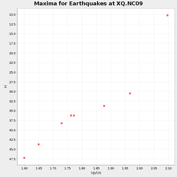
| Global Maxima | 36 km | 1.79 | 6.565 km/s | 3.662 km/s | 0.27 | amp=0.05976127 |
| Local Maxima 1 | 44 km | 1.65 | 6.565 km/s | 3.978 km/s | 0.21 | amp=0.0464013 |
| Local Maxima 2 | 30 km | 1.94 | 6.565 km/s | 3.379 km/s | 0.32 | amp=0.034989968 |
| Local Maxima 3 | 64 km | 1.69 | 6.565 km/s | 3.89 km/s | 0.23 | amp=0.016076496 |
| Local Maxima 4 | 45 km | 1.64 | 6.565 km/s | 3.991 km/s | 0.21 | amp=0.015879612 |
| Predicted Arrivals for vertical incidence (zero ray parameter) | |
| Ps | 4.32 SECOND |
| PpPs | 15.21 SECOND |
| PsPs/PpSs | 19.52 SECOND |
Events Processed for this Station
Download zip of receiver functions as SAC
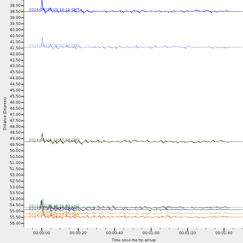
Plot maxima for each earthquake.
Events Used in the Stack
(8 events)| Radial Match | Distance | Baz | FERegion | Time | Lat/Lon | Depth | Magnitude |
| 96.69877 | 55.7 deg | 170.13 deg | Near Coast Of Northern Chile | 2014/03/16 21:16:30 GMT | (-19.9, -70.6) | 20 km | 6.7 MWW, 6.7 MWC, 7.0 MI |
| 96.57943 | 55.5 deg | 170.379 deg | Near Coast Of Northern Chile | 2014/03/22 12:59:59 GMT | (-19.8, -70.9) | 20 km | 6.2 MWW, 6.2 MWB, 6.3 MWC, 6.4 MWC |
| 92.64625 | 56.0 deg | 170.111 deg | Near Coast Of Northern Chile | 2014/04/03 01:58:31 GMT | (-20.3, -70.6) | 23 km | 6.5 MWW, 6.5 MWB, 6.6 MWC |
| 92.38192 | 37.6 deg | 307.716 deg | Vancouver Island, Canada Region | 2014/04/24 03:10:13 GMT | (49.8, -127.4) | 11 km | 6.7 MWP, 6.7 MI |
| 91.643616 | 56.3 deg | 170.378 deg | Near Coast Of Northern Chile | 2014/04/04 01:37:51 GMT | (-20.6, -70.7) | 20 km | 6.1 MWP, 6.1 MWB, 6.1 MWW, 6.3 MWC |
| 87.853645 | 40.8 deg | 182.549 deg | Near Coast Of Northern Peru | 2014/03/15 23:51:33 GMT | (-5.6, -81.0) | 29 km | 6.3 MWW, 6.2 MWB, 6.3 MWC |
| 80.775955 | 55.5 deg | 170.304 deg | Near Coast Of Northern Chile | 2014/03/23 18:20:03 GMT | (-19.7, -70.8) | 35 km | 6.0 MB, 6.2 MWB, 6.2 MWW, 6.3 MWC |
| 80.43804 | 49.5 deg | 175.301 deg | Near Coast Of Peru | 2014/02/18 23:35:58 GMT | (-14.2, -75.6) | 57 km | 6.0 MWB, 5.9 MWW, 5.9 MWC, 6.0 MWC |
Losers
(19 events)| Radial Match | Distance | Baz | FERegion | Time | Lat/Lon | Depth | Magnitude | Reason |
| 98.49577 | 56.3 deg | 170.091 deg | Near Coast Of Northern Chile | 2014/04/03 02:43:14 GMT | (-20.5, -70.5) | 31 km | 7.7 MWW, 7.4 MI, 7.7 MWC | |
| 98.357765 | 55.4 deg | 170.293 deg | Near Coast Of Northern Chile | 2014/04/01 23:46:46 GMT | (-19.6, -70.8) | 20 km | 8.2 MWW, 8.0 MI, 8.1 MWC | |
| 93.42058 | 36.1 deg | 292.591 deg | Off Coast Of Northern California | 2014/03/10 05:18:13 GMT | (40.8, -125.1) | 17 km | 6.8 MW, 6.8 MWR, 6.9 MWW, 6.9 MWB, 7.0 MI, 7.0 MWC | |
| 76.04727 | 55.7 deg | 170.49 deg | Near Coast Of Northern Chile | 2014/03/18 21:33:05 GMT | (-20.0, -70.9) | 6.3 km | 5.1 mb | |
| 74.01193 | 79.6 deg | 179.989 deg | Off Coast Of Southern Chile | 2014/01/07 12:06:13 GMT | (-44.5, -79.3) | 35 km | 5.2 MW | |
| 66.44988 | 55.9 deg | 170.44 deg | Near Coast Of Northern Chile | 2014/04/07 13:43:20 GMT | (-20.2, -70.9) | 7.9 km | 5.8 MWB, 5.7 MWW, 5.7 MWC | |
| 66.12554 | 56.5 deg | 170.282 deg | Near Coast Of Northern Chile | 2014/01/08 04:22:10 GMT | (-20.7, -70.6) | 20 km | 5.7 MWW, 5.6 MWB, 5.6 MWR, 5.7 MWC | |
| 64.59176 | 55.5 deg | 170.289 deg | Near Coast Of Northern Chile | 2014/03/24 11:32:15 GMT | (-19.8, -70.8) | 24 km | 5.3 MW | |
| 62.826912 | 63.8 deg | 318.414 deg | Fox Islands, Aleutian Islands | 2014/02/26 21:13:40 GMT | (53.6, -171.8) | 265 km | 6.1 MWW, 5.9 MI, 5.9 ML, 6.1 MWC, 6.1 MWB, 6.2 MWC | |
| 62.808754 | 49.4 deg | 176.197 deg | Near Coast Of Peru | 2014/03/15 08:59:21 GMT | (-14.1, -76.3) | 20 km | 6.1 MWW, 6.0 MWB, 6.2 MWC | |
| 62.485897 | 55.1 deg | 332.414 deg | Northern Alaska | 2014/05/03 08:57:12 GMT | (67.6, -162.2) | 0.9 km | 5.5 MB | |
| 60.912075 | 56.3 deg | 162.498 deg | Southern Bolivia | 2014/01/27 16:42:37 GMT | (-19.3, -63.9) | 600 km | 5.6 MWB | |
| 59.850487 | 56.5 deg | 170.281 deg | Near Coast Of Northern Chile | 2014/01/06 03:59:02 GMT | (-20.7, -70.6) | 27 km | 5.2 MW | |
| 59.081154 | 55.3 deg | 170.286 deg | Near Coast Of Northern Chile | 2014/03/24 15:45:31 GMT | (-19.6, -70.8) | 18 km | 5.6 MWB, 5.5 MWR, 5.7 MWC, 5.7 MWW | |
| 58.958317 | 56.3 deg | 170.331 deg | Near Coast Of Northern Chile | 2014/04/03 09:23:21 GMT | (-20.6, -70.7) | 15 km | 5.6 MB, 5.3 MWR | |
| 58.645313 | 68.9 deg | 318.346 deg | Andreanof Islands, Aleutian Is. | 2014/01/16 07:33:09 GMT | (51.2, -179.2) | 27 km | 5.5 MWB, 5.2 ML, 5.5 ML, 5.6 MWC | |
| 49.51506 | 74.0 deg | 198.315 deg | Southeast Of Easter Island | 2014/04/15 13:31:33 GMT | (-36.1, -101.2) | 14 km | 5.6 MW | |
| 46.45273 | 81.0 deg | 178.097 deg | Off Coast Of Southern Chile | 2014/03/02 16:18:30 GMT | (-45.9, -76.6) | 23 km | 5.0 MW | |
| 46.293255 | 55.3 deg | 169.528 deg | Near Coast Of Northern Chile | 2014/04/01 23:59:57 GMT | (-19.5, -70.2) | 22 km | 5.8 MB |

