
Station XQ NC10 - NC10
Network: XQ12 - Pre-Hydrofracking Regional Assessment of Central Carolina Seismicity
Nearby stations (2 deg radius)

| Station | Name | (Lat, Lon) | Start / End | Elevation |
| NC10 | NC10 | (35.47, -79.22) | 2012-03-25 / 2014-12-31 | 123 m |
| Crust2 Type: | DG,thin Platform 1 km seds. |
| Thickness Estimate: | 33 km |
| Thickness StdDev: | 1.2 km |
| Vp/Vs Estimate: | 1.82 |
| Vp/Vs StdDev: | 0.04 |
| Vs Estimate: | 3.617 km/s |
| Poisson's Ratio: | 0.28 |
| Peak Value: | 0.07 |
| Assumed Vp: | 6.565 km/s |
| Ps Weight: | 0.33333334 |
| PpPs Weight: | 0.33333334 |
| PsPs Weight: | 0.33333328 |
| Residual Complexity: | 0.400 |
| Nearby stations H: | +- |
| (2.0 deg) Vp/Vs: | +- |
5 with match > 90% ( 17.857143 %) and 6 with match > 80% ( 21.428572 %) out of 28.
Download stack as xyz text file.
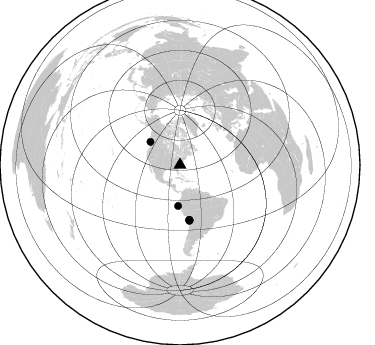
Azimuth Distribution of Events:
Prior Results for this Station
| Study | Thickness | Vp/Vs | Vp | Vs | Poissons Ratio | Extra |
| EARS | 33 km | 1.82 | 6.565 km/s | 3.617 km/s | 0.28 | |
| Crust2.0 | 31 km | 1.78 | 6.565 km/s | 3.684 km/s | 0.27 | DG,thin Platform 1 km seds. |
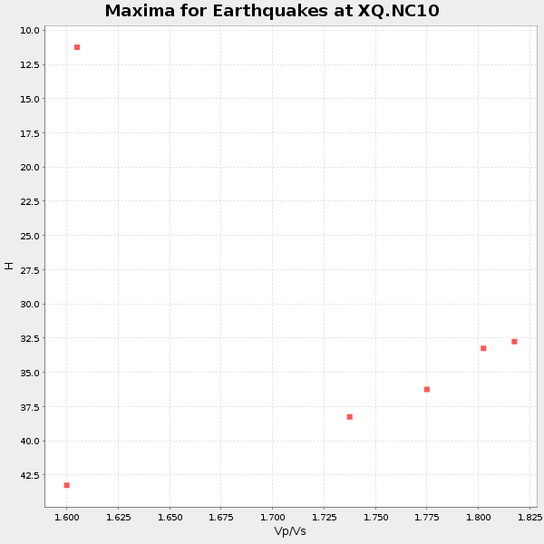
| Global Maxima | 33 km | 1.82 | 6.565 km/s | 3.617 km/s | 0.28 | amp=0.07025594 |
| Local Maxima 1 | 44 km | 1.60 | 6.565 km/s | 4.103 km/s | 0.18 | amp=0.038826175 |
| Local Maxima 2 | 46 km | 1.62 | 6.565 km/s | 4.058 km/s | 0.19 | amp=0.023628771 |
| Local Maxima 3 | 37 km | 1.75 | 6.565 km/s | 3.762 km/s | 0.26 | amp=0.012140497 |
| Local Maxima 4 | 25 km | 2.10 | 6.565 km/s | 3.13 km/s | 0.35 | amp=0.009886171 |
| Predicted Arrivals for vertical incidence (zero ray parameter) | |
| Ps | 4.07 SECOND |
| PpPs | 14.04 SECOND |
| PsPs/PpSs | 18.11 SECOND |
Events Processed for this Station
Download zip of receiver functions as SAC
Plot maxima for each earthquake.
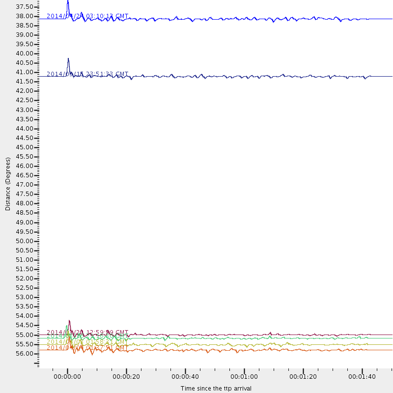
Events Used in the Stack
(6 events)| Radial Match | Distance | Baz | FERegion | Time | Lat/Lon | Depth | Magnitude |
| 96.83856 | 55.5 deg | 170.454 deg | Near Coast Of Northern Chile | 2014/03/22 12:59:59 GMT | (-19.8, -70.9) | 20 km | 6.2 MWW, 6.2 MWB, 6.3 MWC, 6.4 MWC |
| 95.6078 | 55.7 deg | 170.204 deg | Near Coast Of Northern Chile | 2014/03/16 21:16:30 GMT | (-19.9, -70.6) | 20 km | 6.7 MWW, 6.7 MWC, 7.0 MI |
| 93.34095 | 56.0 deg | 170.185 deg | Near Coast Of Northern Chile | 2014/04/03 01:58:31 GMT | (-20.3, -70.6) | 23 km | 6.5 MWW, 6.5 MWB, 6.6 MWC |
| 92.23545 | 37.6 deg | 307.689 deg | Vancouver Island, Canada Region | 2014/04/24 03:10:13 GMT | (49.8, -127.4) | 11 km | 6.7 MWP, 6.7 MI |
| 90.521164 | 40.9 deg | 182.645 deg | Near Coast Of Northern Peru | 2014/03/15 23:51:33 GMT | (-5.6, -81.0) | 29 km | 6.3 MWW, 6.2 MWB, 6.3 MWC |
| 87.84458 | 56.4 deg | 170.451 deg | Near Coast Of Northern Chile | 2014/04/04 01:37:51 GMT | (-20.6, -70.7) | 20 km | 6.1 MWP, 6.1 MWB, 6.1 MWW, 6.3 MWC |
Losers
(22 events)| Radial Match | Distance | Baz | FERegion | Time | Lat/Lon | Depth | Magnitude | Reason |
| 98.57389 | 55.4 deg | 170.368 deg | Near Coast Of Northern Chile | 2014/04/01 23:46:46 GMT | (-19.6, -70.8) | 20 km | 8.2 MWW, 8.0 MI, 8.1 MWC | |
| 98.3351 | 56.3 deg | 170.164 deg | Near Coast Of Northern Chile | 2014/04/03 02:43:14 GMT | (-20.5, -70.5) | 31 km | 7.7 MWW, 7.4 MI, 7.7 MWC | |
| 91.80905 | 36.2 deg | 292.574 deg | Off Coast Of Northern California | 2014/03/10 05:18:13 GMT | (40.8, -125.1) | 17 km | 6.8 MW, 6.8 MWR, 6.9 MWW, 6.9 MWB, 7.0 MI, 7.0 MWC | |
| 78.90977 | 55.5 deg | 170.379 deg | Near Coast Of Northern Chile | 2014/03/23 18:20:03 GMT | (-19.7, -70.8) | 35 km | 6.0 MB, 6.2 MWB, 6.2 MWW, 6.3 MWC | |
| 74.286354 | 49.5 deg | 175.384 deg | Near Coast Of Peru | 2014/02/18 23:35:58 GMT | (-14.2, -75.6) | 57 km | 6.0 MWB, 5.9 MWW, 5.9 MWC, 6.0 MWC | |
| 69.3688 | 63.8 deg | 318.424 deg | Fox Islands, Aleutian Islands | 2014/02/26 21:13:40 GMT | (53.6, -171.8) | 265 km | 6.1 MWW, 5.9 MI, 5.9 ML, 6.1 MWC, 6.1 MWB, 6.2 MWC | |
| 68.52576 | 49.4 deg | 176.28 deg | Near Coast Of Peru | 2014/03/15 08:59:21 GMT | (-14.1, -76.3) | 20 km | 6.1 MWW, 6.0 MWB, 6.2 MWC | |
| 67.92537 | 71.1 deg | 105.639 deg | North Of Ascension Island | 2014/04/30 15:52:42 GMT | (-1.2, -13.5) | 14 km | 5.8 MW | |
| 66.34153 | 97.2 deg | 153.674 deg | South Georgia Island Region | 2014/03/17 13:24:48 GMT | (-53.2, -32.3) | 5.4 km | 5.6 MB, 5.8 MWB, 5.9 MWC | |
| 65.889565 | 90.7 deg | 37.097 deg | Eastern Caucasus | 2014/02/10 12:06:46 GMT | (40.3, 48.8) | 63 km | 5.5 MW | |
| 57.106094 | 93.8 deg | 333.109 deg | Eastern Sea Of Japan | 2014/01/11 03:56:48 GMT | (43.7, 139.2) | 230 km | 5.0 MW | |
| 57.042465 | 63.5 deg | 52.815 deg | France | 2014/04/07 19:27:00 GMT | (44.5, 6.7) | 9.1 km | 5.0 MW | |
| 56.225487 | 55.9 deg | 170.514 deg | Near Coast Of Northern Chile | 2014/04/07 13:43:20 GMT | (-20.2, -70.9) | 7.9 km | 5.8 MWB, 5.7 MWW, 5.7 MWC | |
| 55.50993 | 86.5 deg | 327.084 deg | Kuril Islands | 2014/01/06 07:27:20 GMT | (46.2, 152.1) | 100 km | 3.5 mb | |
| 55.199116 | 55.1 deg | 332.412 deg | Northern Alaska | 2014/05/03 08:57:12 GMT | (67.6, -162.2) | 0.9 km | 5.5 MB | |
| 54.907253 | 65.0 deg | 354.741 deg | East Of Severnaya Zemlya | 2014/01/14 03:43:05 GMT | (78.8, 126.0) | 10 km | 4.1 mb | |
| 53.454353 | 56.3 deg | 170.405 deg | Near Coast Of Northern Chile | 2014/04/03 09:23:21 GMT | (-20.6, -70.7) | 15 km | 5.6 MB, 5.3 MWR | |
| 50.81306 | 56.1 deg | 170.663 deg | Near Coast Of Northern Chile | 2014/04/06 14:06:09 GMT | (-20.4, -71.0) | 20 km | 5.3 MW | |
| 48.283672 | 68.9 deg | 318.362 deg | Andreanof Islands, Aleutian Is. | 2014/01/16 07:33:09 GMT | (51.2, -179.2) | 27 km | 5.5 MWB, 5.2 ML, 5.5 ML, 5.6 MWC | |
| 47.156914 | 55.3 deg | 169.604 deg | Near Coast Of Northern Chile | 2014/04/01 23:59:57 GMT | (-19.5, -70.2) | 22 km | 5.8 MB | |
| 43.489895 | 56.3 deg | 162.572 deg | Southern Bolivia | 2014/01/27 16:42:37 GMT | (-19.3, -63.9) | 600 km | 5.6 MWB | |
| 36.600697 | 59.9 deg | 169.41 deg | Northern Chile | 2014/03/20 18:41:32 GMT | (-24.0, -69.2) | 96 km | 5.1 MW |

