
Station XQ NA330 - Katmandu,Nepal
Network: XQ15 - Rapid response to the Mw 7.9 earthquake of April 25, 2015 in Nepal
Nearby stations (2 deg radius)
| Station | Name | (Lat, Lon) | Start / End | Elevation |
| NA330 | Katmandu,Nepal | (27.59, 84.70) | 2015-06-29 / 2016-05-11 | 251 m |
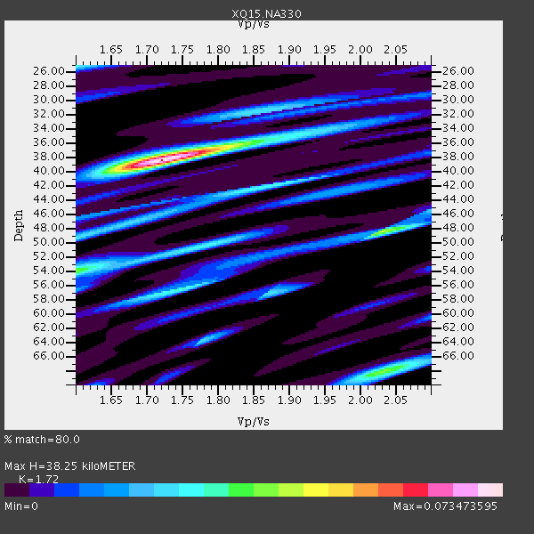
| Crust2 Type: | P9,orogen/50km, Rockies, 4 km seds. |
| Thickness Estimate: | 38 km |
| Thickness StdDev: | 5.3 km |
| Vp/Vs Estimate: | 1.72 |
| Vp/Vs StdDev: | 0.05 |
| Vs Estimate: | 3.571 km/s |
| Poisson's Ratio: | 0.24 |
| Peak Value: | 0.07 |
| Assumed Vp: | 6.142 km/s |
| Ps Weight: | 0.33333334 |
| PpPs Weight: | 0.33333334 |
| PsPs Weight: | 0.33333328 |
| Residual Complexity: | 0.662 |
| Nearby stations H: | +- |
| (2.0 deg) Vp/Vs: | +- |
0 with match > 90% ( 0.0 %) and 2 with match > 80% ( 16.666666 %) out of 12.
Download stack as xyz text file.
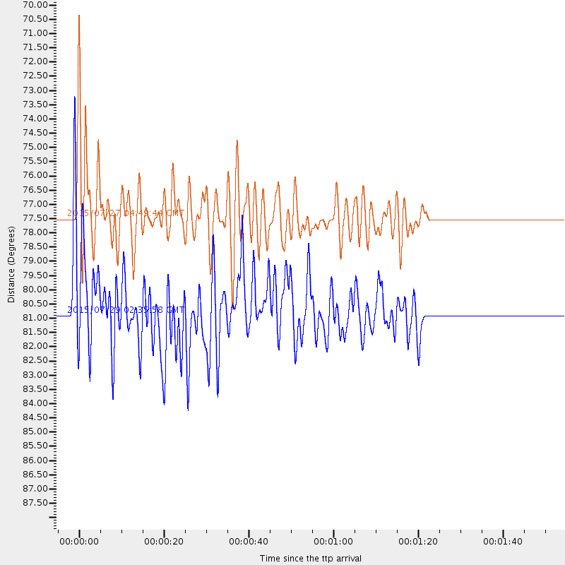
Azimuth Distribution of Events:

Prior Results for this Station
| Study | Thickness | Vp/Vs | Vp | Vs | Poissons Ratio | Extra |
| EARS | 38 km | 1.72 | 6.142 km/s | 3.571 km/s | 0.24 | |
| Crust2.0 | 50 km | 1.76 | 6.142 km/s | 3.486 km/s | 0.26 | P9,orogen/50km, Rockies, 4 km seds. |
| Global Maxima | 38 km | 1.72 | 6.142 km/s | 3.571 km/s | 0.24 | amp=0.073473595 |
| Local Maxima 1 | 48 km | 2.03 | 6.142 km/s | 3.026 km/s | 0.34 | amp=0.040911283 |
| Local Maxima 2 | 68 km | 2.03 | 6.142 km/s | 3.029 km/s | 0.34 | amp=0.037812106 |
| Local Maxima 3 | 54 km | 1.60 | 6.142 km/s | 3.839 km/s | 0.18 | amp=0.037209176 |
| Local Maxima 4 | 56 km | 1.75 | 6.142 km/s | 3.51 km/s | 0.26 | amp=0.029585533 |
| Predicted Arrivals for vertical incidence (zero ray parameter) | |
| Ps | 4.48 SECOND |
| PpPs | 16.94 SECOND |
| PsPs/PpSs | 21.42 SECOND |
Events Processed for this Station
Download zip of receiver functions as SAC
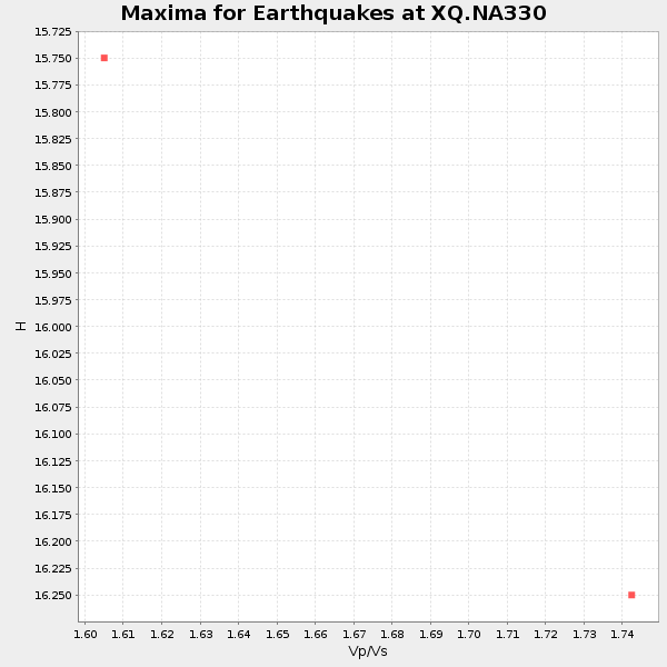
Plot maxima for each earthquake.
Events Used in the Stack
(2 events)| Radial Match | Distance | Baz | FERegion | Time | Lat/Lon | Depth | Magnitude |
| 88.61674 | 77.5 deg | 37.213 deg | Fox Islands, Aleutian Islands | 2015/07/27 04:49:44 GMT | (52.4, -169.7) | 12 km | 6.9 MO |
| 80.16457 | 80.8 deg | 25.59 deg | Southern Alaska | 2015/07/29 02:35:58 GMT | (59.9, -153.1) | 118 km | 6.3 ML, 6.2 MWP, 6.2 MI, 6.3 MWW |
Losers
(10 events)| Radial Match | Distance | Baz | FERegion | Time | Lat/Lon | Depth | Magnitude | Reason |
| 89.85235 | 52.6 deg | 54.217 deg | Kuril Islands | 2015/07/07 05:10:27 GMT | (44.0, 147.9) | 38 km | 6.3 MO | |
| 88.806625 | 86.5 deg | 103.609 deg | Santa Cruz Islands | 2015/07/18 02:27:33 GMT | (-10.4, 165.2) | 10 km | 7.0 MWW, 7.5 MI | |
| 83.26589 | 48.0 deg | 59.284 deg | Near East Coast Of Honshu, Japan | 2015/07/09 18:32:51 GMT | (40.4, 141.5) | 79 km | 5.6 MWB, 5.5 MWW, 5.6 MWR, 5.6 MWC | |
| 83.05444 | 59.8 deg | 111.242 deg | Irian Jaya, Indonesia | 2015/07/27 21:41:22 GMT | (-2.7, 138.5) | 53 km | 7.0 MWP, 7.0 MI | |
| 82.72054 | 80.1 deg | 105.914 deg | Solomon Islands | 2015/07/10 04:12:41 GMT | (-9.3, 158.4) | 10 km | 6.7 MWW, 6.6 MWB, 6.7 MWC, 7.0 MI | |
| 65.17847 | 52.7 deg | 52.871 deg | Kuril Islands | 2015/07/03 07:07:08 GMT | (45.1, 148.1) | 162 km | 4.4 mb | |
| 61.010445 | 40.2 deg | 103.186 deg | Samar, Philippines | 2015/07/25 08:41:09 GMT | (12.8, 124.8) | 71 km | 4.9 MW | |
| 45.622074 | 48.0 deg | 57.016 deg | Hokkaido, Japan Region | 2015/07/03 03:33:27 GMT | (42.1, 141.6) | 102 km | 4.5 mb | |
| 44.21433 | 48.1 deg | 56.217 deg | Hokkaido, Japan Region | 2015/07/15 21:14:09 GMT | (42.6, 141.7) | 129 km | 4.4 mb | |
| 34.063934 | 72.4 deg | 106.374 deg | New Britain Region, P.N.G. | 2015/07/07 16:41:35 GMT | (-5.7, 151.5) | 57 km | 4.9 mb |

