
Station XR FA01 - fled station 1
Network: XR01 - Florida to Edmonton Seismic Experiment
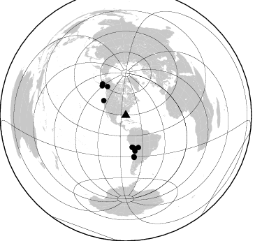
Nearby stations (2 deg radius)
| Station | Name | (Lat, Lon) | Start / End | Elevation |
| FA01 | fled station 1 | (29.92, -82.58) | 2001-05-17 / 2002-12-31 | -0.0 km |
| Crust2 Type: | C4,continental shelf, 3.5 km seds. |
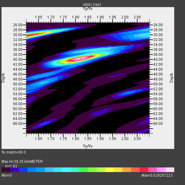
| Thickness Estimate: | 39 km |
| Thickness StdDev: | 4.7 km |
| Vp/Vs Estimate: | 1.82 |
| Vp/Vs StdDev: | 0.10 |
| Vs Estimate: | 3.291 km/s |
| Poisson's Ratio: | 0.28 |
| Peak Value: | 0.03 |
| Assumed Vp: | 5.989 km/s |
| Ps Weight: | 0.33333334 |
| PpPs Weight: | 0.33333334 |
| PsPs Weight: | 0.33333328 |
| Residual Complexity: | 0.595 |
| Nearby stations H: | +- |
| (2.0 deg) Vp/Vs: | +- |
7 with match > 90% ( 63.636364 %) and 11 with match > 80% ( 100.0 %) out of 11.
Download stack as xyz text file.
Azimuth Distribution of Events:
Prior Results for this Station
| Study | Thickness | Vp/Vs | Vp | Vs | Poissons Ratio | Extra |
| EARS | 39 km | 1.82 | 5.989 km/s | 3.291 km/s | 0.28 | |
| Crust2.0 | 32 km | 1.81 | 5.989 km/s | 3.317 km/s | 0.28 | C4,continental shelf, 3.5 km seds. |
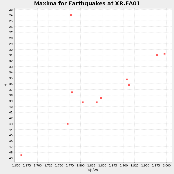
| Global Maxima | 39 km | 1.82 | 5.989 km/s | 3.291 km/s | 0.28 | amp=0.029257223 |
| Local Maxima 1 | 30 km | 1.61 | 5.989 km/s | 3.714 km/s | 0.19 | amp=0.024679229 |
| Local Maxima 2 | 40 km | 1.81 | 5.989 km/s | 3.318 km/s | 0.28 | amp=0.01040916 |
| Local Maxima 3 | 29 km | 2.10 | 5.989 km/s | 2.855 km/s | 0.35 | amp=0.008941452 |
| Local Maxima 4 | 28 km | 2.10 | 5.989 km/s | 2.855 km/s | 0.35 | amp=0.006028147 |
| Predicted Arrivals for vertical incidence (zero ray parameter) | |
| Ps | 5.37 SECOND |
| PpPs | 18.48 SECOND |
| PsPs/PpSs | 23.86 SECOND |
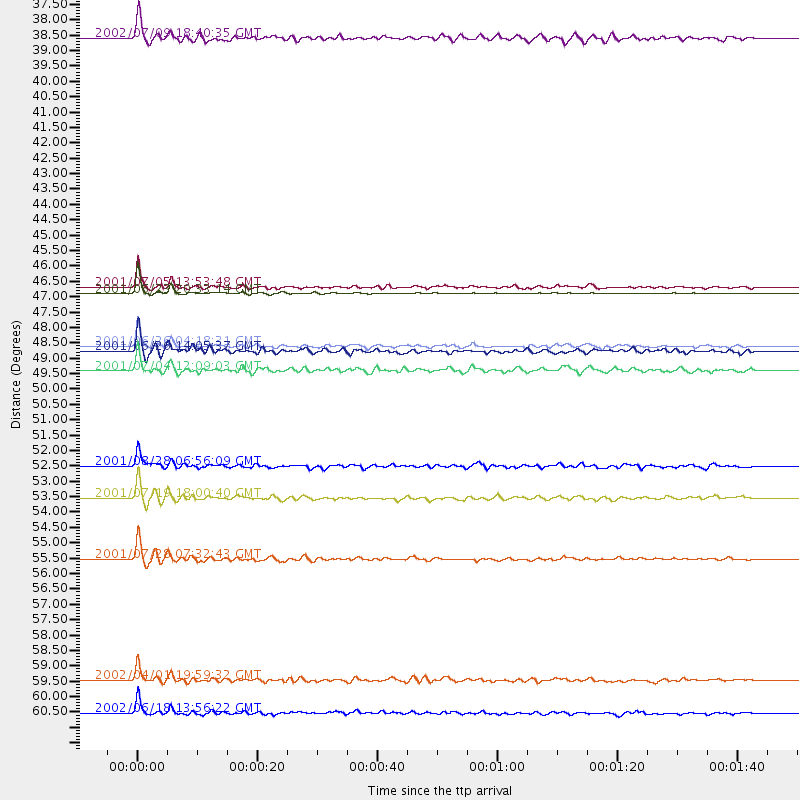
Events Processed for this Station
Download zip of receiver functions as SAC
Plot maxima for each earthquake.
Events Used in the Stack
(11 events)| Radial Match | Distance | Baz | FERegion | Time | Lat/Lon | Depth | Magnitude |
| 98.94269 | 46.7 deg | 168.166 deg | Near Coast Of Peru | 2001/06/23 20:33:14 GMT | (-16.3, -73.6) | 33 km | 6.7 MB, 8.2 MS, 8.4 MW, 7.8 ME |
| 97.02038 | 46.5 deg | 168.571 deg | Near Coast Of Peru | 2001/07/05 13:53:48 GMT | (-16.1, -74.0) | 62 km | 6.2 MB, 6.6 MW, 6.5 ME |
| 95.44672 | 48.5 deg | 166.043 deg | Near Coast Of Peru | 2001/06/26 04:18:31 GMT | (-17.7, -71.6) | 24 km | 6.2 MB, 6.7 MS, 6.8 MW, 6.7 ME |
| 95.261604 | 56.0 deg | 323.47 deg | Southern Alaska | 2001/07/28 07:32:43 GMT | (59.0, -155.1) | 131 km | 5.7 MB, 5.7 MS, 6.6 MW, 6.2 ME |
| 95.210686 | 61.4 deg | 168.769 deg | Near Coast Of Central Chile | 2002/06/18 13:56:22 GMT | (-30.8, -71.1) | 54 km | 6.0 MB, 6.6 MW, 6.4 MW |
| 91.7021 | 53.9 deg | 321.181 deg | Kodiak Island Region, Alaska | 2001/07/19 18:00:40 GMT | (57.2, -151.0) | 33 km | 5.9 MB, 5.4 MS, 5.9 MW, 5.9 ML |
| 90.803535 | 60.2 deg | 168.769 deg | Near Coast Of Central Chile | 2002/04/01 19:59:32 GMT | (-29.7, -71.4) | 71 km | 6.1 MB, 6.4 MW, 6.4 MW |
| 88.82049 | 48.7 deg | 327.251 deg | Southern Yukon Territory, Canada | 2001/06/26 14:05:37 GMT | (61.3, -140.1) | 10 km | 5.8 MB, 5.4 MS, 6.0 ML, 5.8 MW |
| 88.16378 | 49.4 deg | 158.547 deg | Central Bolivia | 2001/07/04 12:09:03 GMT | (-17.0, -65.7) | 33 km | 5.6 MB, 5.9 MS, 6.1 MW, 6.1 MW |
| 84.16666 | 37.8 deg | 303.549 deg | Off Coast Of Oregon | 2002/07/09 18:40:35 GMT | (43.5, -127.2) | 10 km | 5.5 MB, 5.5 MS, 6.0 MW, 5.8 MW |
| 80.93849 | 52.7 deg | 165.38 deg | Near Coast Of Northern Chile | 2001/08/28 06:56:09 GMT | (-21.7, -70.1) | 66 km | 5.8 MB, 5.9 MW, 5.8 MW |
Losers
(0 events)| Radial Match | Distance | Baz | FERegion | Time | Lat/Lon | Depth | Magnitude | Reason |
