
Station XR FA05 - fled station 5
Network: XR01 - Florida to Edmonton Seismic Experiment
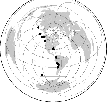
Nearby stations (2 deg radius)
| Station | Name | (Lat, Lon) | Start / End | Elevation |
| FA05 | fled station 5 | (33.57, -85.11) | 2001-05-15 / 2002-12-31 | 0.3 km |
| Crust2 Type: | E2,thin Platform 0.0 km seds. |
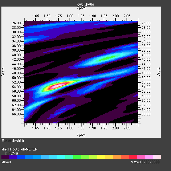
| Thickness Estimate: | 54 km |
| Thickness StdDev: | 5.7 km |
| Vp/Vs Estimate: | 1.75 |
| Vp/Vs StdDev: | 0.05 |
| Vs Estimate: | 3.851 km/s |
| Poisson's Ratio: | 0.26 |
| Peak Value: | 0.02 |
| Assumed Vp: | 6.719 km/s |
| Ps Weight: | 0.33333334 |
| PpPs Weight: | 0.33333334 |
| PsPs Weight: | 0.33333328 |
| Residual Complexity: | 0.589 |
| Nearby stations H: | +- |
| (2.0 deg) Vp/Vs: | +- |
8 with match > 90% ( 61.53846 %) and 13 with match > 80% ( 100.0 %) out of 13.
Download stack as xyz text file.
Azimuth Distribution of Events:
Prior Results for this Station
| Study | Thickness | Vp/Vs | Vp | Vs | Poissons Ratio | Extra |
| EARS | 54 km | 1.75 | 6.719 km/s | 3.851 km/s | 0.26 | |
| Crust2.0 | 31 km | 1.78 | 6.719 km/s | 3.774 km/s | 0.27 | E2,thin Platform 0.0 km seds. |
| Global Maxima | 54 km | 1.75 | 6.719 km/s | 3.851 km/s | 0.26 | amp=0.020573588 |
| Local Maxima 1 | 42 km | 1.96 | 6.719 km/s | 3.433 km/s | 0.32 | amp=0.00950733 |
| Local Maxima 2 | 52 km | 1.74 | 6.719 km/s | 3.856 km/s | 0.25 | amp=0.007008563 |
| Local Maxima 3 | 34 km | 1.60 | 6.719 km/s | 4.2 km/s | 0.18 | amp=0.005431255 |
| Local Maxima 4 | 27 km | 1.71 | 6.719 km/s | 3.941 km/s | 0.24 | amp=0.0046407008 |
| Predicted Arrivals for vertical incidence (zero ray parameter) | |
| Ps | 5.93 SECOND |
| PpPs | 21.86 SECOND |
| PsPs/PpSs | 27.79 SECOND |
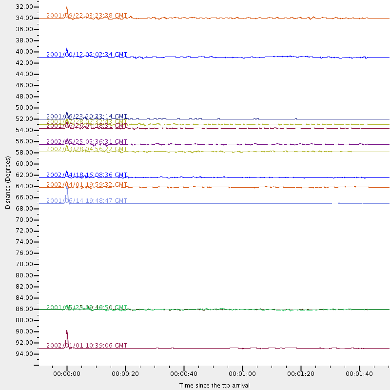
Events Processed for this Station
Download zip of receiver functions as SAC
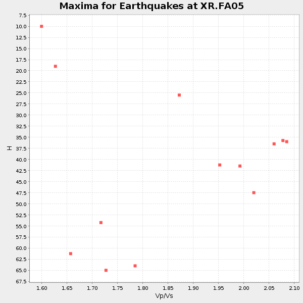
Plot maxima for each earthquake.
Events Used in the Stack
(13 events)| Radial Match | Distance | Baz | FERegion | Time | Lat/Lon | Depth | Magnitude |
| 99.61739 | 67.4 deg | 317.174 deg | Andreanof Islands, Aleutian Is. | 2001/06/14 19:48:47 GMT | (51.2, -179.8) | 18 km | 6.0 MB, 6.3 MS, 6.5 MW, 6.1 ML |
| 98.89621 | 50.8 deg | 165.724 deg | Near Coast Of Peru | 2001/06/23 20:33:14 GMT | (-16.3, -73.6) | 33 km | 6.7 MB, 8.2 MS, 8.4 MW, 7.8 ME |
| 97.78731 | 96.1 deg | 203.552 deg | Pacific-Antarctic Ridge | 2002/01/01 10:39:06 GMT | (-55.2, -129.0) | 10 km | 5.2 MB, 5.5 MS, 6.0 MW, 6.0 MW |
| 97.25656 | 52.6 deg | 163.79 deg | Near Coast Of Peru | 2001/06/26 04:18:31 GMT | (-17.7, -71.6) | 24 km | 6.2 MB, 6.7 MS, 6.8 MW, 6.7 ME |
| 95.491646 | 57.2 deg | 161.37 deg | Chile-Bolivia Border Region | 2002/03/28 04:56:22 GMT | (-21.7, -68.3) | 125 km | 6.1 MB, 6.5 MW, 6.5 MW |
| 94.486244 | 62.3 deg | 165.435 deg | Near Coast Of Northern Chile | 2002/04/18 16:08:36 GMT | (-27.5, -70.6) | 62 km | 6.2 MB, 6.7 MW, 6.6 MW |
| 92.82366 | 88.5 deg | 324.709 deg | Kuril Islands | 2001/05/25 00:40:50 GMT | (44.3, 148.4) | 33 km | 6.1 MB, 6.7 MS, 6.7 MW, 6.6 MW |
| 92.28161 | 51.8 deg | 321.781 deg | Southern Alaska | 2001/07/28 07:32:43 GMT | (59.0, -155.1) | 131 km | 5.7 MB, 5.7 MS, 6.6 MW, 6.2 ME |
| 89.387955 | 55.7 deg | 315.881 deg | South Of Alaska | 2002/05/25 05:36:31 GMT | (53.8, -161.1) | 33 km | 5.5 MB, 6.1 MS, 6.5 MW, 6.4 MW |
| 83.09356 | 38.5 deg | 314.154 deg | Queen Charlotte Islands Region | 2001/10/12 05:02:34 GMT | (52.6, -132.2) | 20 km | 5.6 MB, 5.8 MS, 6.2 MW, 6.1 MW |
| 82.89811 | 88.5 deg | 324.594 deg | Kuril Islands | 2001/06/24 13:18:51 GMT | (44.2, 148.5) | 33 km | 5.8 MB, 5.7 MS, 6.0 MW |
| 82.45984 | 30.8 deg | 161.942 deg | Colombia | 2001/09/22 03:23:38 GMT | (3.9, -76.0) | 179 km | 6.0 MB, 6.0 MW, 6.0 MW |
| 80.556625 | 64.2 deg | 166.744 deg | Near Coast Of Central Chile | 2002/04/01 19:59:32 GMT | (-29.7, -71.4) | 71 km | 6.1 MB, 6.4 MW, 6.4 MW |
Losers
(0 events)| Radial Match | Distance | Baz | FERegion | Time | Lat/Lon | Depth | Magnitude | Reason |
