
Station XR FA07 - fled station 7
Network: XR01 - Florida to Edmonton Seismic Experiment
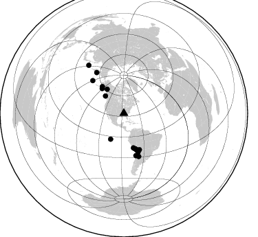
Nearby stations (2 deg radius)
| Station | Name | (Lat, Lon) | Start / End | Elevation |
| FA07 | fled station 7 | (34.73, -86.71) | 2001-05-11 / 2002-12-31 | 0.2 km |
| Crust2 Type: | Q6,orogen/41.5km no ice, cordilleras, 1.5 km seds. |
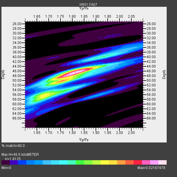
| Thickness Estimate: | 46 km |
| Thickness StdDev: | 2.7 km |
| Vp/Vs Estimate: | 1.81 |
| Vp/Vs StdDev: | 0.04 |
| Vs Estimate: | 3.573 km/s |
| Poisson's Ratio: | 0.28 |
| Peak Value: | 0.02 |
| Assumed Vp: | 6.476 km/s |
| Ps Weight: | 0.33333334 |
| PpPs Weight: | 0.33333334 |
| PsPs Weight: | 0.33333328 |
| Residual Complexity: | 0.602 |
| Nearby stations H: | +- |
| (2.0 deg) Vp/Vs: | +- |
13 with match > 90% ( 72.22222 %) and 18 with match > 80% ( 100.0 %) out of 18.
Download stack as xyz text file.
Azimuth Distribution of Events:
Prior Results for this Station
| Study | Thickness | Vp/Vs | Vp | Vs | Poissons Ratio | Extra |
| EARS | 46 km | 1.81 | 6.476 km/s | 3.573 km/s | 0.28 | |
| Crust2.0 | 42 km | 1.76 | 6.476 km/s | 3.675 km/s | 0.26 | Q6,orogen/41.5km no ice, cordilleras, 1.5 km seds. |
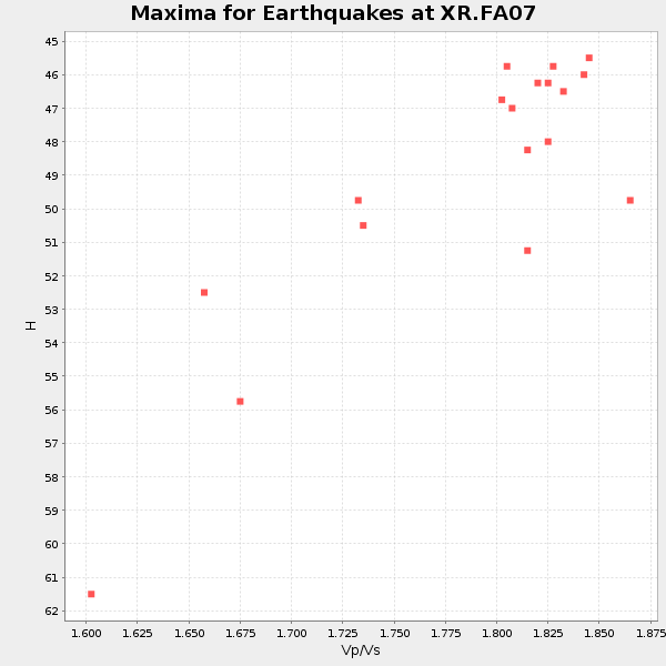
| Global Maxima | 46 km | 1.81 | 6.476 km/s | 3.573 km/s | 0.28 | amp=0.02167479 |
| Local Maxima 1 | 50 km | 1.75 | 6.476 km/s | 3.711 km/s | 0.26 | amp=0.012435741 |
| Local Maxima 2 | 54 km | 1.78 | 6.476 km/s | 3.643 km/s | 0.27 | amp=0.009691902 |
| Local Maxima 3 | 44 km | 1.87 | 6.476 km/s | 3.458 km/s | 0.30 | amp=0.007248293 |
| Local Maxima 4 | 50 km | 1.72 | 6.476 km/s | 3.76 km/s | 0.25 | amp=0.005908391 |
| Predicted Arrivals for vertical incidence (zero ray parameter) | |
| Ps | 5.83 SECOND |
| PpPs | 20.20 SECOND |
| PsPs/PpSs | 26.03 SECOND |
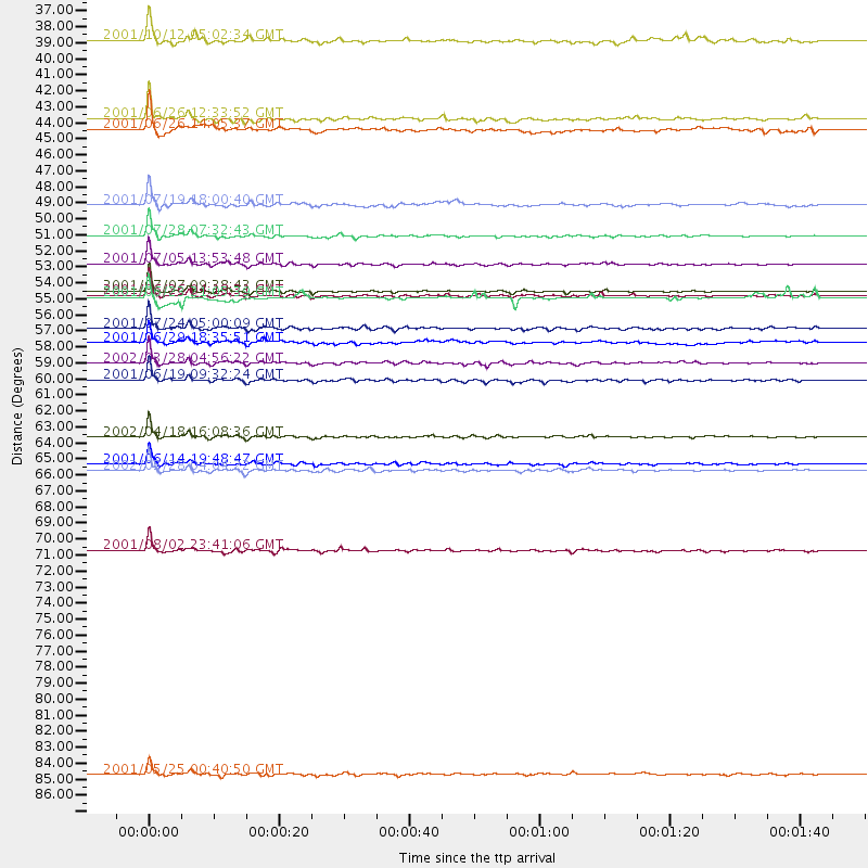
Events Processed for this Station
Download zip of receiver functions as SAC
Plot maxima for each earthquake.
Events Used in the Stack
(18 events)| Radial Match | Distance | Baz | FERegion | Time | Lat/Lon | Depth | Magnitude |
| 98.17983 | 52.0 deg | 164.406 deg | Near Coast Of Peru | 2001/07/05 13:53:48 GMT | (-16.1, -74.0) | 62 km | 6.2 MB, 6.6 MW, 6.5 ME |
| 97.33736 | 53.8 deg | 162.625 deg | Near Coast Of Peru | 2001/07/07 09:38:43 GMT | (-17.5, -72.1) | 33 km | 6.6 MB, 7.3 MS, 7.6 MW, 7.5 ME |
| 97.315216 | 54.1 deg | 162.202 deg | Near Coast Of Peru | 2001/06/26 04:18:31 GMT | (-17.7, -71.6) | 24 km | 6.2 MB, 6.7 MS, 6.8 MW, 6.7 ME |
| 96.623566 | 71.5 deg | 326.313 deg | Near East Coast Of Kamchatka | 2001/08/02 23:41:06 GMT | (56.3, 163.8) | 14 km | 5.9 MB, 6.2 MS, 6.3 MW, 6.2 ME |
| 96.389404 | 50.0 deg | 321.145 deg | Southern Alaska | 2001/07/28 07:32:43 GMT | (59.0, -155.1) | 131 km | 5.7 MB, 5.7 MS, 6.6 MW, 6.2 ME |
| 96.13232 | 86.8 deg | 323.831 deg | Kuril Islands | 2001/05/25 00:40:50 GMT | (44.3, 148.4) | 33 km | 6.1 MB, 6.7 MS, 6.7 MW, 6.6 MW |
| 96.01396 | 66.1 deg | 160.935 deg | Catamarca Province, Argentina | 2002/05/28 04:04:22 GMT | (-28.9, -66.8) | 22 km | 6.0 MB, 5.7 MS, 6.0 MW, 5.9 MW |
| 95.80203 | 58.7 deg | 159.931 deg | Chile-Bolivia Border Region | 2002/03/28 04:56:22 GMT | (-21.7, -68.3) | 125 km | 6.1 MB, 6.5 MW, 6.5 MW |
| 94.60258 | 65.6 deg | 316.355 deg | Andreanof Islands, Aleutian Is. | 2001/06/14 19:48:47 GMT | (51.2, -179.8) | 18 km | 6.0 MB, 6.3 MS, 6.5 MW, 6.1 ML |
| 93.36931 | 63.8 deg | 164.044 deg | Near Coast Of Northern Chile | 2002/04/18 16:08:36 GMT | (-27.5, -70.6) | 62 km | 6.2 MB, 6.7 MW, 6.6 MW |
| 91.5242 | 56.4 deg | 160.128 deg | Northern Chile | 2001/07/24 05:00:09 GMT | (-19.4, -69.3) | 33 km | 5.7 MB, 6.2 MS, 6.3 MW, 6.3 MW |
| 91.32235 | 59.9 deg | 159.848 deg | Chile-Bolivia Border Region | 2001/06/19 09:32:24 GMT | (-22.7, -67.9) | 147 km | 5.5 MB, 5.2 MS, 6.1 MW, 5.9 MW |
| 91.19388 | 42.1 deg | 207.011 deg | Central East Pacific Rise | 2001/06/26 12:33:52 GMT | (-4.1, -104.5) | 10 km | 5.0 MB, 5.8 MS, 6.0 MW, 6.0 MW |
| 86.830956 | 54.3 deg | 161.892 deg | Near Coast Of Peru | 2001/06/23 21:05:39 GMT | (-17.8, -71.3) | 33 km | 5.8 MB |
| 85.84319 | 36.7 deg | 313.368 deg | Queen Charlotte Islands Region | 2001/10/12 05:02:34 GMT | (52.6, -132.2) | 20 km | 5.6 MB, 5.8 MS, 6.2 MW, 6.1 MW |
| 83.93692 | 42.8 deg | 325.289 deg | Southern Yukon Territory, Canada | 2001/06/26 14:05:37 GMT | (61.3, -140.1) | 10 km | 5.8 MB, 5.4 MS, 6.0 ML, 5.8 MW |
| 82.34325 | 47.9 deg | 318.644 deg | Kodiak Island Region, Alaska | 2001/07/19 18:00:40 GMT | (57.2, -151.0) | 33 km | 5.9 MB, 5.4 MS, 5.9 MW, 5.9 ML |
| 80.46983 | 57.4 deg | 156.952 deg | Southern Bolivia | 2001/06/29 18:35:51 GMT | (-19.5, -66.3) | 274 km | 5.7 MB, 6.1 MW, 6.1 MW |
Losers
(0 events)| Radial Match | Distance | Baz | FERegion | Time | Lat/Lon | Depth | Magnitude | Reason |
