
Station XR FA08 - fled station 8
Network: XR01 - Florida to Edmonton Seismic Experiment
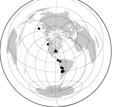
Nearby stations (2 deg radius)
| Station | Name | (Lat, Lon) | Start / End | Elevation |
| FA08 | fled station 8 | (37.32, -89.53) | 2001-06-13 / 2002-12-31 | 0.1 km |
| Crust2 Type: | D6,Platform 2 km seds. |
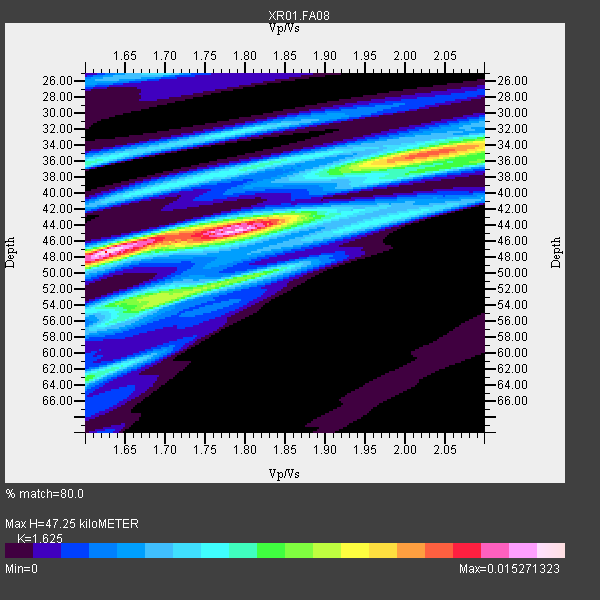
| Thickness Estimate: | 47 km |
| Thickness StdDev: | 4.8 km |
| Vp/Vs Estimate: | 1.62 |
| Vp/Vs StdDev: | 0.15 |
| Vs Estimate: | 3.965 km/s |
| Poisson's Ratio: | 0.20 |
| Peak Value: | 0.02 |
| Assumed Vp: | 6.444 km/s |
| Ps Weight: | 0.33333334 |
| PpPs Weight: | 0.33333334 |
| PsPs Weight: | 0.33333328 |
| Residual Complexity: | 0.838 |
| Nearby stations H: | +- |
| (2.0 deg) Vp/Vs: | +- |
8 with match > 90% ( 72.72727 %) and 11 with match > 80% ( 100.0 %) out of 11.
Download stack as xyz text file.
Azimuth Distribution of Events:
Prior Results for this Station
| Study | Thickness | Vp/Vs | Vp | Vs | Poissons Ratio | Extra |
| EARS | 47 km | 1.62 | 6.444 km/s | 3.965 km/s | 0.20 | |
| Crust2.0 | 41 km | 1.78 | 6.444 km/s | 3.629 km/s | 0.27 | D6,Platform 2 km seds. |
| Global Maxima | 47 km | 1.62 | 6.444 km/s | 3.965 km/s | 0.20 | amp=0.015271323 |
| Local Maxima 1 | 35 km | 2.03 | 6.444 km/s | 3.178 km/s | 0.34 | amp=0.0117672905 |
| Local Maxima 2 | 44 km | 1.79 | 6.444 km/s | 3.605 km/s | 0.27 | amp=0.0098653585 |
| Local Maxima 3 | 54 km | 1.70 | 6.444 km/s | 3.796 km/s | 0.23 | amp=0.008449089 |
| Local Maxima 4 | 50 km | 1.81 | 6.444 km/s | 3.565 km/s | 0.28 | amp=0.0067924876 |
| Predicted Arrivals for vertical incidence (zero ray parameter) | |
| Ps | 4.58 SECOND |
| PpPs | 19.25 SECOND |
| PsPs/PpSs | 23.83 SECOND |
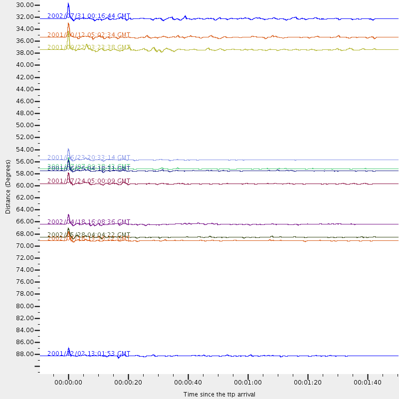
Events Processed for this Station
Download zip of receiver functions as SAC
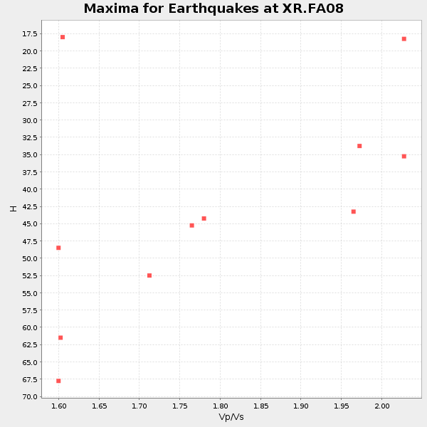
Plot maxima for each earthquake.
Events Used in the Stack
(11 events)| Radial Match | Distance | Baz | FERegion | Time | Lat/Lon | Depth | Magnitude |
| 99.232574 | 55.4 deg | 161.36 deg | Near Coast Of Peru | 2001/06/23 20:33:14 GMT | (-16.3, -73.6) | 33 km | 6.7 MB, 8.2 MS, 8.4 MW, 7.8 ME |
| 98.92189 | 57.3 deg | 159.652 deg | Near Coast Of Peru | 2001/06/26 04:18:31 GMT | (-17.7, -71.6) | 24 km | 6.2 MB, 6.7 MS, 6.8 MW, 6.7 ME |
| 98.850174 | 57.0 deg | 160.049 deg | Near Coast Of Peru | 2001/07/07 09:38:43 GMT | (-17.5, -72.1) | 33 km | 6.6 MB, 7.3 MS, 7.6 MW, 7.5 ME |
| 97.614624 | 69.9 deg | 163.187 deg | Near Coast Of Central Chile | 2002/06/18 13:56:22 GMT | (-30.8, -71.1) | 54 km | 6.0 MB, 6.6 MW, 6.4 MW |
| 97.00528 | 69.3 deg | 158.767 deg | Catamarca Province, Argentina | 2002/05/28 04:04:22 GMT | (-28.9, -66.8) | 22 km | 6.0 MB, 5.7 MS, 6.0 MW, 5.9 MW |
| 96.4423 | 59.6 deg | 157.723 deg | Northern Chile | 2001/07/24 05:00:09 GMT | (-19.4, -69.3) | 33 km | 5.7 MB, 6.2 MS, 6.3 MW, 6.3 MW |
| 95.382576 | 66.9 deg | 161.738 deg | Near Coast Of Northern Chile | 2002/04/18 16:08:36 GMT | (-27.5, -70.6) | 62 km | 6.2 MB, 6.7 MW, 6.6 MW |
| 92.32088 | 90.6 deg | 323.209 deg | Eastern Honshu, Japan | 2001/12/02 13:01:53 GMT | (39.4, 141.1) | 124 km | 6.1 MB, 6.5 MW, 6.5 MW |
| 89.999825 | 29.9 deg | 166.515 deg | South Of Panama | 2002/07/31 00:16:44 GMT | (7.9, -82.8) | 10 km | 6.0 MB, 6.4 MS, 6.5 MW, 6.4 MW |
| 89.71151 | 33.3 deg | 311.188 deg | Queen Charlotte Islands Region | 2001/10/12 05:02:34 GMT | (52.6, -132.2) | 20 km | 5.6 MB, 5.8 MS, 6.2 MW, 6.1 MW |
| 88.123215 | 35.5 deg | 156.261 deg | Colombia | 2001/09/22 03:23:38 GMT | (3.9, -76.0) | 179 km | 6.0 MB, 6.0 MW, 6.0 MW |
Losers
(0 events)| Radial Match | Distance | Baz | FERegion | Time | Lat/Lon | Depth | Magnitude | Reason |
