
Station XR FA11 - fled station 11
Network: XR01 - Florida to Edmonton Seismic Experiment
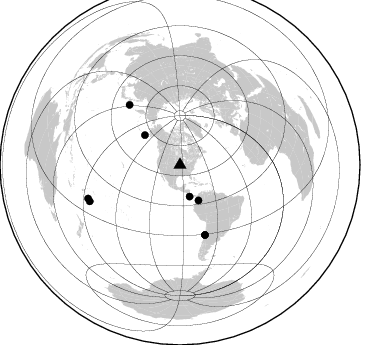
Nearby stations (2 deg radius)
| Station | Name | (Lat, Lon) | Start / End | Elevation |
| FA11 | fled station 11 | (40.82, -93.29) | 2001-05-23 / 2002-12-31 | 0.3 km |
| Crust2 Type: | D9,Platform 1 km seds. |
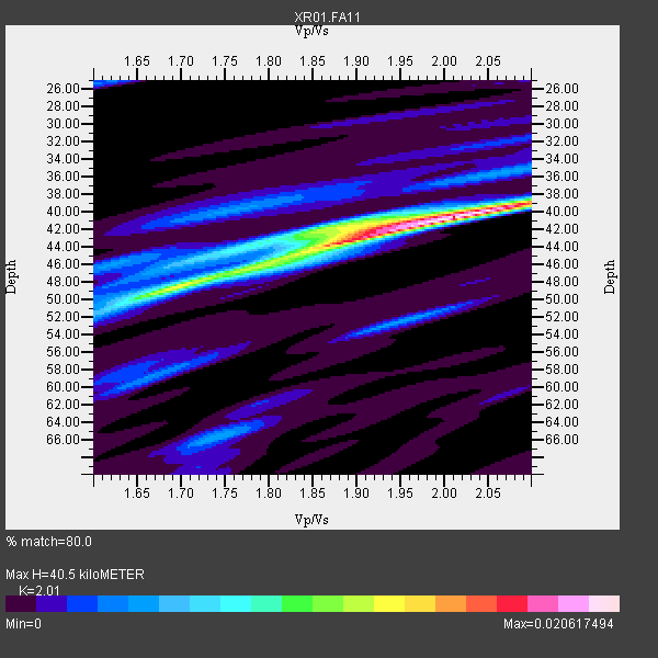
| Thickness Estimate: | 40 km |
| Thickness StdDev: | 2.4 km |
| Vp/Vs Estimate: | 2.01 |
| Vp/Vs StdDev: | 0.10 |
| Vs Estimate: | 3.233 km/s |
| Poisson's Ratio: | 0.34 |
| Peak Value: | 0.02 |
| Assumed Vp: | 6.498 km/s |
| Ps Weight: | 0.33333334 |
| PpPs Weight: | 0.33333334 |
| PsPs Weight: | 0.33333328 |
| Residual Complexity: | 0.601 |
| Nearby stations H: | +- |
| (2.0 deg) Vp/Vs: | +- |
3 with match > 90% ( 37.5 %) and 8 with match > 80% ( 100.0 %) out of 8.
Download stack as xyz text file.
Azimuth Distribution of Events:
Prior Results for this Station
| Study | Thickness | Vp/Vs | Vp | Vs | Poissons Ratio | Extra |
| EARS | 40 km | 2.01 | 6.498 km/s | 3.233 km/s | 0.34 | |
| Crust2.0 | 41 km | 1.77 | 6.498 km/s | 3.666 km/s | 0.27 | D9,Platform 1 km seds. |
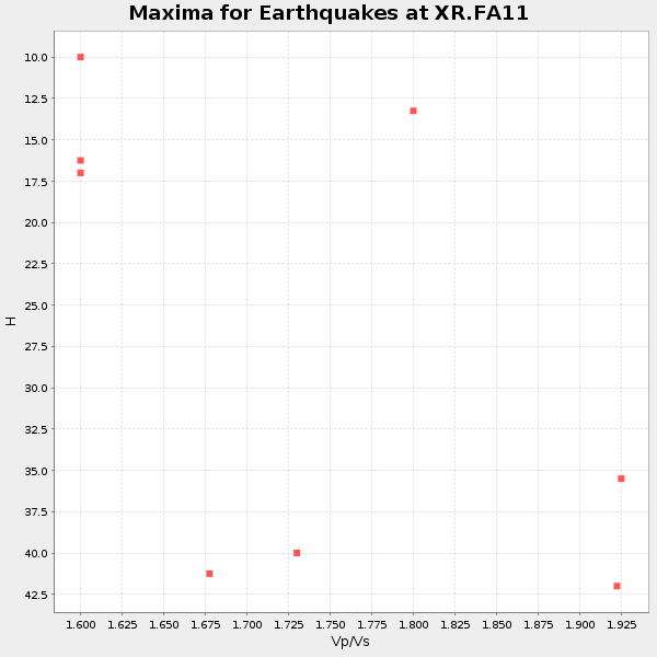
| Global Maxima | 40 km | 2.01 | 6.498 km/s | 3.233 km/s | 0.34 | amp=0.020617494 |
| Local Maxima 1 | 44 km | 1.87 | 6.498 km/s | 3.484 km/s | 0.30 | amp=0.012433972 |
| Local Maxima 2 | 48 km | 1.70 | 6.498 km/s | 3.833 km/s | 0.23 | amp=0.011563791 |
| Local Maxima 3 | 42 km | 1.88 | 6.498 km/s | 3.461 km/s | 0.30 | amp=0.006451312 |
| Local Maxima 4 | 52 km | 1.95 | 6.498 km/s | 3.341 km/s | 0.32 | amp=0.0049484475 |
| Predicted Arrivals for vertical incidence (zero ray parameter) | |
| Ps | 6.30 SECOND |
| PpPs | 18.76 SECOND |
| PsPs/PpSs | 25.06 SECOND |
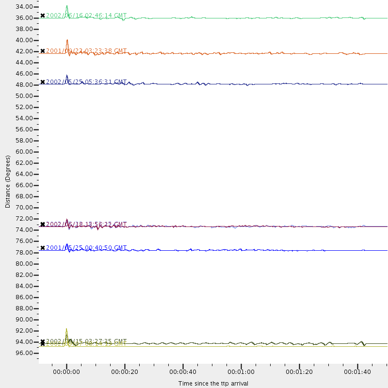
Events Processed for this Station
Download zip of receiver functions as SAC
Plot maxima for each earthquake.
Events Used in the Stack
(8 events)| Radial Match | Distance | Baz | FERegion | Time | Lat/Lon | Depth | Magnitude |
| 99.55025 | 97.7 deg | 250.02 deg | Fiji Islands Region | 2002/09/07 08:14:19 GMT | (-20.3, -176.0) | 210 km | 5.5 MB, 6.0 MW, 6.0 MW |
| 94.02744 | 46.0 deg | 310.282 deg | South Of Alaska | 2002/05/25 05:36:31 GMT | (53.8, -161.1) | 33 km | 5.5 MB, 6.1 MS, 6.5 MW, 6.4 MW |
| 91.24811 | 33.0 deg | 162.934 deg | Costa Rica | 2002/06/16 02:46:14 GMT | (8.8, -84.0) | 35 km | 5.4 MB, 6.2 MS, 6.4 MW, 6.4 MW |
| 89.74935 | 74.2 deg | 160.282 deg | Near Coast Of Central Chile | 2002/06/18 13:56:22 GMT | (-30.8, -71.1) | 54 km | 6.0 MB, 6.6 MW, 6.4 MW |
| 86.72286 | 78.8 deg | 319.855 deg | Kuril Islands | 2001/05/25 00:40:50 GMT | (44.3, 148.4) | 33 km | 6.1 MB, 6.7 MS, 6.7 MW, 6.6 MW |
| 81.87284 | 97.2 deg | 248.068 deg | Tonga Islands | 2002/05/15 03:27:35 GMT | (-21.4, -174.3) | 10 km | 5.4 MB, 5.7 MS, 5.9 MW, 5.7 MW |
| 81.4511 | 40.0 deg | 152.449 deg | Colombia | 2001/09/22 03:23:38 GMT | (3.9, -76.0) | 179 km | 6.0 MB, 6.0 MW, 6.0 MW |
| 80.42299 | 74.1 deg | 160.327 deg | Near Coast Of Central Chile | 2002/05/23 15:52:15 GMT | (-30.7, -71.2) | 52 km | 5.7 MB, 6.0 MW, 6.0 MW |
Losers
(0 events)| Radial Match | Distance | Baz | FERegion | Time | Lat/Lon | Depth | Magnitude | Reason |
