
Station XR FA12 - fled station 12
Network: XR01 - Florida to Edmonton Seismic Experiment
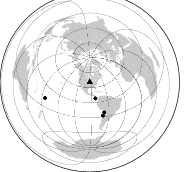
Nearby stations (2 deg radius)
| Station | Name | (Lat, Lon) | Start / End | Elevation |
| FA12 | fled station 12 | (41.14, -93.71) | 2002-03-14 / 2002-12-31 | 0.3 km |
| Crust2 Type: | D9,Platform 1 km seds. |
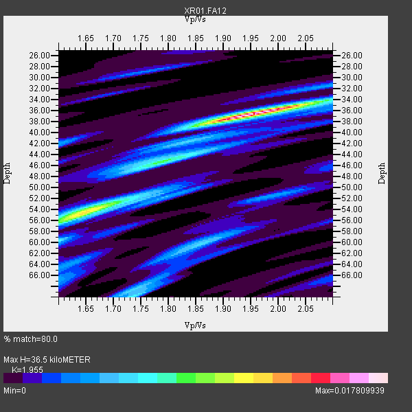
| Thickness Estimate: | 36 km |
| Thickness StdDev: | 2.8 km |
| Vp/Vs Estimate: | 1.96 |
| Vp/Vs StdDev: | 0.08 |
| Vs Estimate: | 3.324 km/s |
| Poisson's Ratio: | 0.32 |
| Peak Value: | 0.02 |
| Assumed Vp: | 6.498 km/s |
| Ps Weight: | 0.33333334 |
| PpPs Weight: | 0.33333334 |
| PsPs Weight: | 0.33333328 |
| Residual Complexity: | 0.659 |
| Nearby stations H: | +- |
| (2.0 deg) Vp/Vs: | +- |
3 with match > 90% ( 60.0 %) and 5 with match > 80% ( 100.0 %) out of 5.
Download stack as xyz text file.
Azimuth Distribution of Events:
Prior Results for this Station
| Study | Thickness | Vp/Vs | Vp | Vs | Poissons Ratio | Extra |
| EARS | 36 km | 1.96 | 6.498 km/s | 3.324 km/s | 0.32 | |
| Crust2.0 | 41 km | 1.77 | 6.498 km/s | 3.666 km/s | 0.27 | D9,Platform 1 km seds. |
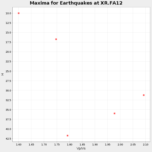
| Global Maxima | 36 km | 1.96 | 6.498 km/s | 3.324 km/s | 0.32 | amp=0.017809939 |
| Local Maxima 1 | 54 km | 1.64 | 6.498 km/s | 3.95 km/s | 0.21 | amp=0.011833915 |
| Local Maxima 2 | 70 km | 1.74 | 6.498 km/s | 3.74 km/s | 0.25 | amp=0.006909185 |
| Local Maxima 3 | 60 km | 1.87 | 6.498 km/s | 3.47 km/s | 0.30 | amp=0.004806637 |
| Local Maxima 4 | 44 km | 1.82 | 6.498 km/s | 3.57 km/s | 0.28 | amp=0.0041126725 |
| Predicted Arrivals for vertical incidence (zero ray parameter) | |
| Ps | 5.36 SECOND |
| PpPs | 16.60 SECOND |
| PsPs/PpSs | 21.96 SECOND |
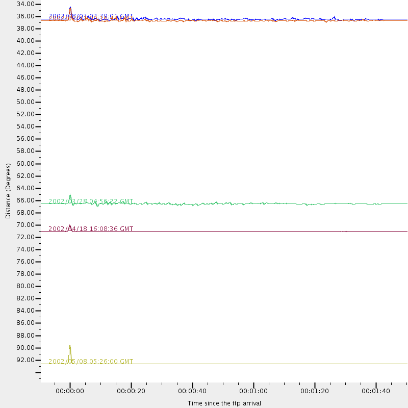
Events Processed for this Station
Download zip of receiver functions as SAC
Plot maxima for each earthquake.
Events Used in the Stack
(5 events)| Radial Match | Distance | Baz | FERegion | Time | Lat/Lon | Depth | Magnitude |
| 99.92163 | 95.0 deg | 250.63 deg | Tonga Islands | 2002/05/08 05:26:00 GMT | (-17.9, -174.6) | 131 km | 5.4 MB, 6.3 MW, 6.2 MW |
| 94.91695 | 71.6 deg | 158.438 deg | Near Coast Of Northern Chile | 2002/04/18 16:08:36 GMT | (-27.5, -70.6) | 62 km | 6.2 MB, 6.7 MW, 6.6 MW |
| 93.160675 | 34.5 deg | 160.639 deg | South Of Panama | 2002/07/31 00:16:44 GMT | (7.9, -82.8) | 10 km | 6.0 MB, 6.4 MS, 6.5 MW, 6.4 MW |
| 87.80714 | 34.1 deg | 160.539 deg | Panama-Costa Rica Border Region | 2002/08/03 02:39:01 GMT | (8.3, -82.8) | 10 km | 5.4 MB, 5.5 MS, 5.9 MW, 5.7 MW |
| 85.22046 | 66.8 deg | 154.286 deg | Chile-Bolivia Border Region | 2002/03/28 04:56:22 GMT | (-21.7, -68.3) | 125 km | 6.1 MB, 6.5 MW, 6.5 MW |
Losers
(0 events)| Radial Match | Distance | Baz | FERegion | Time | Lat/Lon | Depth | Magnitude | Reason |
