
Station XR FA15 - fled station 15
Network: XR01 - Florida to Edmonton Seismic Experiment
Nearby stations (2 deg radius)
| Station | Name | (Lat, Lon) | Start / End | Elevation |
| FA15 | fled station 15 | (41.77, -94.47) | 2001-05-23 / 2002-12-31 | 0.3 km |
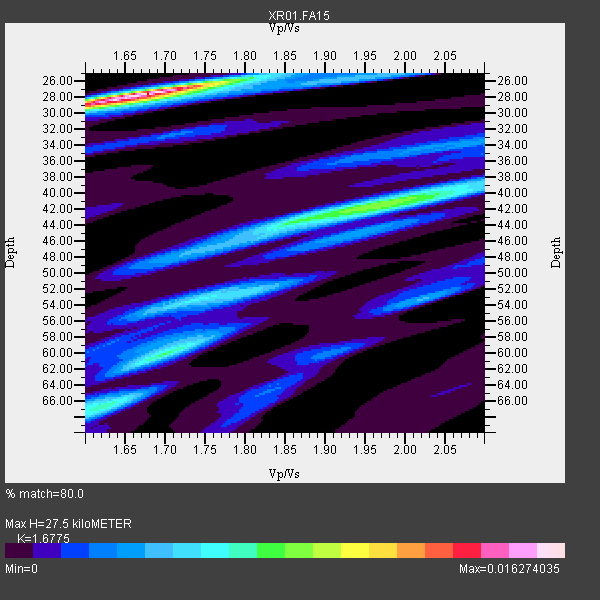
| Crust2 Type: | D9,Platform 1 km seds. |
| Thickness Estimate: | 28 km |
| Thickness StdDev: | 10 km |
| Vp/Vs Estimate: | 1.68 |
| Vp/Vs StdDev: | 0.07 |
| Vs Estimate: | 3.873 km/s |
| Poisson's Ratio: | 0.22 |
| Peak Value: | 0.02 |
| Assumed Vp: | 6.498 km/s |
| Ps Weight: | 0.33333334 |
| PpPs Weight: | 0.33333334 |
| PsPs Weight: | 0.33333328 |
| Residual Complexity: | 0.756 |
| Nearby stations H: | +- |
| (2.0 deg) Vp/Vs: | +- |
10 with match > 90% ( 55.555557 %) and 18 with match > 80% ( 100.0 %) out of 18.
Download stack as xyz text file.
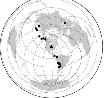
Azimuth Distribution of Events:
Prior Results for this Station
| Study | Thickness | Vp/Vs | Vp | Vs | Poissons Ratio | Extra |
| EARS | 28 km | 1.68 | 6.498 km/s | 3.873 km/s | 0.22 | |
| Crust2.0 | 41 km | 1.77 | 6.498 km/s | 3.666 km/s | 0.27 | D9,Platform 1 km seds. |
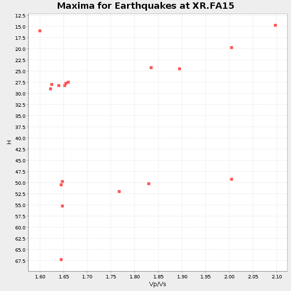
| Global Maxima | 28 km | 1.68 | 6.498 km/s | 3.873 km/s | 0.22 | amp=0.016274035 |
| Local Maxima 1 | 41 km | 1.98 | 6.498 km/s | 3.282 km/s | 0.33 | amp=0.008622469 |
| Local Maxima 2 | 60 km | 1.70 | 6.498 km/s | 3.822 km/s | 0.24 | amp=0.0073464983 |
| Local Maxima 3 | 44 km | 1.85 | 6.498 km/s | 3.512 km/s | 0.29 | amp=0.0054785814 |
| Local Maxima 4 | 66 km | 1.62 | 6.498 km/s | 4.005 km/s | 0.19 | amp=0.005299213 |
| Predicted Arrivals for vertical incidence (zero ray parameter) | |
| Ps | 2.87 SECOND |
| PpPs | 11.33 SECOND |
| PsPs/PpSs | 14.20 SECOND |
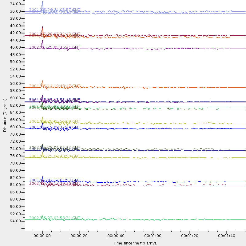
Events Processed for this Station
Download zip of receiver functions as SAC
Plot maxima for each earthquake.
Events Used in the Stack
(18 events)| Radial Match | Distance | Baz | FERegion | Time | Lat/Lon | Depth | Magnitude |
| 98.89583 | 85.7 deg | 329.001 deg | E. Russia-N.E. China Border Reg. | 2002/06/28 17:19:30 GMT | (43.8, 130.7) | 566 km | 6.7 MB, 7.3 MW, 7.3 MW |
| 98.566666 | 60.9 deg | 156.99 deg | Near Coast Of Peru | 2001/06/23 20:33:14 GMT | (-16.3, -73.6) | 33 km | 6.7 MB, 8.2 MS, 8.4 MW, 7.8 ME |
| 98.28633 | 62.9 deg | 155.465 deg | Near Coast Of Peru | 2001/06/26 04:18:31 GMT | (-17.7, -71.6) | 24 km | 6.2 MB, 6.7 MS, 6.8 MW, 6.7 ME |
| 98.01821 | 62.5 deg | 155.826 deg | Near Coast Of Peru | 2001/07/07 09:38:43 GMT | (-17.5, -72.1) | 33 km | 6.6 MB, 7.3 MS, 7.6 MW, 7.5 ME |
| 93.83178 | 74.9 deg | 155.061 deg | Catamarca Province, Argentina | 2002/05/28 04:04:22 GMT | (-28.9, -66.8) | 22 km | 6.0 MB, 5.7 MS, 6.0 MW, 5.9 MW |
| 93.06472 | 34.1 deg | 161.325 deg | Costa Rica | 2002/06/16 02:46:14 GMT | (8.8, -84.0) | 35 km | 5.4 MB, 6.2 MS, 6.4 MW, 6.4 MW |
| 92.7492 | 75.4 deg | 159.369 deg | Near Coast Of Central Chile | 2002/06/18 13:56:22 GMT | (-30.8, -71.1) | 54 km | 6.0 MB, 6.6 MW, 6.4 MW |
| 92.74405 | 40.7 deg | 316.312 deg | Southern Alaska | 2001/07/28 07:32:43 GMT | (59.0, -155.1) | 131 km | 5.7 MB, 5.7 MS, 6.6 MW, 6.2 ME |
| 92.56292 | 44.7 deg | 309.347 deg | South Of Alaska | 2002/05/25 05:36:31 GMT | (53.8, -161.1) | 33 km | 5.5 MB, 6.1 MS, 6.5 MW, 6.4 MW |
| 91.31695 | 77.5 deg | 319.092 deg | Kuril Islands | 2001/05/25 00:40:50 GMT | (44.3, 148.4) | 33 km | 6.1 MB, 6.7 MS, 6.7 MW, 6.6 MW |
| 89.99541 | 56.4 deg | 311.089 deg | Andreanof Islands, Aleutian Is. | 2001/06/14 19:48:47 GMT | (51.2, -179.8) | 18 km | 6.0 MB, 6.3 MS, 6.5 MW, 6.1 ML |
| 87.62131 | 60.6 deg | 157.292 deg | Near Coast Of Peru | 2001/07/05 13:53:48 GMT | (-16.1, -74.0) | 62 km | 6.2 MB, 6.6 MW, 6.5 ME |
| 86.37459 | 67.1 deg | 155.395 deg | Near Coast Of Northern Chile | 2001/08/28 06:56:09 GMT | (-21.7, -70.1) | 66 km | 5.8 MB, 5.9 MW, 5.8 MW |
| 86.09705 | 68.7 deg | 153.682 deg | Chile-Bolivia Border Region | 2001/06/19 09:32:24 GMT | (-22.7, -67.9) | 147 km | 5.5 MB, 5.2 MS, 6.1 MW, 5.9 MW |
| 84.83793 | 33.5 deg | 321.4 deg | Southern Yukon Territory, Canada | 2001/06/26 14:05:37 GMT | (61.3, -140.1) | 10 km | 5.8 MB, 5.4 MS, 6.0 ML, 5.8 MW |
| 84.138016 | 41.2 deg | 151.283 deg | Colombia | 2001/09/22 03:23:38 GMT | (3.9, -76.0) | 179 km | 6.0 MB, 6.0 MW, 6.0 MW |
| 82.794716 | 84.7 deg | 320.085 deg | Eastern Honshu, Japan | 2001/12/02 13:01:53 GMT | (39.4, 141.1) | 124 km | 6.1 MB, 6.5 MW, 6.5 MW |
| 81.08959 | 96.0 deg | 29.153 deg | Western Iran | 2002/06/22 02:58:21 GMT | (35.6, 49.0) | 10 km | 6.2 MB, 6.4 MS, 6.5 MW, 6.5 MW |
Losers
(0 events)| Radial Match | Distance | Baz | FERegion | Time | Lat/Lon | Depth | Magnitude | Reason |
