
Station XR FA16 - fled station 16
Network: XR01 - Florida to Edmonton Seismic Experiment
Nearby stations (2 deg radius)
| Station | Name | (Lat, Lon) | Start / End | Elevation |
| FA16 | fled station 16 | (41.89, -94.60) | 2001-05-25 / 2002-12-31 | 0.3 km |
| Crust2 Type: | D9,Platform 1 km seds. |
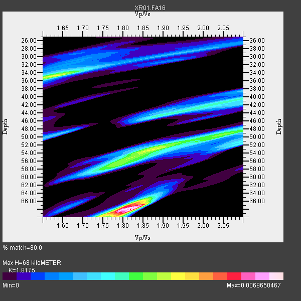
| Thickness Estimate: | 68 km |
| Thickness StdDev: | 14 km |
| Vp/Vs Estimate: | 1.82 |
| Vp/Vs StdDev: | 0.13 |
| Vs Estimate: | 3.575 km/s |
| Poisson's Ratio: | 0.28 |
| Peak Value: | 0.01 |
| Assumed Vp: | 6.498 km/s |
| Ps Weight: | 0.33333334 |
| PpPs Weight: | 0.33333334 |
| PsPs Weight: | 0.33333328 |
| Residual Complexity: | 0.861 |
| Nearby stations H: | +- |
| (2.0 deg) Vp/Vs: | +- |
9 with match > 90% ( 64.28571 %) and 14 with match > 80% ( 100.0 %) out of 14.
Download stack as xyz text file.
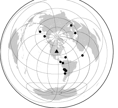
Azimuth Distribution of Events:
Prior Results for this Station
| Study | Thickness | Vp/Vs | Vp | Vs | Poissons Ratio | Extra |
| EARS | 68 km | 1.82 | 6.498 km/s | 3.575 km/s | 0.28 | |
| Crust2.0 | 41 km | 1.77 | 6.498 km/s | 3.666 km/s | 0.27 | D9,Platform 1 km seds. |
| Global Maxima | 68 km | 1.82 | 6.498 km/s | 3.575 km/s | 0.28 | amp=0.0069650467 |
| Local Maxima 1 | 34 km | 1.64 | 6.498 km/s | 3.962 km/s | 0.20 | amp=0.0044938754 |
| Local Maxima 2 | 53 km | 1.86 | 6.498 km/s | 3.489 km/s | 0.30 | amp=0.0043024593 |
| Local Maxima 3 | 67 km | 1.81 | 6.498 km/s | 3.6 km/s | 0.28 | amp=0.0034404828 |
| Local Maxima 4 | 57 km | 1.76 | 6.498 km/s | 3.681 km/s | 0.26 | amp=0.003203453 |
| Predicted Arrivals for vertical incidence (zero ray parameter) | |
| Ps | 8.56 SECOND |
| PpPs | 29.49 SECOND |
| PsPs/PpSs | 38.04 SECOND |
Events Processed for this Station
Download zip of receiver functions as SAC
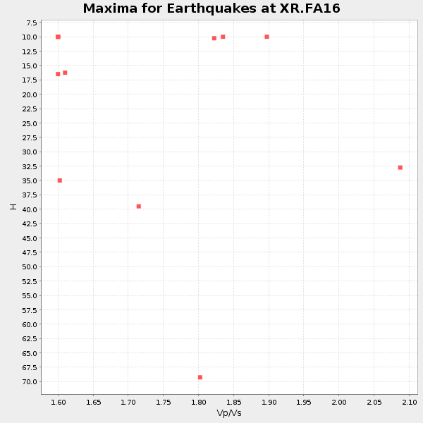
Plot maxima for each earthquake.
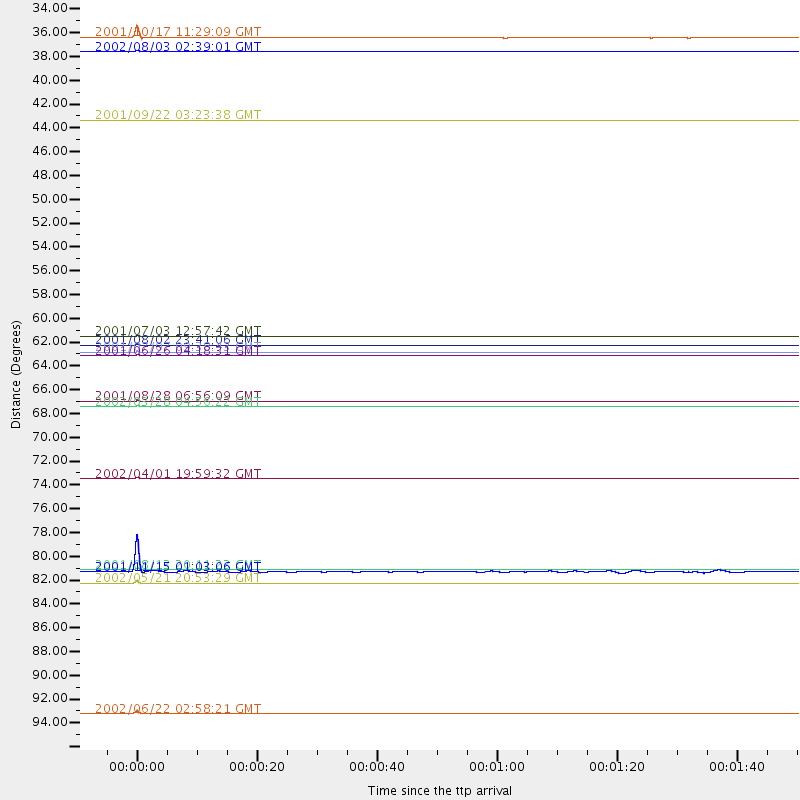
Events Used in the Stack
(14 events)| Radial Match | Distance | Baz | FERegion | Time | Lat/Lon | Depth | Magnitude |
| 99.984985 | 82.7 deg | 320.296 deg | Hokkaido, Japan Region | 2001/08/13 20:11:23 GMT | (41.0, 142.3) | 38 km | 6.0 MB, 6.3 MS, 6.4 MW, 6.3 ME |
| 99.98259 | 62.1 deg | 321.788 deg | Near East Coast Of Kamchatka | 2001/08/02 23:41:06 GMT | (56.3, 163.8) | 14 km | 5.9 MB, 6.2 MS, 6.3 MW, 6.2 ME |
| 99.851715 | 84.0 deg | 45.103 deg | Southern Greece | 2002/05/21 20:53:29 GMT | (36.6, 24.3) | 97 km | 5.4 MB, 5.6 MD |
| 99.469696 | 41.4 deg | 151.162 deg | Colombia | 2001/09/22 03:23:38 GMT | (3.9, -76.0) | 179 km | 6.0 MB, 6.0 MW, 6.0 MW |
| 98.29806 | 63.0 deg | 155.356 deg | Near Coast Of Peru | 2001/06/26 04:18:31 GMT | (-17.7, -71.6) | 24 km | 6.2 MB, 6.7 MS, 6.8 MW, 6.7 ME |
| 98.29212 | 96.0 deg | 29.05 deg | Western Iran | 2002/06/22 02:58:21 GMT | (35.6, 49.0) | 10 km | 6.2 MB, 6.4 MS, 6.5 MW, 6.5 MW |
| 97.96781 | 62.7 deg | 155.716 deg | Near Coast Of Peru | 2001/07/07 09:38:43 GMT | (-17.5, -72.1) | 33 km | 6.6 MB, 7.3 MS, 7.6 MW, 7.5 ME |
| 93.75128 | 67.8 deg | 153.588 deg | Chile-Bolivia Border Region | 2002/03/28 04:56:22 GMT | (-21.7, -68.3) | 125 km | 6.1 MB, 6.5 MW, 6.5 MW |
| 93.57504 | 82.9 deg | 98.53 deg | North Of Ascension Island | 2001/11/15 01:03:06 GMT | (-1.6, -15.6) | 10 km | 5.5 MB, 6.0 MS, 6.3 MW, 6.3 MW |
| 86.84219 | 35.1 deg | 159.419 deg | Panama-Costa Rica Border Region | 2002/08/03 02:39:01 GMT | (8.3, -82.8) | 10 km | 5.4 MB, 5.5 MS, 5.9 MW, 5.7 MW |
| 86.628 | 33.7 deg | 122.684 deg | Virgin Islands | 2001/10/17 11:29:09 GMT | (19.4, -64.9) | 33 km | 5.3 MB, 5.6 MS, 6.0 MW, 5.8 MW |
| 83.67187 | 67.2 deg | 155.29 deg | Near Coast Of Northern Chile | 2001/08/28 06:56:09 GMT | (-21.7, -70.1) | 66 km | 5.8 MB, 5.9 MW, 5.8 MW |
| 82.41059 | 74.4 deg | 159.13 deg | Near Coast Of Central Chile | 2002/04/01 19:59:32 GMT | (-29.7, -71.4) | 71 km | 6.1 MB, 6.4 MW, 6.4 MW |
| 81.22266 | 61.3 deg | 157.344 deg | Near Coast Of Peru | 2001/07/03 12:57:42 GMT | (-16.6, -74.0) | 33 km | 5.4 MB, 5.1 MS, 5.8 MW, 5.6 MW |
Losers
(0 events)| Radial Match | Distance | Baz | FERegion | Time | Lat/Lon | Depth | Magnitude | Reason |
