
Station XR FA20 - fled station 20
Network: XR01 - Florida to Edmonton Seismic Experiment
Nearby stations (2 deg radius)
| Station | Name | (Lat, Lon) | Start / End | Elevation |
| FA20 | fled station 20 | (42.97, -95.98) | 2001-06-02 / 2002-12-31 | 0.4 km |
| Crust2 Type: | DE,thick Platform 1 km seds. |
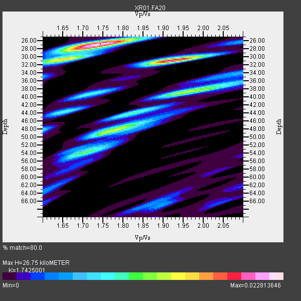
| Thickness Estimate: | 27 km |
| Thickness StdDev: | 8.3 km |
| Vp/Vs Estimate: | 1.74 |
| Vp/Vs StdDev: | 0.11 |
| Vs Estimate: | 3.748 km/s |
| Poisson's Ratio: | 0.25 |
| Peak Value: | 0.02 |
| Assumed Vp: | 6.53 km/s |
| Ps Weight: | 0.33333334 |
| PpPs Weight: | 0.33333334 |
| PsPs Weight: | 0.33333328 |
| Residual Complexity: | 0.765 |
| Nearby stations H: | +- |
| (2.0 deg) Vp/Vs: | +- |
9 with match > 90% ( 50.0 %) and 18 with match > 80% ( 100.0 %) out of 18.
Download stack as xyz text file.
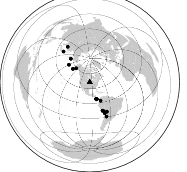
Azimuth Distribution of Events:
Prior Results for this Station
| Study | Thickness | Vp/Vs | Vp | Vs | Poissons Ratio | Extra |
| EARS | 27 km | 1.74 | 6.53 km/s | 3.748 km/s | 0.25 | |
| Crust2.0 | 46 km | 1.77 | 6.53 km/s | 3.68 km/s | 0.27 | DE,thick Platform 1 km seds. |
| Global Maxima | 27 km | 1.74 | 6.53 km/s | 3.748 km/s | 0.25 | amp=0.022813646 |
| Local Maxima 1 | 31 km | 1.92 | 6.53 km/s | 3.392 km/s | 0.32 | amp=0.020366995 |
| Local Maxima 2 | 39 km | 1.95 | 6.53 km/s | 3.349 km/s | 0.32 | amp=0.01580092 |
| Local Maxima 3 | 31 km | 1.64 | 6.53 km/s | 3.982 km/s | 0.20 | amp=0.011521811 |
| Local Maxima 4 | 54 km | 1.71 | 6.53 km/s | 3.813 km/s | 0.24 | amp=0.01142664 |
| Predicted Arrivals for vertical incidence (zero ray parameter) | |
| Ps | 3.04 SECOND |
| PpPs | 11.23 SECOND |
| PsPs/PpSs | 14.28 SECOND |
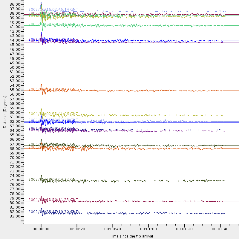
Events Processed for this Station
Download zip of receiver functions as SAC
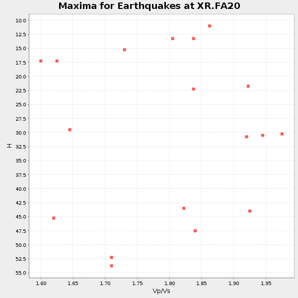
Plot maxima for each earthquake.
Events Used in the Stack
(18 events)| Radial Match | Distance | Baz | FERegion | Time | Lat/Lon | Depth | Magnitude |
| 96.35441 | 84.1 deg | 328.015 deg | E. Russia-N.E. China Border Reg. | 2002/06/28 17:19:30 GMT | (43.8, 130.7) | 566 km | 6.7 MB, 7.3 MW, 7.3 MW |
| 95.96199 | 43.1 deg | 308.09 deg | South Of Alaska | 2002/05/25 05:36:31 GMT | (53.8, -161.1) | 33 km | 5.5 MB, 6.1 MS, 6.5 MW, 6.4 MW |
| 95.87379 | 64.1 deg | 154.553 deg | Near Coast Of Peru | 2001/07/07 09:38:43 GMT | (-17.5, -72.1) | 33 km | 6.6 MB, 7.3 MS, 7.6 MW, 7.5 ME |
| 95.53943 | 62.4 deg | 155.681 deg | Near Coast Of Peru | 2001/06/23 20:33:14 GMT | (-16.3, -73.6) | 33 km | 6.7 MB, 8.2 MS, 8.4 MW, 7.8 ME |
| 94.59494 | 35.6 deg | 159.375 deg | Costa Rica | 2002/06/16 02:46:14 GMT | (8.8, -84.0) | 35 km | 5.4 MB, 6.2 MS, 6.4 MW, 6.4 MW |
| 93.84434 | 62.1 deg | 155.975 deg | Near Coast Of Peru | 2001/07/05 13:53:48 GMT | (-16.1, -74.0) | 62 km | 6.2 MB, 6.6 MW, 6.5 ME |
| 93.78483 | 60.6 deg | 320.93 deg | Near East Coast Of Kamchatka | 2001/08/02 23:41:06 GMT | (56.3, 163.8) | 14 km | 5.9 MB, 6.2 MS, 6.3 MW, 6.2 ME |
| 93.107086 | 64.4 deg | 154.2 deg | Near Coast Of Peru | 2001/06/26 04:18:31 GMT | (-17.7, -71.6) | 24 km | 6.2 MB, 6.7 MS, 6.8 MW, 6.7 ME |
| 91.08785 | 81.2 deg | 319.381 deg | Hokkaido, Japan Region | 2001/08/13 20:11:23 GMT | (41.0, 142.3) | 38 km | 6.0 MB, 6.3 MS, 6.4 MW, 6.3 ME |
| 89.63047 | 76.4 deg | 153.919 deg | Catamarca Province, Argentina | 2002/05/28 04:04:22 GMT | (-28.9, -66.8) | 22 km | 6.0 MB, 5.7 MS, 6.0 MW, 5.9 MW |
| 87.90484 | 39.1 deg | 315.259 deg | Southern Alaska | 2001/07/28 07:32:43 GMT | (59.0, -155.1) | 131 km | 5.7 MB, 5.7 MS, 6.6 MW, 6.2 ME |
| 86.70027 | 36.8 deg | 157.83 deg | South Of Panama | 2002/07/31 00:16:44 GMT | (7.9, -82.8) | 10 km | 6.0 MB, 6.4 MS, 6.5 MW, 6.4 MW |
| 86.17043 | 42.8 deg | 149.839 deg | Colombia | 2001/09/22 03:23:38 GMT | (3.9, -76.0) | 179 km | 6.0 MB, 6.0 MW, 6.0 MW |
| 85.93377 | 67.9 deg | 149.695 deg | Southern Bolivia | 2001/06/29 18:35:51 GMT | (-19.5, -66.3) | 274 km | 5.7 MB, 6.1 MW, 6.1 MW |
| 85.42002 | 54.8 deg | 309.949 deg | Andreanof Islands, Aleutian Is. | 2001/06/14 19:48:47 GMT | (51.2, -179.8) | 18 km | 6.0 MB, 6.3 MS, 6.5 MW, 6.1 ML |
| 84.33898 | 36.4 deg | 157.72 deg | Panama-Costa Rica Border Region | 2002/08/03 02:39:01 GMT | (8.3, -82.8) | 10 km | 5.4 MB, 5.5 MS, 5.9 MW, 5.7 MW |
| 83.00427 | 68.6 deg | 154.176 deg | Near Coast Of Northern Chile | 2001/08/28 06:56:09 GMT | (-21.7, -70.1) | 66 km | 5.8 MB, 5.9 MW, 5.8 MW |
| 81.64085 | 37.1 deg | 157.924 deg | South Of Panama | 2001/08/25 02:02:02 GMT | (7.6, -82.8) | 24 km | 5.9 MB, 5.7 MS, 6.2 MW, 6.1 MW |
Losers
(0 events)| Radial Match | Distance | Baz | FERegion | Time | Lat/Lon | Depth | Magnitude | Reason |
