
Station XR FA23 - fled station 23
Network: XR01 - Florida to Edmonton Seismic Experiment
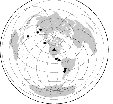
Nearby stations (2 deg radius)
| Station | Name | (Lat, Lon) | Start / End | Elevation |
| FA23 | fled station 23 | (45.55, -99.98) | 2001-06-07 / 2002-12-31 | 0.5 km |
| Crust2 Type: | DE,thick Platform 1 km seds. |
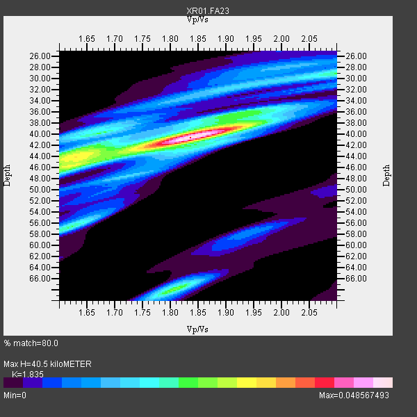
| Thickness Estimate: | 40 km |
| Thickness StdDev: | 3.8 km |
| Vp/Vs Estimate: | 1.84 |
| Vp/Vs StdDev: | 0.09 |
| Vs Estimate: | 3.559 km/s |
| Poisson's Ratio: | 0.29 |
| Peak Value: | 0.05 |
| Assumed Vp: | 6.53 km/s |
| Ps Weight: | 0.33333334 |
| PpPs Weight: | 0.33333334 |
| PsPs Weight: | 0.33333328 |
| Residual Complexity: | 0.656 |
| Nearby stations H: | +- |
| (2.0 deg) Vp/Vs: | +- |
7 with match > 90% ( 63.636364 %) and 11 with match > 80% ( 100.0 %) out of 11.
Download stack as xyz text file.
Azimuth Distribution of Events:
Prior Results for this Station
| Study | Thickness | Vp/Vs | Vp | Vs | Poissons Ratio | Extra |
| EARS | 40 km | 1.84 | 6.53 km/s | 3.559 km/s | 0.29 | |
| Crust2.0 | 46 km | 1.77 | 6.53 km/s | 3.68 km/s | 0.27 | DE,thick Platform 1 km seds. |
| Global Maxima | 40 km | 1.84 | 6.53 km/s | 3.559 km/s | 0.29 | amp=0.048567493 |
| Local Maxima 1 | 46 km | 1.62 | 6.53 km/s | 4.025 km/s | 0.19 | amp=0.029100161 |
| Local Maxima 2 | 68 km | 1.81 | 6.53 km/s | 3.613 km/s | 0.28 | amp=0.025059536 |
| Local Maxima 3 | 56 km | 1.62 | 6.53 km/s | 4.025 km/s | 0.19 | amp=0.022555957 |
| Local Maxima 4 | 29 km | 2.10 | 6.53 km/s | 3.113 km/s | 0.35 | amp=0.021087557 |
| Predicted Arrivals for vertical incidence (zero ray parameter) | |
| Ps | 5.18 SECOND |
| PpPs | 17.58 SECOND |
| PsPs/PpSs | 22.76 SECOND |
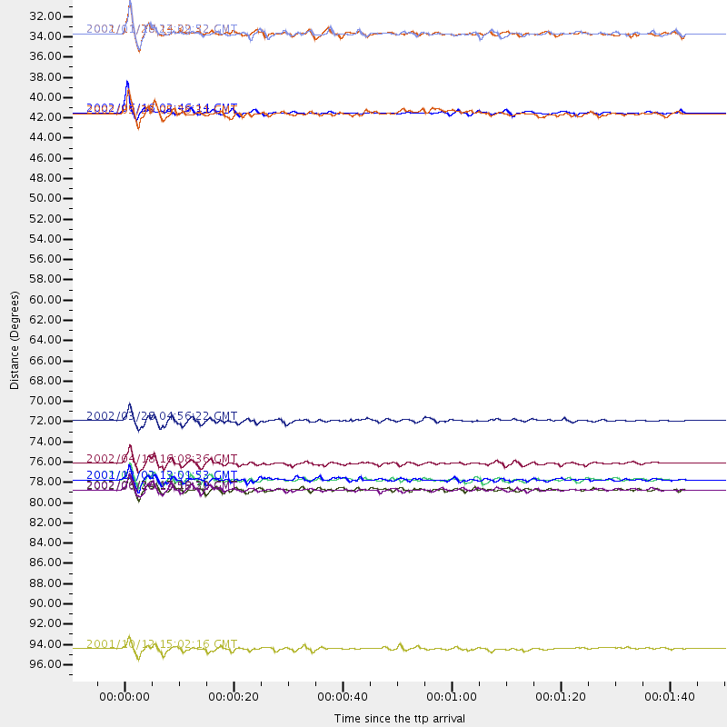
Events Processed for this Station
Download zip of receiver functions as SAC
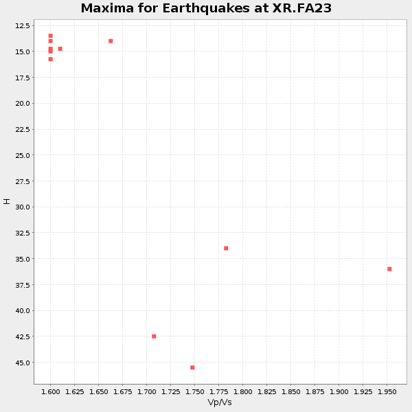
Plot maxima for each earthquake.
Events Used in the Stack
(11 events)| Radial Match | Distance | Baz | FERegion | Time | Lat/Lon | Depth | Magnitude |
| 96.82634 | 80.4 deg | 325.362 deg | E. Russia-N.E. China Border Reg. | 2002/06/28 17:19:30 GMT | (43.8, 130.7) | 566 km | 6.7 MB, 7.3 MW, 7.3 MW |
| 96.455734 | 80.4 deg | 155.089 deg | Near Coast Of Central Chile | 2002/06/18 13:56:22 GMT | (-30.8, -71.1) | 54 km | 6.0 MB, 6.6 MW, 6.4 MW |
| 96.33107 | 72.8 deg | 149.272 deg | Chile-Bolivia Border Region | 2002/03/28 04:56:22 GMT | (-21.7, -68.3) | 125 km | 6.1 MB, 6.5 MW, 6.5 MW |
| 95.24619 | 97.8 deg | 296.827 deg | South Of Mariana Islands | 2001/10/12 15:02:16 GMT | (12.7, 145.0) | 37 km | 6.7 MB, 7.3 MS, 7.0 MW, 6.9 MW |
| 95.22385 | 79.3 deg | 316.351 deg | Eastern Honshu, Japan | 2001/12/02 13:01:53 GMT | (39.4, 141.1) | 124 km | 6.1 MB, 6.5 MW, 6.5 MW |
| 94.45829 | 77.5 deg | 153.482 deg | Near Coast Of Northern Chile | 2002/04/18 16:08:36 GMT | (-27.5, -70.6) | 62 km | 6.2 MB, 6.7 MW, 6.6 MW |
| 91.53712 | 39.1 deg | 154.443 deg | Costa Rica | 2002/06/16 02:46:14 GMT | (8.8, -84.0) | 35 km | 5.4 MB, 6.2 MS, 6.4 MW, 6.4 MW |
| 89.91418 | 30.4 deg | 166.832 deg | Near Coast Of Chiapas, Mexico | 2001/11/28 14:32:32 GMT | (15.6, -93.1) | 85 km | 5.7 MB, 6.4 MW, 6.4 MW |
| 89.27662 | 30.5 deg | 166.906 deg | Near Coast Of Chiapas, Mexico | 2002/01/16 23:09:52 GMT | (15.5, -93.1) | 80 km | 5.8 MB, 6.4 MW, 6.4 MW |
| 87.63119 | 39.3 deg | 304.889 deg | South Of Alaska | 2002/05/25 05:36:31 GMT | (53.8, -161.1) | 33 km | 5.5 MB, 6.1 MS, 6.5 MW, 6.4 MW |
| 86.41448 | 79.3 deg | 154.909 deg | Near Coast Of Central Chile | 2002/04/01 19:59:32 GMT | (-29.7, -71.4) | 71 km | 6.1 MB, 6.4 MW, 6.4 MW |
Losers
(0 events)| Radial Match | Distance | Baz | FERegion | Time | Lat/Lon | Depth | Magnitude | Reason |
