
Station XR FA24 - fled station 24
Network: XR01 - Florida to Edmonton Seismic Experiment
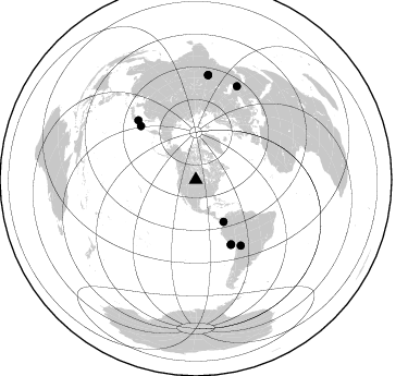
Nearby stations (2 deg radius)
| Station | Name | (Lat, Lon) | Start / End | Elevation |
| FA24 | fled station 24 | (46.53, -101.24) | 2001-06-02 / 2002-12-31 | 0.6 km |
| Crust2 Type: | H5,early/mid Proter. shield, Africa, 3 km seds. |
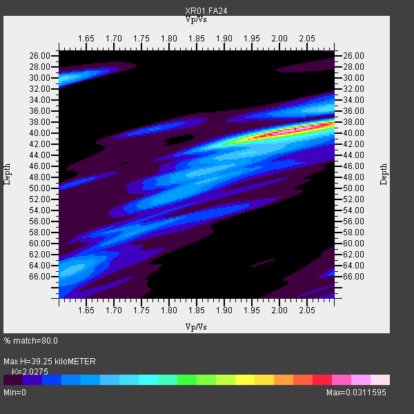
| Thickness Estimate: | 39 km |
| Thickness StdDev: | 1.2 km |
| Vp/Vs Estimate: | 2.03 |
| Vp/Vs StdDev: | 0.02 |
| Vs Estimate: | 3.175 km/s |
| Poisson's Ratio: | 0.34 |
| Peak Value: | 0.03 |
| Assumed Vp: | 6.438 km/s |
| Ps Weight: | 0.33333334 |
| PpPs Weight: | 0.33333334 |
| PsPs Weight: | 0.33333328 |
| Residual Complexity: | 0.488 |
| Nearby stations H: | +- |
| (2.0 deg) Vp/Vs: | +- |
7 with match > 90% ( 77.77778 %) and 9 with match > 80% ( 100.0 %) out of 9.
Download stack as xyz text file.
Azimuth Distribution of Events:
Prior Results for this Station
| Study | Thickness | Vp/Vs | Vp | Vs | Poissons Ratio | Extra |
| EARS | 39 km | 2.03 | 6.438 km/s | 3.175 km/s | 0.34 | |
| Crust2.0 | 48 km | 1.78 | 6.438 km/s | 3.613 km/s | 0.27 | H5,early/mid Proter. shield, Africa, 3 km seds. |
| Global Maxima | 39 km | 2.03 | 6.438 km/s | 3.175 km/s | 0.34 | amp=0.0311595 |
| Local Maxima 1 | 30 km | 1.60 | 6.438 km/s | 4.023 km/s | 0.18 | amp=0.010378337 |
| Local Maxima 2 | 40 km | 2.09 | 6.438 km/s | 3.088 km/s | 0.35 | amp=0.006844512 |
| Local Maxima 3 | 52 km | 1.81 | 6.438 km/s | 3.566 km/s | 0.28 | amp=0.00627572 |
| Local Maxima 4 | 36 km | 2.05 | 6.438 km/s | 3.136 km/s | 0.34 | amp=0.005574201 |
| Predicted Arrivals for vertical incidence (zero ray parameter) | |
| Ps | 6.26 SECOND |
| PpPs | 18.46 SECOND |
| PsPs/PpSs | 24.72 SECOND |
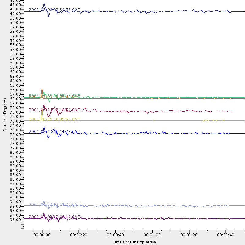
Events Processed for this Station
Download zip of receiver functions as SAC
Plot maxima for each earthquake.
Events Used in the Stack
(9 events)| Radial Match | Distance | Baz | FERegion | Time | Lat/Lon | Depth | Magnitude |
| 99.33333 | 67.5 deg | 151.612 deg | Near Coast Of Peru | 2001/07/03 12:57:42 GMT | (-16.6, -74.0) | 33 km | 5.4 MB, 5.1 MS, 5.8 MW, 5.6 MW |
| 99.11842 | 73.0 deg | 145.551 deg | Southern Bolivia | 2001/06/29 18:35:51 GMT | (-19.5, -66.3) | 274 km | 5.7 MB, 6.1 MW, 6.1 MW |
| 97.74112 | 67.3 deg | 151.157 deg | Near Coast Of Peru | 2001/06/23 20:33:14 GMT | (-16.3, -73.6) | 33 km | 6.7 MB, 8.2 MS, 8.4 MW, 7.8 ME |
| 93.9212 | 97.1 deg | 6.755 deg | Hindu Kush Region, Afghanistan | 2002/03/03 12:08:07 GMT | (36.4, 70.4) | 209 km | 6.3 MB |
| 92.84984 | 97.0 deg | 6.712 deg | Hindu Kush Region, Afghanistan | 2002/03/03 12:08:19 GMT | (36.5, 70.5) | 226 km | 6.6 MB, 7.4 MW, 7.3 MW |
| 92.031364 | 94.0 deg | 23.876 deg | Western Iran | 2002/06/22 02:58:21 GMT | (35.6, 49.0) | 10 km | 6.2 MB, 6.4 MS, 6.5 MW, 6.5 MW |
| 90.065 | 76.1 deg | 315.759 deg | Hokkaido, Japan Region | 2001/08/13 20:11:23 GMT | (41.0, 142.3) | 38 km | 6.0 MB, 6.3 MS, 6.4 MW, 6.3 ME |
| 86.87959 | 70.7 deg | 314.346 deg | Kuril Islands | 2001/06/24 13:18:51 GMT | (44.2, 148.5) | 33 km | 5.8 MB, 5.7 MS, 6.0 MW |
| 85.46574 | 46.1 deg | 146.655 deg | Near West Coast Of Colombia | 2002/08/08 13:39:58 GMT | (5.0, -77.8) | 43 km | 5.4 MB, 5.0 MS, 5.9 MW, 5.7 MW |
Losers
(0 events)| Radial Match | Distance | Baz | FERegion | Time | Lat/Lon | Depth | Magnitude | Reason |
