
Station XR FA28 - fled station 28
Network: XR01 - Florida to Edmonton Seismic Experiment
Nearby stations (2 deg radius)
| Station | Name | (Lat, Lon) | Start / End | Elevation |
| FA28 | fled station 28 | (50.76, -111.52) | 2001-06-05 / 2002-12-31 | 0.6 km |
| Crust2 Type: | D5,thick Platform 2 km seds. |
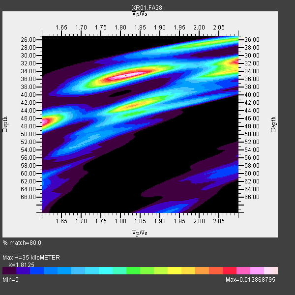
| Thickness Estimate: | 35 km |
| Thickness StdDev: | 6.1 km |
| Vp/Vs Estimate: | 1.81 |
| Vp/Vs StdDev: | 0.17 |
| Vs Estimate: | 3.577 km/s |
| Poisson's Ratio: | 0.28 |
| Peak Value: | 0.01 |
| Assumed Vp: | 6.483 km/s |
| Ps Weight: | 0.33333334 |
| PpPs Weight: | 0.33333334 |
| PsPs Weight: | 0.33333328 |
| Residual Complexity: | 0.763 |
| Nearby stations H: | +- |
| (2.0 deg) Vp/Vs: | +- |
18 with match > 90% ( 69.23077 %) and 26 with match > 80% ( 100.0 %) out of 26.
Download stack as xyz text file.
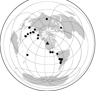
Azimuth Distribution of Events:
Prior Results for this Station
| Study | Thickness | Vp/Vs | Vp | Vs | Poissons Ratio | Extra |
| EARS | 35 km | 1.81 | 6.483 km/s | 3.577 km/s | 0.28 | |
| Crust2.0 | 46 km | 1.78 | 6.483 km/s | 3.648 km/s | 0.27 | D5,thick Platform 2 km seds. |
| Global Maxima | 35 km | 1.81 | 6.483 km/s | 3.577 km/s | 0.28 | amp=0.012868795 |
| Local Maxima 1 | 47 km | 1.60 | 6.483 km/s | 4.052 km/s | 0.18 | amp=0.011743138 |
| Local Maxima 2 | 31 km | 2.10 | 6.483 km/s | 3.091 km/s | 0.35 | amp=0.00910624 |
| Local Maxima 3 | 34 km | 2.09 | 6.483 km/s | 3.098 km/s | 0.35 | amp=0.008172237 |
| Local Maxima 4 | 42 km | 1.84 | 6.483 km/s | 3.518 km/s | 0.29 | amp=0.007258603 |
| Predicted Arrivals for vertical incidence (zero ray parameter) | |
| Ps | 4.39 SECOND |
| PpPs | 15.18 SECOND |
| PsPs/PpSs | 19.57 SECOND |
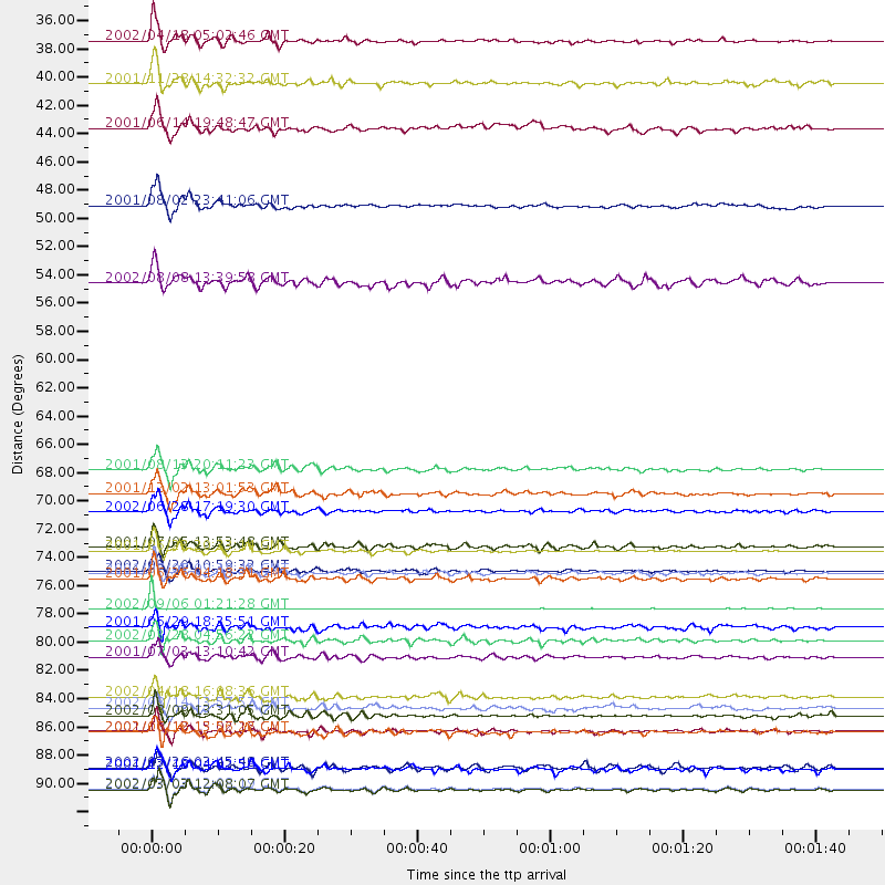
Events Processed for this Station
Download zip of receiver functions as SAC
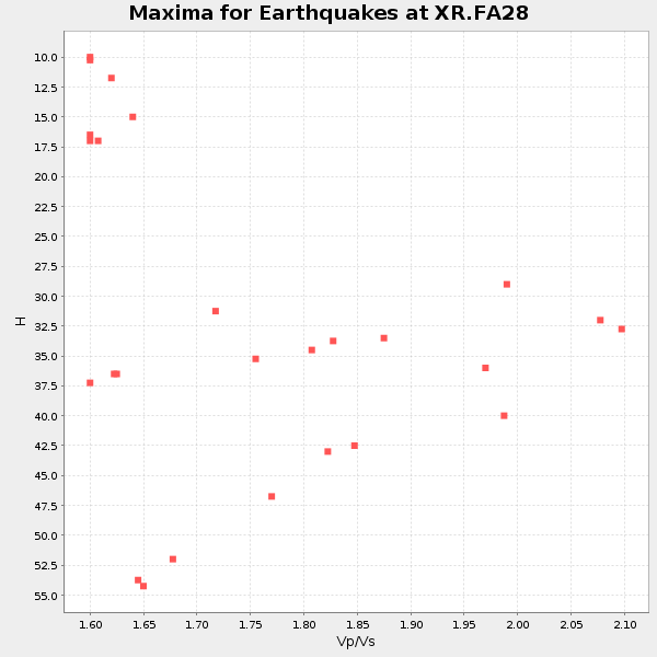
Plot maxima for each earthquake.
Events Used in the Stack
(26 events)| Radial Match | Distance | Baz | FERegion | Time | Lat/Lon | Depth | Magnitude |
| 99.55666 | 79.1 deg | 40.836 deg | Sicily, Italy | 2002/09/06 01:21:28 GMT | (38.4, 13.7) | 5.0 km | 5.8 MB, 5.5 MS, 5.9 MW, 5.9 MW |
| 97.76304 | 88.6 deg | 288.337 deg | South Of Mariana Islands | 2001/10/12 15:02:16 GMT | (12.7, 145.0) | 37 km | 6.7 MB, 7.3 MS, 7.0 MW, 6.9 MW |
| 97.7135 | 71.5 deg | 317.472 deg | E. Russia-N.E. China Border Reg. | 2002/06/28 17:19:30 GMT | (43.8, 130.7) | 566 km | 6.7 MB, 7.3 MW, 7.3 MW |
| 97.59438 | 93.1 deg | 358.382 deg | Hindu Kush Region, Afghanistan | 2002/03/03 12:08:19 GMT | (36.5, 70.5) | 226 km | 6.6 MB, 7.4 MW, 7.3 MW |
| 97.42472 | 76.3 deg | 141.4 deg | Near Coast Of Peru | 2001/07/07 09:38:43 GMT | (-17.5, -72.1) | 33 km | 6.6 MB, 7.3 MS, 7.6 MW, 7.5 ME |
| 97.122406 | 93.2 deg | 358.416 deg | Hindu Kush Region, Afghanistan | 2002/03/03 12:08:07 GMT | (36.4, 70.4) | 209 km | 6.3 MB |
| 96.379555 | 74.5 deg | 142.273 deg | Near Coast Of Peru | 2001/06/23 20:33:14 GMT | (-16.3, -73.6) | 33 km | 6.7 MB, 8.2 MS, 8.4 MW, 7.8 ME |
| 96.213264 | 34.8 deg | 161.916 deg | Near Coast Of Guerrero, Mexico | 2002/04/18 05:02:46 GMT | (17.0, -100.9) | 25 km | 5.4 MB, 6.0 MS, 6.3 MW, 6.1 MW |
| 95.63319 | 76.7 deg | 141.105 deg | Near Coast Of Peru | 2001/06/26 04:18:31 GMT | (-17.7, -71.6) | 24 km | 6.2 MB, 6.7 MS, 6.8 MW, 6.7 ME |
| 95.43677 | 76.1 deg | 301.968 deg | Southeast Of Honshu, Japan | 2002/08/20 10:59:32 GMT | (31.0, 142.0) | 9.0 km | 5.4 MB, 6.2 MS, 6.3 MW, 6.1 MW |
| 93.8986 | 38.1 deg | 150.44 deg | Near Coast Of Chiapas, Mexico | 2001/11/28 14:32:32 GMT | (15.6, -93.1) | 85 km | 5.7 MB, 6.4 MW, 6.4 MW |
| 93.753494 | 81.5 deg | 139.93 deg | Chile-Bolivia Border Region | 2002/03/28 04:56:22 GMT | (-21.7, -68.3) | 125 km | 6.1 MB, 6.5 MW, 6.5 MW |
| 93.39593 | 47.6 deg | 311.242 deg | Near East Coast Of Kamchatka | 2001/08/02 23:41:06 GMT | (56.3, 163.8) | 14 km | 5.9 MB, 6.2 MS, 6.3 MW, 6.2 ME |
| 93.177414 | 74.2 deg | 142.514 deg | Near Coast Of Peru | 2001/07/05 13:53:48 GMT | (-16.1, -74.0) | 62 km | 6.2 MB, 6.6 MW, 6.5 ME |
| 93.176216 | 68.2 deg | 308.514 deg | Hokkaido, Japan Region | 2001/08/13 20:11:23 GMT | (41.0, 142.3) | 38 km | 6.0 MB, 6.3 MS, 6.4 MW, 6.3 ME |
| 93.14758 | 88.7 deg | 146.097 deg | Near Coast Of Central Chile | 2002/06/18 13:56:22 GMT | (-30.8, -71.1) | 54 km | 6.0 MB, 6.6 MW, 6.4 MW |
| 91.16475 | 85.9 deg | 144.316 deg | Near Coast Of Northern Chile | 2002/04/18 16:08:36 GMT | (-27.5, -70.6) | 62 km | 6.2 MB, 6.7 MW, 6.6 MW |
| 90.070755 | 86.8 deg | 288.277 deg | Mariana Islands | 2002/08/14 13:57:52 GMT | (14.1, 146.2) | 30 km | 6.1 MB, 6.4 MS, 6.5 MW, 6.4 MW |
| 88.46244 | 82.8 deg | 295.353 deg | Mariana Islands Region | 2001/07/03 13:10:42 GMT | (21.6, 143.0) | 290 km | 6.0 MB, 6.5 MW, 6.5 MW |
| 86.483215 | 41.6 deg | 298.188 deg | Andreanof Islands, Aleutian Is. | 2001/06/14 19:48:47 GMT | (51.2, -179.8) | 18 km | 6.0 MB, 6.3 MS, 6.5 MW, 6.1 ML |
| 85.215904 | 53.6 deg | 136.64 deg | Near West Coast Of Colombia | 2002/08/08 13:39:58 GMT | (5.0, -77.8) | 43 km | 5.4 MB, 5.0 MS, 5.9 MW, 5.7 MW |
| 84.93204 | 70.0 deg | 308.129 deg | Eastern Honshu, Japan | 2001/12/02 13:01:53 GMT | (39.4, 141.1) | 124 km | 6.1 MB, 6.5 MW, 6.5 MW |
| 84.80854 | 91.4 deg | 310.648 deg | Southwestern Ryukyu Isl., Japan | 2002/03/26 03:45:48 GMT | (23.3, 124.1) | 33 km | 5.8 MB, 6.6 MS, 6.4 MW, 6.4 MW |
| 83.43029 | 91.6 deg | 312.026 deg | Taiwan Region | 2001/12/18 04:02:58 GMT | (24.0, 122.7) | 14 km | 6.3 MB, 7.3 MS, 6.9 MW, 6.8 MW |
| 80.522934 | 87.4 deg | 240.307 deg | Fiji Islands Region | 2002/08/09 13:31:05 GMT | (-16.3, -176.2) | 364 km | 5.5 MB, 6.1 MW, 6.1 MW |
| 80.28809 | 80.5 deg | 137.203 deg | Southern Bolivia | 2001/06/29 18:35:51 GMT | (-19.5, -66.3) | 274 km | 5.7 MB, 6.1 MW, 6.1 MW |
Losers
(0 events)| Radial Match | Distance | Baz | FERegion | Time | Lat/Lon | Depth | Magnitude | Reason |
