
Station XR HH01 - Aiken, SC
Network: XR12 - Deployment of a simultaneous broadband gradiometers to quantify the effects of a
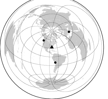
Nearby stations (2 deg radius)
| Station | Name | (Lat, Lon) | Start / End | Elevation |
| HH01 | Aiken, SC | (33.45, -81.77) | 2013-11-27 / 2014-06-04 | 130 m |
| Crust2 Type: | DG,thin Platform 1 km seds. |
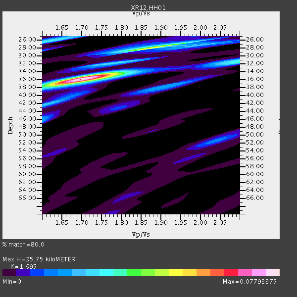
| Thickness Estimate: | 36 km |
| Thickness StdDev: | 3.6 km |
| Vp/Vs Estimate: | 1.70 |
| Vp/Vs StdDev: | 0.09 |
| Vs Estimate: | 3.873 km/s |
| Poisson's Ratio: | 0.23 |
| Peak Value: | 0.08 |
| Assumed Vp: | 6.565 km/s |
| Ps Weight: | 0.33333334 |
| PpPs Weight: | 0.33333334 |
| PsPs Weight: | 0.33333328 |
| Residual Complexity: | 0.484 |
| Nearby stations H: | 36 km +- 0.5 km |
| (2.0 deg) Vp/Vs: | 1.70 +- 0.04 |
0 with match > 90% ( 0.0 %) and 4 with match > 80% ( 12.5 %) out of 32.
Download stack as xyz text file.
Azimuth Distribution of Events:
Prior Results for this Station
| Study | Thickness | Vp/Vs | Vp | Vs | Poissons Ratio | Extra |
| EARS | 36 km | 1.70 | 6.565 km/s | 3.873 km/s | 0.23 | |
| Crust2.0 | 31 km | 1.78 | 6.565 km/s | 3.684 km/s | 0.27 | DG,thin Platform 1 km seds. |
| Global Maxima | 36 km | 1.70 | 6.565 km/s | 3.873 km/s | 0.23 | amp=0.07793375 |
| Local Maxima 1 | 28 km | 1.87 | 6.565 km/s | 3.506 km/s | 0.30 | amp=0.046933364 |
| Local Maxima 2 | 26 km | 1.62 | 6.565 km/s | 4.046 km/s | 0.19 | amp=0.027563402 |
| Local Maxima 3 | 38 km | 1.91 | 6.565 km/s | 3.437 km/s | 0.31 | amp=0.019270802 |
| Local Maxima 4 | 46 km | 1.60 | 6.565 km/s | 4.103 km/s | 0.18 | amp=0.018010374 |
| Predicted Arrivals for vertical incidence (zero ray parameter) | |
| Ps | 3.78 SECOND |
| PpPs | 14.68 SECOND |
| PsPs/PpSs | 18.46 SECOND |
Events Processed for this Station
Download zip of receiver functions as SAC
Plot maxima for each earthquake.
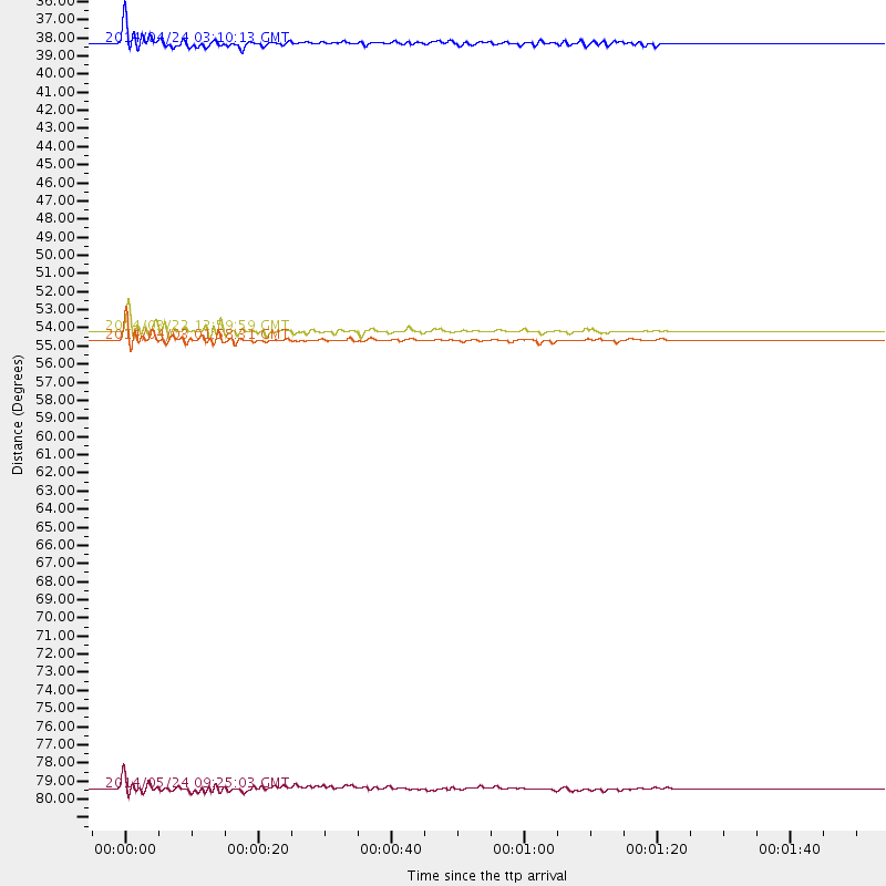
Events Used in the Stack
(4 events)| Radial Match | Distance | Baz | FERegion | Time | Lat/Lon | Depth | Magnitude |
| 89.54508 | 37.2 deg | 310.036 deg | Vancouver Island, Canada Region | 2014/04/24 03:10:13 GMT | (49.8, -127.4) | 11 km | 6.7 MWP, 6.7 MI |
| 85.988556 | 53.9 deg | 167.279 deg | Near Coast Of Northern Chile | 2014/03/22 12:59:59 GMT | (-19.8, -70.9) | 20 km | 6.2 MWW, 6.2 MWB, 6.3 MWC, 6.4 MWC |
| 84.177124 | 54.5 deg | 167.04 deg | Near Coast Of Northern Chile | 2014/04/03 01:58:31 GMT | (-20.3, -70.6) | 23 km | 6.5 MWW, 6.5 MWB, 6.6 MWC |
| 82.81713 | 80.5 deg | 47.77 deg | Aegean Sea | 2014/05/24 09:25:03 GMT | (40.3, 25.5) | 10 km | 6.4 MWP, 6.4 M |
Losers
(28 events)| Radial Match | Distance | Baz | FERegion | Time | Lat/Lon | Depth | Magnitude | Reason |
| 96.79219 | 53.8 deg | 167.185 deg | Near Coast Of Northern Chile | 2014/04/01 23:46:46 GMT | (-19.6, -70.8) | 20 km | 8.2 MWW, 8.0 MI, 8.1 MWC | |
| 91.55607 | 54.7 deg | 167.036 deg | Near Coast Of Northern Chile | 2014/04/03 02:43:14 GMT | (-20.5, -70.5) | 31 km | 7.7 MWW, 7.4 MI, 7.7 MWC | |
| 89.76388 | 53.8 deg | 166.809 deg | Near Coast Of Northern Chile | 2014/04/02 00:04:54 GMT | (-19.6, -70.5) | 34 km | 5.5 MB | |
| 87.22124 | 35.1 deg | 294.897 deg | Off Coast Of Northern California | 2014/03/10 05:18:13 GMT | (40.8, -125.1) | 17 km | 6.8 MW, 6.8 MWR, 6.9 MWW, 6.9 MWB, 7.0 MI, 7.0 MWC | |
| 84.856186 | 53.8 deg | 166.403 deg | Near Coast Of Northern Chile | 2014/04/01 23:59:57 GMT | (-19.5, -70.2) | 22 km | 5.8 MB | |
| 75.28714 | 55.0 deg | 167.163 deg | Near Coast Of Northern Chile | 2014/04/03 05:26:16 GMT | (-20.8, -70.5) | 24 km | 6.2 MWP, 6.2 MWR, 6.3 MWW, 6.5 MWC | |
| 74.23333 | 53.5 deg | 167.047 deg | Near Coast Of Northern Chile | 2014/04/02 02:52:26 GMT | (-19.3, -70.8) | 17 km | 4.9 mb | |
| 73.89824 | 47.7 deg | 171.904 deg | Near Coast Of Peru | 2014/02/18 23:35:58 GMT | (-14.2, -75.6) | 57 km | 6.0 MWB, 5.9 MWW, 5.9 MWC, 6.0 MWC | |
| 71.51319 | 88.1 deg | 200.038 deg | Southern East Pacific Rise | 2014/04/09 08:29:25 GMT | (-50.3, -114.0) | 10 km | 5.6 MW | |
| 70.76073 | 53.9 deg | 167.202 deg | Near Coast Of Northern Chile | 2014/03/23 18:20:03 GMT | (-19.7, -70.8) | 35 km | 6.0 MB, 6.2 MWB, 6.2 MWW, 6.3 MWC | |
| 63.278828 | 56.0 deg | 333.001 deg | Northern Alaska | 2014/04/18 18:56:47 GMT | (67.7, -162.5) | 17 km | 5.7 MW | |
| 62.308563 | 52.0 deg | 323.101 deg | Southern Alaska | 2014/05/10 14:16:08 GMT | (60.0, -152.2) | 96 km | 5.8 ML, 5.5 MI, 5.7 MWP | |
| 62.107716 | 54.2 deg | 167.372 deg | Near Coast Of Northern Chile | 2014/05/17 09:11:06 GMT | (-20.0, -70.9) | 13 km | 5.5 MB | |
| 62.106045 | 55.9 deg | 332.896 deg | Northern Alaska | 2014/05/03 08:57:12 GMT | (67.6, -162.2) | 0.9 km | 5.5 MB | |
| 59.975574 | 68.8 deg | 171.384 deg | Central Chile | 2014/03/04 11:24:20 GMT | (-35.0, -72.0) | 48 km | 4.9 mb | |
| 59.367287 | 67.1 deg | 170.485 deg | Near Coast Of Central Chile | 2014/03/06 04:37:05 GMT | (-33.3, -71.3) | 59 km | 5.4 MW | |
| 58.61086 | 74.7 deg | 326.512 deg | Komandorskiye Ostrova Region | 2014/05/31 06:16:56 GMT | (55.0, 165.7) | 20 km | 5.5 MW | |
| 58.210567 | 63.9 deg | 318.42 deg | Fox Islands, Aleutian Islands | 2014/02/26 21:13:40 GMT | (53.6, -171.8) | 265 km | 6.1 MWW, 5.9 MI, 5.9 ML, 6.1 MWC, 6.1 MWB, 6.2 MWC | |
| 57.612904 | 69.0 deg | 318.046 deg | Andreanof Islands, Aleutian Is. | 2014/01/16 07:33:09 GMT | (51.2, -179.2) | 27 km | 5.5 MWB, 5.2 ML, 5.5 ML, 5.6 MWC | |
| 54.573307 | 54.3 deg | 167.347 deg | Near Coast Of Northern Chile | 2014/04/02 04:46:18 GMT | (-20.2, -70.9) | 10 km | 5.8 MB | |
| 53.392307 | 70.8 deg | 192.727 deg | West Chile Rise | 2014/05/06 20:52:29 GMT | (-36.3, -96.7) | 14 km | 5.9 MWB | |
| 51.899555 | 30.8 deg | 168.552 deg | Colombia | 2014/01/09 12:50:16 GMT | (3.0, -75.9) | 15 km | 5.0 MW | |
| 51.332825 | 72.6 deg | 103.391 deg | North Of Ascension Island | 2014/04/30 15:52:42 GMT | (-1.2, -13.5) | 14 km | 5.8 MW | |
| 48.267788 | 53.8 deg | 167.356 deg | Near Coast Of Northern Chile | 2014/05/14 05:51:50 GMT | (-19.7, -71.0) | 27 km | 5.3 MW | |
| 43.643642 | 79.6 deg | 114.608 deg | Southern Mid-Atlantic Ridge | 2014/02/20 04:09:57 GMT | (-14.1, -14.6) | 14 km | 5.1 MW | |
| 42.93159 | 90.1 deg | 326.606 deg | Kuril Islands | 2014/05/05 14:38:25 GMT | (44.4, 148.4) | 82 km | 4.2 mb | |
| 40.064377 | 54.8 deg | 167.332 deg | Near Coast Of Northern Chile | 2014/04/04 01:37:51 GMT | (-20.6, -70.7) | 20 km | 6.1 MWP, 6.1 MWB, 6.1 MWW, 6.3 MWC | |
| 32.24409 | 67.1 deg | 171.312 deg | Off Coast Of Central Chile | 2014/04/11 01:08:01 GMT | (-33.4, -72.2) | 12 km | 5.0 mb |

