
Station XR HH03 - Aiken, SC
Network: XR12 - Deployment of a simultaneous broadband gradiometers to quantify the effects of a
Nearby stations (2 deg radius)
| Station | Name | (Lat, Lon) | Start / End | Elevation |
| HH03 | Aiken, SC | (33.45, -81.77) | 2013-11-27 / 2014-06-04 | 127 m |
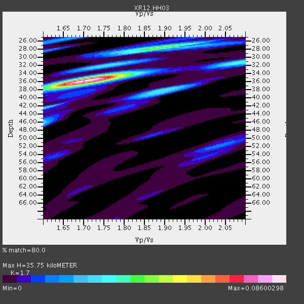
| Crust2 Type: | DG,thin Platform 1 km seds. |
| Thickness Estimate: | 36 km |
| Thickness StdDev: | 2.4 km |
| Vp/Vs Estimate: | 1.70 |
| Vp/Vs StdDev: | 0.06 |
| Vs Estimate: | 3.861 km/s |
| Poisson's Ratio: | 0.24 |
| Peak Value: | 0.09 |
| Assumed Vp: | 6.565 km/s |
| Ps Weight: | 0.33333334 |
| PpPs Weight: | 0.33333334 |
| PsPs Weight: | 0.33333328 |
| Residual Complexity: | 0.502 |
| Nearby stations H: | 36 km +- 0.5 km |
| (2.0 deg) Vp/Vs: | 1.70 +- 0.04 |
0 with match > 90% ( 0.0 %) and 4 with match > 80% ( 14.814815 %) out of 27.
Download stack as xyz text file.
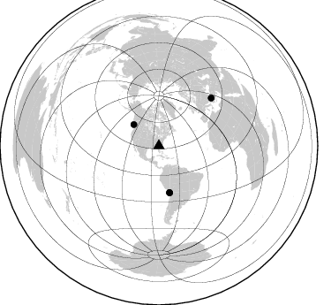
Azimuth Distribution of Events:
Prior Results for this Station
| Study | Thickness | Vp/Vs | Vp | Vs | Poissons Ratio | Extra |
| EARS | 36 km | 1.70 | 6.565 km/s | 3.861 km/s | 0.24 | |
| Crust2.0 | 31 km | 1.78 | 6.565 km/s | 3.684 km/s | 0.27 | DG,thin Platform 1 km seds. |
| Global Maxima | 36 km | 1.70 | 6.565 km/s | 3.861 km/s | 0.24 | amp=0.08600298 |
| Local Maxima 1 | 28 km | 1.89 | 6.565 km/s | 3.473 km/s | 0.31 | amp=0.044052463 |
| Local Maxima 2 | 38 km | 1.90 | 6.565 km/s | 3.46 km/s | 0.31 | amp=0.029901832 |
| Local Maxima 3 | 46 km | 1.60 | 6.565 km/s | 4.103 km/s | 0.18 | amp=0.025648138 |
| Local Maxima 4 | 26 km | 1.65 | 6.565 km/s | 3.985 km/s | 0.21 | amp=0.021644372 |
| Predicted Arrivals for vertical incidence (zero ray parameter) | |
| Ps | 3.81 SECOND |
| PpPs | 14.70 SECOND |
| PsPs/PpSs | 18.52 SECOND |
Events Processed for this Station
Download zip of receiver functions as SAC
Plot maxima for each earthquake.
Events Used in the Stack
(4 events)| Radial Match | Distance | Baz | FERegion | Time | Lat/Lon | Depth | Magnitude |
| 89.73908 | 37.2 deg | 310.036 deg | Vancouver Island, Canada Region | 2014/04/24 03:10:13 GMT | (49.8, -127.4) | 11 km | 6.7 MWP, 6.7 MI |
| 85.81152 | 53.9 deg | 167.278 deg | Near Coast Of Northern Chile | 2014/03/22 12:59:59 GMT | (-19.8, -70.9) | 20 km | 6.2 MWW, 6.2 MWB, 6.3 MWC, 6.4 MWC |
| 83.29101 | 54.5 deg | 167.039 deg | Near Coast Of Northern Chile | 2014/04/03 01:58:31 GMT | (-20.3, -70.6) | 23 km | 6.5 MWW, 6.5 MWB, 6.6 MWC |
| 83.21383 | 80.5 deg | 47.77 deg | Aegean Sea | 2014/05/24 09:25:03 GMT | (40.3, 25.5) | 10 km | 6.4 MWP, 6.4 M |
Losers
(23 events)| Radial Match | Distance | Baz | FERegion | Time | Lat/Lon | Depth | Magnitude | Reason |
| 96.82201 | 53.8 deg | 167.184 deg | Near Coast Of Northern Chile | 2014/04/01 23:46:46 GMT | (-19.6, -70.8) | 20 km | 8.2 MWW, 8.0 MI, 8.1 MWC | |
| 90.84294 | 54.7 deg | 167.035 deg | Near Coast Of Northern Chile | 2014/04/03 02:43:14 GMT | (-20.5, -70.5) | 31 km | 7.7 MWW, 7.4 MI, 7.7 MWC | |
| 88.7321 | 53.8 deg | 166.808 deg | Near Coast Of Northern Chile | 2014/04/02 00:04:54 GMT | (-19.6, -70.5) | 34 km | 5.5 MB | |
| 87.242584 | 35.1 deg | 294.897 deg | Off Coast Of Northern California | 2014/03/10 05:18:13 GMT | (40.8, -125.1) | 17 km | 6.8 MW, 6.8 MWR, 6.9 MWW, 6.9 MWB, 7.0 MI, 7.0 MWC | |
| 84.108696 | 53.8 deg | 166.402 deg | Near Coast Of Northern Chile | 2014/04/01 23:59:57 GMT | (-19.5, -70.2) | 22 km | 5.8 MB | |
| 79.99006 | 54.8 deg | 167.331 deg | Near Coast Of Northern Chile | 2014/04/04 01:37:51 GMT | (-20.6, -70.7) | 20 km | 6.1 MWP, 6.1 MWB, 6.1 MWW, 6.3 MWC | |
| 76.57178 | 58.0 deg | 165.689 deg | Northern Chile | 2014/05/16 17:08:32 GMT | (-23.5, -68.6) | 103 km | 5.5 MWR | |
| 76.01792 | 55.0 deg | 167.162 deg | Near Coast Of Northern Chile | 2014/04/03 05:26:16 GMT | (-20.8, -70.5) | 24 km | 6.2 MWP, 6.2 MWR, 6.3 MWW, 6.5 MWC | |
| 75.18162 | 53.5 deg | 167.046 deg | Near Coast Of Northern Chile | 2014/04/02 02:52:26 GMT | (-19.3, -70.8) | 17 km | 4.9 mb | |
| 73.438965 | 47.7 deg | 171.904 deg | Near Coast Of Peru | 2014/02/18 23:35:58 GMT | (-14.2, -75.6) | 57 km | 6.0 MWB, 5.9 MWW, 5.9 MWC, 6.0 MWC | |
| 73.08019 | 53.9 deg | 167.201 deg | Near Coast Of Northern Chile | 2014/03/23 18:20:03 GMT | (-19.7, -70.8) | 35 km | 6.0 MB, 6.2 MWB, 6.2 MWW, 6.3 MWC | |
| 73.01421 | 52.0 deg | 323.101 deg | Southern Alaska | 2014/05/10 14:16:08 GMT | (60.0, -152.2) | 96 km | 5.8 ML, 5.5 MI, 5.7 MWP | |
| 69.43733 | 88.1 deg | 200.038 deg | Southern East Pacific Rise | 2014/04/09 08:29:25 GMT | (-50.3, -114.0) | 10 km | 5.6 MW | |
| 63.727192 | 56.0 deg | 333.001 deg | Northern Alaska | 2014/04/18 18:56:47 GMT | (67.7, -162.5) | 17 km | 5.7 MW | |
| 63.206146 | 67.1 deg | 170.484 deg | Near Coast Of Central Chile | 2014/03/06 04:37:05 GMT | (-33.3, -71.3) | 59 km | 5.4 MW | |
| 59.283356 | 74.7 deg | 326.512 deg | Komandorskiye Ostrova Region | 2014/05/31 06:16:56 GMT | (55.0, 165.7) | 20 km | 5.5 MW | |
| 58.972862 | 63.9 deg | 318.42 deg | Fox Islands, Aleutian Islands | 2014/02/26 21:13:40 GMT | (53.6, -171.8) | 265 km | 6.1 MWW, 5.9 MI, 5.9 ML, 6.1 MWC, 6.1 MWB, 6.2 MWC | |
| 58.893517 | 69.0 deg | 318.046 deg | Andreanof Islands, Aleutian Is. | 2014/01/16 07:33:09 GMT | (51.2, -179.2) | 27 km | 5.5 MWB, 5.2 ML, 5.5 ML, 5.6 MWC | |
| 58.614944 | 54.3 deg | 167.346 deg | Near Coast Of Northern Chile | 2014/04/02 04:46:18 GMT | (-20.2, -70.9) | 10 km | 5.8 MB | |
| 55.166424 | 54.7 deg | 167.28 deg | Near Coast Of Northern Chile | 2014/04/03 09:23:21 GMT | (-20.6, -70.7) | 15 km | 5.6 MB, 5.3 MWR | |
| 49.026447 | 55.9 deg | 332.896 deg | Northern Alaska | 2014/05/03 08:57:12 GMT | (67.6, -162.2) | 0.9 km | 5.5 MB | |
| 28.618105 | 86.3 deg | 325.483 deg | Kuril Islands | 2014/01/08 16:50:28 GMT | (46.5, 153.2) | 40 km | 5.0 mb | |
| 25.223768 | 54.1 deg | 167.434 deg | Near Coast Of Northern Chile | 2014/04/02 11:07:33 GMT | (-20.0, -71.0) | 27 km | 5.4 Mww |

