
Station XR HH05 - Aiken, SC
Network: XR12 - Deployment of a simultaneous broadband gradiometers to quantify the effects of a
Nearby stations (2 deg radius)
| Station | Name | (Lat, Lon) | Start / End | Elevation |
| HH05 | Aiken, SC | (33.45, -81.77) | 2013-11-27 / 2014-06-04 | 134 m |
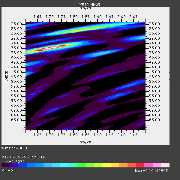
| Crust2 Type: | DG,thin Platform 1 km seds. |
| Thickness Estimate: | 36 km |
| Thickness StdDev: | 1.6 km |
| Vp/Vs Estimate: | 1.71 |
| Vp/Vs StdDev: | 0.05 |
| Vs Estimate: | 3.845 km/s |
| Poisson's Ratio: | 0.24 |
| Peak Value: | 0.10 |
| Assumed Vp: | 6.565 km/s |
| Ps Weight: | 0.33333334 |
| PpPs Weight: | 0.33333334 |
| PsPs Weight: | 0.33333328 |
| Residual Complexity: | 0.641 |
| Nearby stations H: | 36 km +- 0.5 km |
| (2.0 deg) Vp/Vs: | 1.70 +- 0.04 |
1 with match > 90% ( 4.0 %) and 4 with match > 80% ( 16.0 %) out of 25.
Download stack as xyz text file.
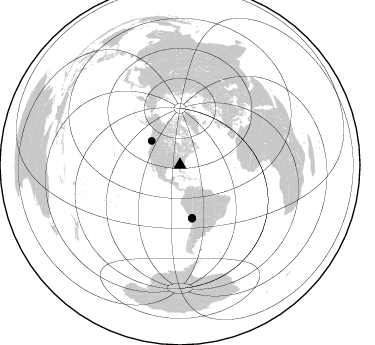
Azimuth Distribution of Events:
Prior Results for this Station
| Study | Thickness | Vp/Vs | Vp | Vs | Poissons Ratio | Extra |
| EARS | 36 km | 1.71 | 6.565 km/s | 3.845 km/s | 0.24 | |
| Crust2.0 | 31 km | 1.78 | 6.565 km/s | 3.684 km/s | 0.27 | DG,thin Platform 1 km seds. |
| Global Maxima | 36 km | 1.71 | 6.565 km/s | 3.845 km/s | 0.24 | amp=0.10492866 |
| Local Maxima 1 | 28 km | 1.83 | 6.565 km/s | 3.587 km/s | 0.29 | amp=0.06471729 |
| Local Maxima 2 | 47 km | 1.60 | 6.565 km/s | 4.103 km/s | 0.18 | amp=0.032972798 |
| Local Maxima 3 | 38 km | 1.91 | 6.565 km/s | 3.432 km/s | 0.31 | amp=0.03149583 |
| Local Maxima 4 | 26 km | 1.94 | 6.565 km/s | 3.379 km/s | 0.32 | amp=0.023035455 |
| Predicted Arrivals for vertical incidence (zero ray parameter) | |
| Ps | 3.85 SECOND |
| PpPs | 14.74 SECOND |
| PsPs/PpSs | 18.60 SECOND |
Events Processed for this Station
Download zip of receiver functions as SAC
Plot maxima for each earthquake.
Events Used in the Stack
(4 events)| Radial Match | Distance | Baz | FERegion | Time | Lat/Lon | Depth | Magnitude |
| 90.231476 | 37.2 deg | 310.036 deg | Vancouver Island, Canada Region | 2014/04/24 03:10:13 GMT | (49.8, -127.4) | 11 km | 6.7 MWP, 6.7 MI |
| 85.66292 | 53.9 deg | 167.276 deg | Near Coast Of Northern Chile | 2014/03/22 12:59:59 GMT | (-19.8, -70.9) | 20 km | 6.2 MWW, 6.2 MWB, 6.3 MWC, 6.4 MWC |
| 82.882996 | 54.5 deg | 167.037 deg | Near Coast Of Northern Chile | 2014/04/03 01:58:31 GMT | (-20.3, -70.6) | 23 km | 6.5 MWW, 6.5 MWB, 6.6 MWC |
| 82.07542 | 54.8 deg | 167.329 deg | Near Coast Of Northern Chile | 2014/04/04 01:37:51 GMT | (-20.6, -70.7) | 20 km | 6.1 MWP, 6.1 MWB, 6.1 MWW, 6.3 MWC |
Losers
(21 events)| Radial Match | Distance | Baz | FERegion | Time | Lat/Lon | Depth | Magnitude | Reason |
| 96.44869 | 53.8 deg | 167.182 deg | Near Coast Of Northern Chile | 2014/04/01 23:46:46 GMT | (-19.6, -70.8) | 20 km | 8.2 MWW, 8.0 MI, 8.1 MWC | |
| 91.59719 | 54.7 deg | 167.033 deg | Near Coast Of Northern Chile | 2014/04/03 02:43:14 GMT | (-20.5, -70.5) | 31 km | 7.7 MWW, 7.4 MI, 7.7 MWC | |
| 89.26547 | 53.8 deg | 166.805 deg | Near Coast Of Northern Chile | 2014/04/02 00:04:54 GMT | (-19.6, -70.5) | 34 km | 5.5 MB | |
| 88.60696 | 35.1 deg | 294.896 deg | Off Coast Of Northern California | 2014/03/10 05:18:13 GMT | (40.8, -125.1) | 17 km | 6.8 MW, 6.8 MWR, 6.9 MWW, 6.9 MWB, 7.0 MI, 7.0 MWC | |
| 84.41709 | 53.8 deg | 166.4 deg | Near Coast Of Northern Chile | 2014/04/01 23:59:57 GMT | (-19.5, -70.2) | 22 km | 5.8 MB | |
| 76.31744 | 55.0 deg | 167.16 deg | Near Coast Of Northern Chile | 2014/04/03 05:26:16 GMT | (-20.8, -70.5) | 24 km | 6.2 MWP, 6.2 MWR, 6.3 MWW, 6.5 MWC | |
| 74.253044 | 53.5 deg | 167.044 deg | Near Coast Of Northern Chile | 2014/04/02 02:52:26 GMT | (-19.3, -70.8) | 17 km | 4.9 mb | |
| 72.31846 | 88.1 deg | 200.037 deg | Southern East Pacific Rise | 2014/04/09 08:29:25 GMT | (-50.3, -114.0) | 10 km | 5.6 MW | |
| 71.18956 | 47.7 deg | 171.901 deg | Near Coast Of Peru | 2014/02/18 23:35:58 GMT | (-14.2, -75.6) | 57 km | 6.0 MWB, 5.9 MWW, 5.9 MWC, 6.0 MWC | |
| 70.67126 | 94.3 deg | 168.936 deg | Drake Passage | 2014/02/27 05:10:58 GMT | (-59.5, -59.8) | 10 km | 5.3 MW | |
| 68.06761 | 52.0 deg | 323.101 deg | Southern Alaska | 2014/05/10 14:16:08 GMT | (60.0, -152.2) | 96 km | 5.8 ML, 5.5 MI, 5.7 MWP | |
| 65.448685 | 77.1 deg | 325.972 deg | Off East Coast Of Kamchatka | 2014/04/20 13:50:41 GMT | (53.1, 163.1) | 36 km | 5.2 MW | |
| 62.85931 | 67.1 deg | 170.482 deg | Near Coast Of Central Chile | 2014/03/06 04:37:05 GMT | (-33.3, -71.3) | 59 km | 5.4 MW | |
| 62.185333 | 55.9 deg | 332.896 deg | Northern Alaska | 2014/05/03 08:57:12 GMT | (67.6, -162.2) | 0.9 km | 5.5 MB | |
| 61.197666 | 63.9 deg | 318.419 deg | Fox Islands, Aleutian Islands | 2014/02/26 21:13:40 GMT | (53.6, -171.8) | 265 km | 6.1 MWW, 5.9 MI, 5.9 ML, 6.1 MWC, 6.1 MWB, 6.2 MWC | |
| 60.02202 | 69.0 deg | 318.045 deg | Andreanof Islands, Aleutian Is. | 2014/01/16 07:33:09 GMT | (51.2, -179.2) | 27 km | 5.5 MWB, 5.2 ML, 5.5 ML, 5.6 MWC | |
| 59.05413 | 56.9 deg | 165.646 deg | Northern Chile | 2014/02/12 11:43:10 GMT | (-22.4, -68.8) | 100 km | 5.6 MWW, 5.6 MWR | |
| 56.383663 | 54.9 deg | 167.238 deg | Near Coast Of Northern Chile | 2014/01/06 03:59:02 GMT | (-20.7, -70.6) | 27 km | 5.2 MW | |
| 53.624992 | 54.3 deg | 167.344 deg | Near Coast Of Northern Chile | 2014/04/02 04:46:18 GMT | (-20.2, -70.9) | 10 km | 5.8 MB | |
| 46.53186 | 79.1 deg | 176.318 deg | Off Coast Of Southern Chile | 2014/03/02 16:18:30 GMT | (-45.9, -76.6) | 23 km | 5.0 MW | |
| 22.729979 | 30.8 deg | 168.546 deg | Colombia | 2014/01/09 12:50:16 GMT | (3.0, -75.9) | 15 km | 5.0 MW |

