
Station XR BB08 - Yaba
Network: XR94 - INDEPTH II
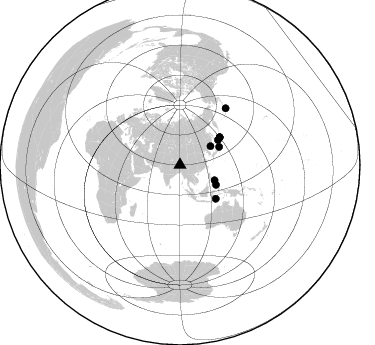
Nearby stations (2 deg radius)
| Station | Name | (Lat, Lon) | Start / End | Elevation |
| BB08 | Yaba | (30.13, 90.55) | 1994-06-04 / 1994-12-31 | 4362 m |
| Crust2 Type: | R5,orogen/75km Tibet, 0 km seds. |
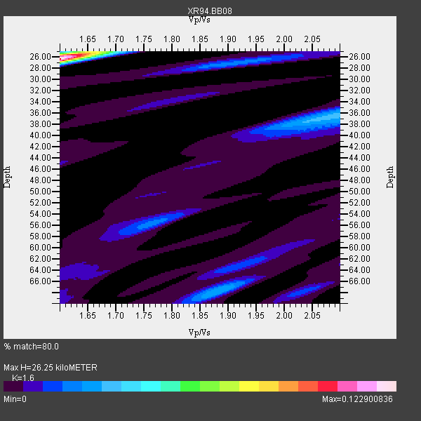
| Thickness Estimate: | 26 km |
| Thickness StdDev: | 0.1 km |
| Vp/Vs Estimate: | 1.60 |
| Vp/Vs StdDev: | 0.00 |
| Vs Estimate: | 4.062 km/s |
| Poisson's Ratio: | 0.18 |
| Peak Value: | 0.12 |
| Assumed Vp: | 6.5 km/s |
| Ps Weight: | 0.33333334 |
| PpPs Weight: | 0.33333334 |
| PsPs Weight: | 0.33333328 |
| Residual Complexity: | 0.620 |
| Nearby stations H: | +- |
| (2.0 deg) Vp/Vs: | +- |
5 with match > 90% ( 50.0 %) and 10 with match > 80% ( 100.0 %) out of 10.
Download stack as xyz text file.
Azimuth Distribution of Events:
Prior Results for this Station
| Study | Thickness | Vp/Vs | Vp | Vs | Poissons Ratio | Extra |
| EARS | 26 km | 1.60 | 6.5 km/s | 4.062 km/s | 0.18 | |
| Crust2.0 | 75 km | 1.76 | 6.5 km/s | 3.7 km/s | 0.26 | R5,orogen/75km Tibet, 0 km seds. |
| Global Maxima | 26 km | 1.60 | 6.5 km/s | 4.062 km/s | 0.18 | amp=0.122900836 |
| Local Maxima 1 | 36 km | 2.10 | 6.5 km/s | 3.099 km/s | 0.35 | amp=0.03432092 |
| Local Maxima 2 | 68 km | 1.88 | 6.5 km/s | 3.457 km/s | 0.30 | amp=0.029954648 |
| Local Maxima 3 | 27 km | 1.91 | 6.5 km/s | 3.394 km/s | 0.31 | amp=0.022223694 |
| Local Maxima 4 | 26 km | 1.60 | 6.5 km/s | 4.062 km/s | 0.18 | amp=0.021780593 |
| Predicted Arrivals for vertical incidence (zero ray parameter) | |
| Ps | 2.42 SECOND |
| PpPs | 10.50 SECOND |
| PsPs/PpSs | 12.92 SECOND |
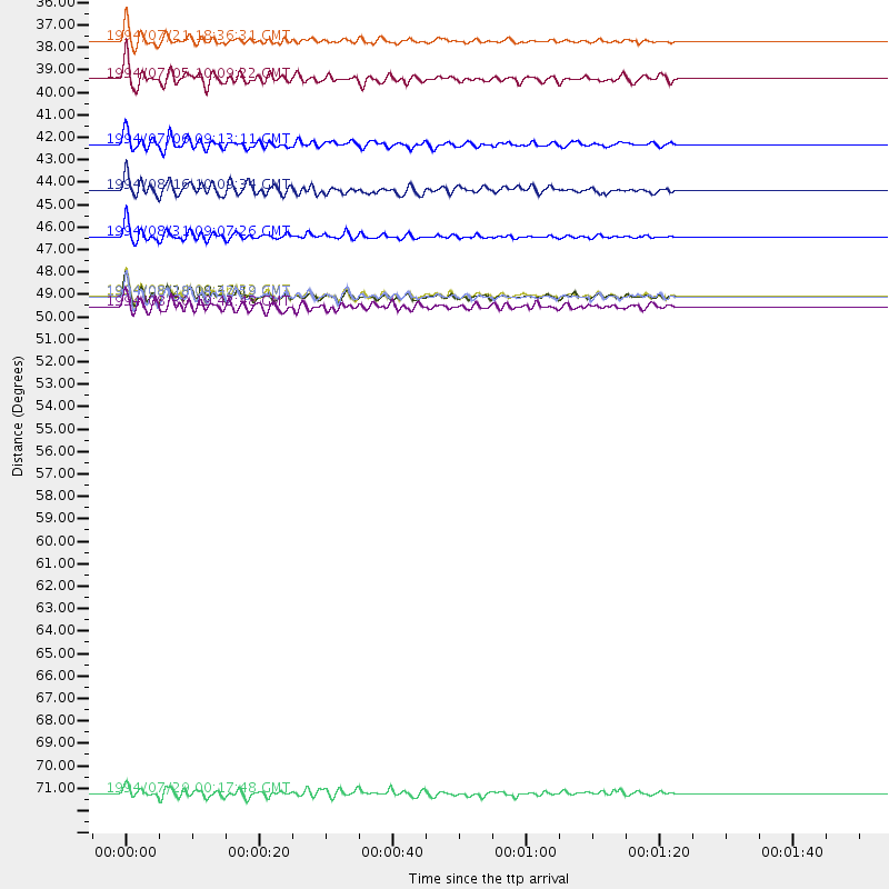
Events Processed for this Station
Download zip of receiver functions as SAC
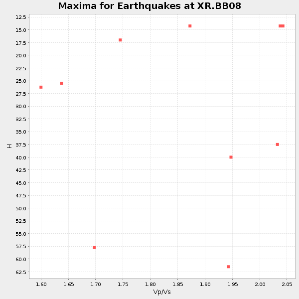
Plot maxima for each earthquake.
Events Used in the Stack
(10 events)| Radial Match | Distance | Baz | FERegion | Time | Lat/Lon | Depth | Magnitude |
| 94.53189 | 48.5 deg | 55.215 deg | East Of Kuril Islands | 1994/08/28 18:37:19 GMT | (44.7, 150.2) | 14 km | 6.0 MB, 6.5 MS, 6.3 UNKNOWN, 6.7 MW |
| 93.52431 | 48.5 deg | 55.288 deg | East Of Kuril Islands | 1994/08/14 00:46:22 GMT | (44.7, 150.1) | 33 km | 5.9 MB, 5.8 MS, 5.4 UNKNOWN, 6.1 MW |
| 92.06677 | 48.5 deg | 55.262 deg | East Of Kuril Islands | 1994/08/18 04:42:59 GMT | (44.7, 150.2) | 33 km | 6.1 MB, 6.5 MS, 6.6 UNKNOWN, 6.5 MW |
| 90.91039 | 35.9 deg | 58.429 deg | Primor'ye, Russia | 1994/07/21 18:36:31 GMT | (42.3, 132.9) | 473 km | 6.4 MB, 7.2 UNKNOWN |
| 90.64255 | 43.3 deg | 65.417 deg | Off East Coast Of Honshu, Japan | 1994/08/16 10:09:34 GMT | (37.8, 142.5) | 34 km | 5.8 MB, 5.2 MS, 5.1 UNKNOWN, 5.8 MW |
| 88.48285 | 41.0 deg | 118.72 deg | Mindanao, Philippines | 1994/07/06 09:13:11 GMT | (6.0, 125.9) | 164 km | 5.7 MB, 6.1 UNKNOWN |
| 87.3582 | 45.6 deg | 56.795 deg | Hokkaido, Japan Region | 1994/08/31 09:07:26 GMT | (43.7, 146.0) | 80 km | 5.9 MB, 6.2 UNKNOWN, 6.2 MW |
| 82.31137 | 49.0 deg | 133.29 deg | Banda Sea | 1994/08/30 19:42:48 GMT | (-7.0, 124.2) | 618 km | 5.8 MB, 6.4 UNKNOWN, 6.2 MW |
| 81.89338 | 73.0 deg | 38.948 deg | Fox Islands, Aleutian Islands | 1994/07/29 00:17:48 GMT | (52.4, -168.3) | 33 km | 5.9 MB, 5.6 MS, 5.8 UNKNOWN, 5.6 ML |
| 81.583435 | 37.8 deg | 113.91 deg | Leyte, Philippines | 1994/07/05 10:09:22 GMT | (10.4, 125.3) | 30 km | 5.4 MB, 5.5 MS |
Losers
(0 events)| Radial Match | Distance | Baz | FERegion | Time | Lat/Lon | Depth | Magnitude | Reason |
