
Station XR BB34 - Paena
Network: XR94 - INDEPTH II
Nearby stations (2 deg radius)
| Station | Name | (Lat, Lon) | Start / End | Elevation |
| BB34 | Paena | (29.11, 89.25) | 1994-06-08 / 1994-12-31 | 4003 m |
| Crust2 Type: | RD,orogen/70km Tibet, no seds. |
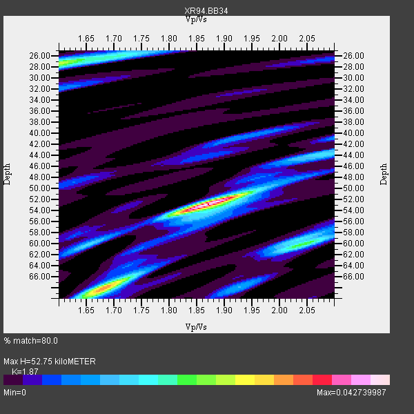
| Thickness Estimate: | 53 km |
| Thickness StdDev: | 11 km |
| Vp/Vs Estimate: | 1.87 |
| Vp/Vs StdDev: | 0.14 |
| Vs Estimate: | 3.484 km/s |
| Poisson's Ratio: | 0.30 |
| Peak Value: | 0.04 |
| Assumed Vp: | 6.514 km/s |
| Ps Weight: | 0.33333334 |
| PpPs Weight: | 0.33333334 |
| PsPs Weight: | 0.33333328 |
| Residual Complexity: | 0.694 |
| Nearby stations H: | +- |
| (2.0 deg) Vp/Vs: | +- |
1 with match > 90% ( 16.666666 %) and 6 with match > 80% ( 100.0 %) out of 6.
Download stack as xyz text file.
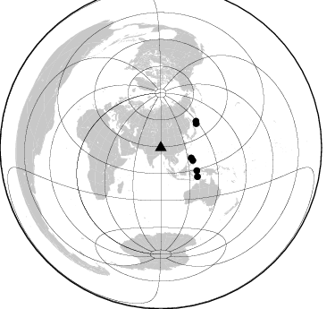
Azimuth Distribution of Events:
Prior Results for this Station
| Study | Thickness | Vp/Vs | Vp | Vs | Poissons Ratio | Extra |
| EARS | 53 km | 1.87 | 6.514 km/s | 3.484 km/s | 0.30 | |
| Crust2.0 | 70 km | 1.76 | 6.514 km/s | 3.706 km/s | 0.26 | RD,orogen/70km Tibet, no seds. |
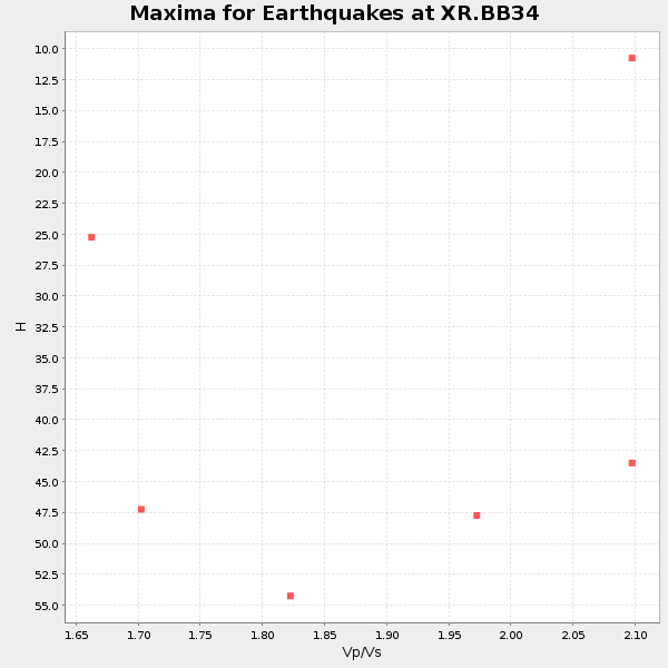
| Global Maxima | 53 km | 1.87 | 6.514 km/s | 3.484 km/s | 0.30 | amp=0.042739987 |
| Local Maxima 1 | 68 km | 1.68 | 6.514 km/s | 3.889 km/s | 0.22 | amp=0.028014572 |
| Local Maxima 2 | 27 km | 1.60 | 6.514 km/s | 4.071 km/s | 0.18 | amp=0.025519412 |
| Local Maxima 3 | 60 km | 2.05 | 6.514 km/s | 3.182 km/s | 0.34 | amp=0.014976208 |
| Local Maxima 4 | 60 km | 1.65 | 6.514 km/s | 3.954 km/s | 0.21 | amp=0.012028317 |
| Predicted Arrivals for vertical incidence (zero ray parameter) | |
| Ps | 7.04 SECOND |
| PpPs | 23.24 SECOND |
| PsPs/PpSs | 30.28 SECOND |
Events Processed for this Station
Download zip of receiver functions as SAC
Plot maxima for each earthquake.
Events Used in the Stack
(6 events)| Radial Match | Distance | Baz | FERegion | Time | Lat/Lon | Depth | Magnitude |
| 92.1095 | 48.0 deg | 55.888 deg | Kuril Islands | 1994/10/04 13:22:58 GMT | (43.7, 147.3) | 33 km | 7.4 MB, 8.1 MS, 8.3 UNKNOWN, 8.2 MW |
| 85.48019 | 49.3 deg | 53.111 deg | Kuril Islands | 1994/10/16 05:10:03 GMT | (45.7, 149.2) | 139 km | 6.3 MB, 6.8 UNKNOWN, 6.7 MW |
| 84.55537 | 38.5 deg | 111.52 deg | Leyte, Philippines | 1994/07/05 10:09:22 GMT | (10.4, 125.3) | 30 km | 5.4 MB, 5.5 MS |
| 84.21804 | 36.1 deg | 108.471 deg | Luzon, Philippines | 1994/06/09 16:22:22 GMT | (13.3, 124.2) | 80 km | 5.8 MB, 6.2 UNKNOWN |
| 83.11703 | 52.1 deg | 128.229 deg | Banda Sea | 1994/07/13 11:45:25 GMT | (-7.5, 127.9) | 185 km | 6.4 MB, 6.8 UNKNOWN, 6.5 MW |
| 81.44751 | 47.8 deg | 122.327 deg | Halmahera, Indonesia | 1994/10/08 21:44:09 GMT | (-1.2, 128.0) | 31 km | 6.3 MB, 6.8 MS, 6.8 UNKNOWN, 6.9 MW |
Losers
(0 events)| Radial Match | Distance | Baz | FERegion | Time | Lat/Lon | Depth | Magnitude | Reason |
