
Station XR LUMP - Lumpola
Network: XR97 - INDEPTH III
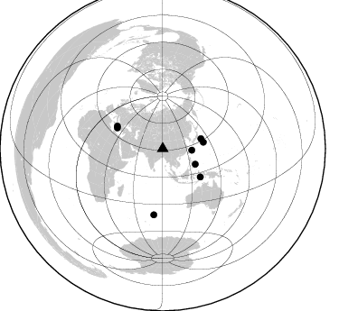
Nearby stations (2 deg radius)
| Station | Name | (Lat, Lon) | Start / End | Elevation |
| LUMP | Lumpola | (31.90, 89.93) | 1997-07-11 / 1999-12-31 | 4619 m |
| Crust2 Type: | R5,orogen/75km Tibet, 0 km seds. |
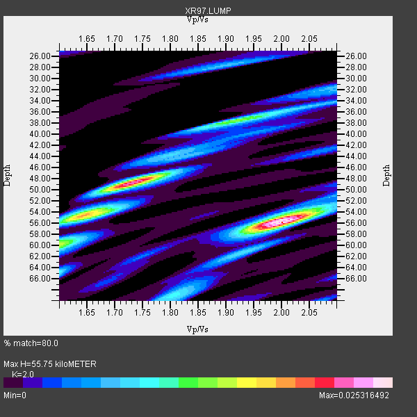
| Thickness Estimate: | 56 km |
| Thickness StdDev: | 8.1 km |
| Vp/Vs Estimate: | 2.00 |
| Vp/Vs StdDev: | 0.14 |
| Vs Estimate: | 3.25 km/s |
| Poisson's Ratio: | 0.33 |
| Peak Value: | 0.03 |
| Assumed Vp: | 6.5 km/s |
| Ps Weight: | 0.33333334 |
| PpPs Weight: | 0.33333334 |
| PsPs Weight: | 0.33333328 |
| Residual Complexity: | 0.752 |
| Nearby stations H: | +- |
| (2.0 deg) Vp/Vs: | +- |
3 with match > 90% ( 37.5 %) and 8 with match > 80% ( 100.0 %) out of 8.
Download stack as xyz text file.
Azimuth Distribution of Events:
Prior Results for this Station
| Study | Thickness | Vp/Vs | Vp | Vs | Poissons Ratio | Extra |
| EARS | 56 km | 2.00 | 6.5 km/s | 3.25 km/s | 0.33 | |
| Crust2.0 | 75 km | 1.76 | 6.5 km/s | 3.7 km/s | 0.26 | R5,orogen/75km Tibet, 0 km seds. |
| Global Maxima | 56 km | 2.00 | 6.5 km/s | 3.25 km/s | 0.33 | amp=0.025316492 |
| Local Maxima 1 | 48 km | 1.74 | 6.5 km/s | 3.746 km/s | 0.25 | amp=0.022664847 |
| Local Maxima 2 | 55 km | 1.63 | 6.5 km/s | 3.976 km/s | 0.20 | amp=0.01544079 |
| Local Maxima 3 | 38 km | 1.91 | 6.5 km/s | 3.408 km/s | 0.31 | amp=0.012828953 |
| Local Maxima 4 | 55 km | 1.99 | 6.5 km/s | 3.266 km/s | 0.33 | amp=0.009659349 |
| Predicted Arrivals for vertical incidence (zero ray parameter) | |
| Ps | 8.58 SECOND |
| PpPs | 25.73 SECOND |
| PsPs/PpSs | 34.31 SECOND |
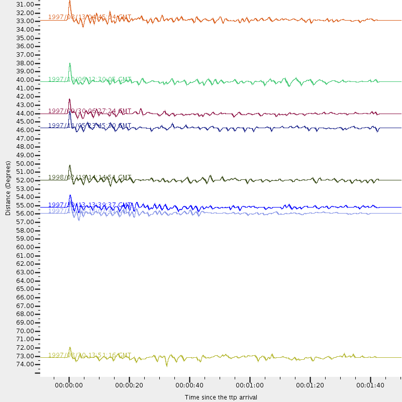
Events Processed for this Station
Download zip of receiver functions as SAC
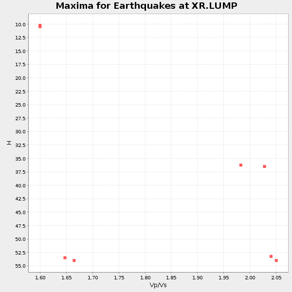
Plot maxima for each earthquake.
Events Used in the Stack
(8 events)| Radial Match | Distance | Baz | FERegion | Time | Lat/Lon | Depth | Magnitude |
| 92.76998 | 55.3 deg | 294.608 deg | Southern Greece | 1997/10/13 13:39:37 GMT | (36.4, 22.1) | 24 km | 6.2 MB, 6.6 MS, 6.7 UNKNOWN, 6.5 MW |
| 91.57647 | 56.1 deg | 296.379 deg | Ionian Sea | 1997/11/18 13:07:41 GMT | (37.6, 20.7) | 33 km | 5.9 MB, 6.4 MS, 6.7 UNKNOWN, 6.1 ML |
| 91.04924 | 51.9 deg | 126.895 deg | Banda Sea | 1998/02/19 14:14:51 GMT | (-4.5, 129.1) | 33 km | 6.1 MB, 6.4 MS, 6.5 UNKNOWN, 6.5 MW |
| 89.10411 | 39.8 deg | 115.592 deg | Mindanao, Philippines | 1997/10/06 12:30:05 GMT | (9.8, 125.8) | 106 km | 5.9 MB, 6.5 UNKNOWN, 6.4 MW |
| 88.62788 | 43.7 deg | 75.548 deg | Southeast Of Honshu, Japan | 1997/09/30 06:27:24 GMT | (32.0, 141.9) | 10 km | 5.5 MB, 6.5 MS, 6.1 UNKNOWN, 6.0 MW |
| 83.85673 | 73.8 deg | 187.624 deg | Mid-Indian Ridge | 1997/08/20 13:51:16 GMT | (-41.7, 80.1) | 10 km | 5.6 MB, 6.4 MS, 6.5 UNKNOWN, 6.4 MW |
| 83.24966 | 32.1 deg | 93.109 deg | Southwestern Ryukyu Isl., Japan | 1997/08/13 04:45:04 GMT | (25.0, 125.8) | 55 km | 6.0 MB, 5.6 MS, 6.1 UNKNOWN, 6.1 MW |
| 82.50511 | 45.5 deg | 80.869 deg | Bonin Islands, Japan Region | 1997/11/05 23:45:30 GMT | (27.9, 142.6) | 10 km | 5.4 MB, 5.6 MS, 6.0 UNKNOWN, 5.9 MW |
Losers
(0 events)| Radial Match | Distance | Baz | FERegion | Time | Lat/Lon | Depth | Magnitude | Reason |
