
Station XS N04 - XS.N04
Network: XS99 - Montana BB Array
Nearby stations (2 deg radius)

| Station | Name | (Lat, Lon) | Start / End | Elevation |
| N04 | XS.N04 | (46.21, -108.54) | 1999-08-21 / 2000-08-25 | 1800 m |
| Crust2 Type: | H6,early/mid Proter., U.S., 1.5 km seds. |
| Thickness Estimate: | 38 km |
| Thickness StdDev: | 7.5 km |
| Vp/Vs Estimate: | 2.03 |
| Vp/Vs StdDev: | 0.19 |
| Vs Estimate: | 3.219 km/s |
| Poisson's Ratio: | 0.34 |
| Peak Value: | 0.02 |
| Assumed Vp: | 6.518 km/s |
| Ps Weight: | 0.33333334 |
| PpPs Weight: | 0.33333334 |
| PsPs Weight: | 0.33333328 |
| Residual Complexity: | 0.755 |
| Nearby stations H: | +- |
| (2.0 deg) Vp/Vs: | +- |
4 with match > 90% ( 33.333332 %) and 12 with match > 80% ( 100.0 %) out of 12.
Download stack as xyz text file.
Azimuth Distribution of Events:

Prior Results for this Station
| Study | Thickness | Vp/Vs | Vp | Vs | Poissons Ratio | Extra |
| EARS | 38 km | 2.03 | 6.518 km/s | 3.219 km/s | 0.34 | |
| Crust2.0 | 52 km | 1.78 | 6.518 km/s | 3.665 km/s | 0.27 | H6,early/mid Proter., U.S., 1.5 km seds. |
| Global Maxima | 38 km | 2.03 | 6.518 km/s | 3.219 km/s | 0.34 | amp=0.015265939 |
| Local Maxima 1 | 54 km | 1.60 | 6.518 km/s | 4.074 km/s | 0.18 | amp=0.014700746 |
| Local Maxima 2 | 28 km | 2.10 | 6.518 km/s | 3.111 km/s | 0.35 | amp=0.011843098 |
| Local Maxima 3 | 41 km | 1.74 | 6.518 km/s | 3.741 km/s | 0.25 | amp=0.009957213 |
| Local Maxima 4 | 50 km | 1.75 | 6.518 km/s | 3.725 km/s | 0.26 | amp=0.009423058 |
| Predicted Arrivals for vertical incidence (zero ray parameter) | |
| Ps | 5.98 SECOND |
| PpPs | 17.63 SECOND |
| PsPs/PpSs | 23.61 SECOND |
Events Processed for this Station
Download zip of receiver functions as SAC
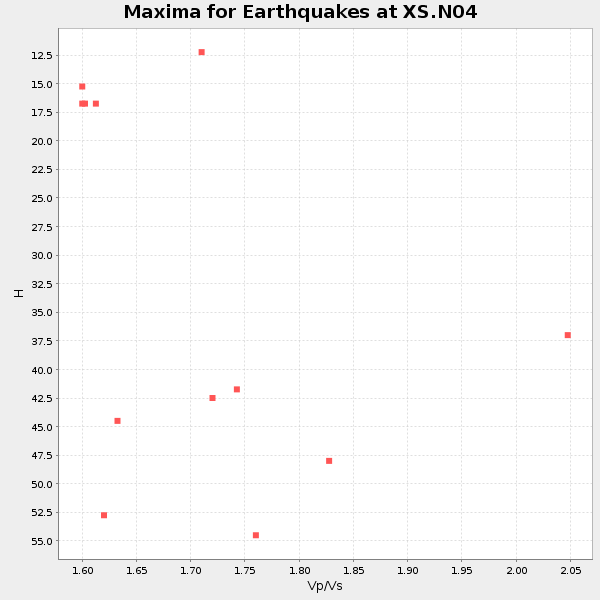
Plot maxima for each earthquake.
Events Used in the Stack
(12 events)| Radial Match | Distance | Baz | FERegion | Time | Lat/Lon | Depth | Magnitude |
| 96.55951 | 67.1 deg | 317.33 deg | Sakhalin, Russia | 2000/08/04 21:13:02 GMT | (48.8, 142.2) | 10 km | 6.3 MB, 7.1 MS, 6.8 MW, 6.7 MW |
| 95.75647 | 79.2 deg | 141.232 deg | Jujuy Province, Argentina | 2000/05/12 18:43:18 GMT | (-23.5, -66.5) | 225 km | 6.2 MB, 7.2 MW, 7.1 MW |
| 90.692474 | 79.5 deg | 308.386 deg | Southeast Of Honshu, Japan | 2000/07/30 12:25:45 GMT | (33.9, 139.4) | 10 km | 6.0 MB, 6.5 MS, 6.5 MW, 6.5 MW |
| 90.25139 | 41.7 deg | 144.22 deg | Off Coast Of Costa Rica | 2000/07/21 01:53:35 GMT | (9.4, -85.3) | 33 km | 5.9 MB, 6.1 MS, 6.4 MW, 5.7 ML |
| 89.65108 | 86.9 deg | 148.795 deg | Chile-Argentina Border Region | 2000/06/16 07:55:35 GMT | (-33.9, -70.1) | 120 km | 6.2 MB, 6.5 MW, 6.1 MD |
| 89.30632 | 48.9 deg | 35.804 deg | Iceland | 2000/06/21 00:51:46 GMT | (64.0, -20.8) | 10 km | 6.1 MB, 6.6 MS, 6.5 MW, 6.4 MW |
| 88.977806 | 33.9 deg | 151.317 deg | Near Coast Of Chiapas, Mexico | 2000/03/12 22:21:30 GMT | (15.0, -92.4) | 62 km | 5.5 MB, 5.8 MS, 6.3 MW, 5.4 MD |
| 88.86035 | 83.2 deg | 304.953 deg | Bonin Islands, Japan Region | 2000/08/06 07:27:12 GMT | (28.9, 139.6) | 395 km | 6.3 MB, 7.3 MW, 7.3 MW |
| 87.47793 | 49.0 deg | 35.759 deg | Iceland | 2000/06/17 15:40:41 GMT | (64.0, -20.5) | 10 km | 5.7 MB, 6.6 MS, 6.8 MW, 6.5 MW |
| 85.40527 | 76.7 deg | 309.138 deg | Near East Coast Of Honshu, Japan | 2000/07/20 18:39:18 GMT | (36.5, 141.0) | 47 km | 6.1 MB, 5.4 MS, 6.1 ME, 6.0 MW |
| 83.447426 | 44.7 deg | 135.491 deg | Panama | 2000/02/26 18:24:39 GMT | (9.4, -78.5) | 65 km | 5.8 MB, 5.4 MS, 6.2 MW, 6.1 MW |
| 81.40781 | 86.3 deg | 240.967 deg | Tonga Islands | 2000/01/08 16:47:20 GMT | (-16.9, -174.2) | 183 km | 6.5 MB, 6.6 MS, 7.2 MW, 7.0 ME |
Losers
(0 events)| Radial Match | Distance | Baz | FERegion | Time | Lat/Lon | Depth | Magnitude | Reason |
