
Station XS N10 - XS.N10
Network: XS99 - Montana BB Array
Nearby stations (2 deg radius)
| Station | Name | (Lat, Lon) | Start / End | Elevation |
| N10 | XS.N10 | (46.61, -109.19) | 1999-08-21 / 2000-08-25 | 1800 m |
| Crust2 Type: | H6,early/mid Proter., U.S., 1.5 km seds. |
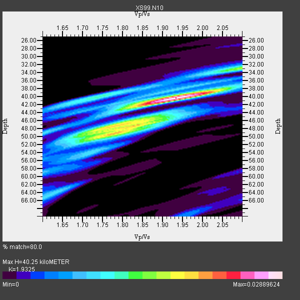
| Thickness Estimate: | 40 km |
| Thickness StdDev: | 4.0 km |
| Vp/Vs Estimate: | 1.93 |
| Vp/Vs StdDev: | 0.09 |
| Vs Estimate: | 3.373 km/s |
| Poisson's Ratio: | 0.32 |
| Peak Value: | 0.03 |
| Assumed Vp: | 6.518 km/s |
| Ps Weight: | 0.33333334 |
| PpPs Weight: | 0.33333334 |
| PsPs Weight: | 0.33333328 |
| Residual Complexity: | 0.662 |
| Nearby stations H: | +- |
| (2.0 deg) Vp/Vs: | +- |
5 with match > 90% ( 50.0 %) and 10 with match > 80% ( 100.0 %) out of 10.
Download stack as xyz text file.
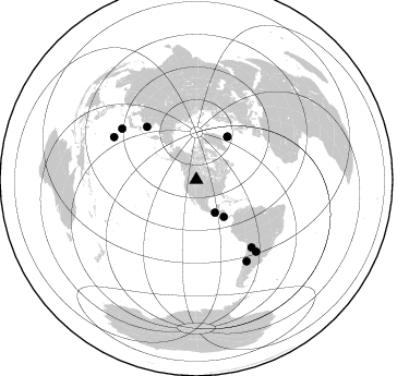
Azimuth Distribution of Events:
Prior Results for this Station
| Study | Thickness | Vp/Vs | Vp | Vs | Poissons Ratio | Extra |
| EARS | 40 km | 1.93 | 6.518 km/s | 3.373 km/s | 0.32 | |
| Crust2.0 | 52 km | 1.78 | 6.518 km/s | 3.665 km/s | 0.27 | H6,early/mid Proter., U.S., 1.5 km seds. |
| Global Maxima | 40 km | 1.93 | 6.518 km/s | 3.373 km/s | 0.32 | amp=0.02889624 |
| Local Maxima 1 | 48 km | 1.75 | 6.518 km/s | 3.735 km/s | 0.26 | amp=0.016918452 |
| Local Maxima 2 | 49 km | 1.80 | 6.518 km/s | 3.631 km/s | 0.27 | amp=0.013760942 |
| Local Maxima 3 | 40 km | 1.75 | 6.518 km/s | 3.73 km/s | 0.26 | amp=0.012786241 |
| Local Maxima 4 | 33 km | 2.10 | 6.518 km/s | 3.108 km/s | 0.35 | amp=0.010380863 |
| Predicted Arrivals for vertical incidence (zero ray parameter) | |
| Ps | 5.76 SECOND |
| PpPs | 18.11 SECOND |
| PsPs/PpSs | 23.87 SECOND |
Events Processed for this Station
Download zip of receiver functions as SAC
Plot maxima for each earthquake.
Events Used in the Stack
(10 events)| Radial Match | Distance | Baz | FERegion | Time | Lat/Lon | Depth | Magnitude |
| 96.52432 | 85.0 deg | 297.334 deg | Volcano Islands, Japan Region | 2000/03/28 11:00:22 GMT | (22.3, 143.7) | 126 km | 6.8 MB, 7.6 MS, 7.6 MW, 7.6 MW |
| 94.51734 | 66.5 deg | 316.883 deg | Sakhalin, Russia | 2000/08/04 21:13:02 GMT | (48.8, 142.2) | 10 km | 6.3 MB, 7.1 MS, 6.8 MW, 6.7 MW |
| 93.65976 | 79.8 deg | 140.742 deg | Jujuy Province, Argentina | 2000/05/12 18:43:18 GMT | (-23.5, -66.5) | 225 km | 6.2 MB, 7.2 MW, 7.1 MW |
| 91.13418 | 42.3 deg | 143.607 deg | Off Coast Of Costa Rica | 2000/07/21 01:53:35 GMT | (9.4, -85.3) | 33 km | 5.9 MB, 6.1 MS, 6.4 MW, 5.7 ML |
| 90.98403 | 82.6 deg | 304.473 deg | Bonin Islands, Japan Region | 2000/08/06 07:27:12 GMT | (28.9, 139.6) | 395 km | 6.3 MB, 7.3 MW, 7.3 MW |
| 89.19082 | 48.8 deg | 35.859 deg | Iceland | 2000/06/21 00:51:46 GMT | (64.0, -20.8) | 10 km | 6.1 MB, 6.6 MS, 6.5 MW, 6.4 MW |
| 88.92566 | 34.5 deg | 150.554 deg | Near Coast Of Chiapas, Mexico | 2000/03/12 22:21:30 GMT | (15.0, -92.4) | 62 km | 5.5 MB, 5.8 MS, 6.3 MW, 5.4 MD |
| 83.76189 | 48.9 deg | 35.812 deg | Iceland | 2000/06/17 15:40:41 GMT | (64.0, -20.5) | 10 km | 5.7 MB, 6.6 MS, 6.8 MW, 6.5 MW |
| 83.294945 | 87.5 deg | 148.315 deg | Chile-Argentina Border Region | 2000/06/16 07:55:35 GMT | (-33.9, -70.1) | 120 km | 6.2 MB, 6.5 MW, 6.1 MD |
| 80.35865 | 85.5 deg | 140.325 deg | Santiago Del Estero Prov., Arg. | 2000/04/23 09:27:23 GMT | (-28.3, -63.0) | 608 km | 6.6 MB, 7.0 MW, 7.0 MW |
Losers
(0 events)| Radial Match | Distance | Baz | FERegion | Time | Lat/Lon | Depth | Magnitude | Reason |
