
Station XS N11 - XS.N11
Network: XS99 - Montana BB Array
Nearby stations (2 deg radius)
| Station | Name | (Lat, Lon) | Start / End | Elevation |
| N11 | XS.N11 | (46.67, -108.89) | 1999-08-21 / 2000-08-25 | 1800 m |
| Crust2 Type: | H6,early/mid Proter., U.S., 1.5 km seds. |
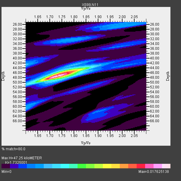
| Thickness Estimate: | 47 km |
| Thickness StdDev: | 3.9 km |
| Vp/Vs Estimate: | 1.73 |
| Vp/Vs StdDev: | 0.05 |
| Vs Estimate: | 3.762 km/s |
| Poisson's Ratio: | 0.25 |
| Peak Value: | 0.02 |
| Assumed Vp: | 6.518 km/s |
| Ps Weight: | 0.33333334 |
| PpPs Weight: | 0.33333334 |
| PsPs Weight: | 0.33333328 |
| Residual Complexity: | 0.512 |
| Nearby stations H: | +- |
| (2.0 deg) Vp/Vs: | +- |
10 with match > 90% ( 55.555557 %) and 18 with match > 80% ( 100.0 %) out of 18.
Download stack as xyz text file.
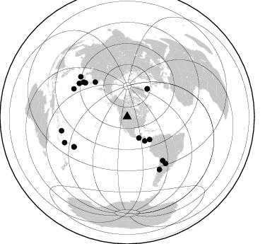
Azimuth Distribution of Events:
Prior Results for this Station
| Study | Thickness | Vp/Vs | Vp | Vs | Poissons Ratio | Extra |
| EARS | 47 km | 1.73 | 6.518 km/s | 3.762 km/s | 0.25 | |
| Crust2.0 | 52 km | 1.78 | 6.518 km/s | 3.665 km/s | 0.27 | H6,early/mid Proter., U.S., 1.5 km seds. |
| Global Maxima | 47 km | 1.73 | 6.518 km/s | 3.762 km/s | 0.25 | amp=0.017625138 |
| Local Maxima 1 | 45 km | 1.79 | 6.518 km/s | 3.647 km/s | 0.27 | amp=0.008336214 |
| Local Maxima 2 | 42 km | 1.60 | 6.518 km/s | 4.074 km/s | 0.18 | amp=0.004907591 |
| Local Maxima 3 | 27 km | 1.99 | 6.518 km/s | 3.276 km/s | 0.33 | amp=0.0044002957 |
| Local Maxima 4 | 60 km | 1.60 | 6.518 km/s | 4.074 km/s | 0.18 | amp=0.004006468 |
| Predicted Arrivals for vertical incidence (zero ray parameter) | |
| Ps | 5.31 SECOND |
| PpPs | 19.81 SECOND |
| PsPs/PpSs | 25.12 SECOND |
Events Processed for this Station
Download zip of receiver functions as SAC
Plot maxima for each earthquake.
Events Used in the Stack
(18 events)| Radial Match | Distance | Baz | FERegion | Time | Lat/Lon | Depth | Magnitude |
| 96.840034 | 48.6 deg | 35.964 deg | Iceland | 2000/06/21 00:51:46 GMT | (64.0, -20.8) | 10 km | 6.1 MB, 6.6 MS, 6.5 MW, 6.4 MW |
| 96.1571 | 85.2 deg | 297.544 deg | Volcano Islands, Japan Region | 2000/03/28 11:00:22 GMT | (22.3, 143.7) | 126 km | 6.8 MB, 7.6 MS, 7.6 MW, 7.6 MW |
| 95.71497 | 66.6 deg | 317.02 deg | Sakhalin, Russia | 2000/08/04 21:13:02 GMT | (48.8, 142.2) | 10 km | 6.3 MB, 7.1 MS, 6.8 MW, 6.7 MW |
| 94.49724 | 79.7 deg | 141.002 deg | Jujuy Province, Argentina | 2000/05/12 18:43:18 GMT | (-23.5, -66.5) | 225 km | 6.2 MB, 7.2 MW, 7.1 MW |
| 93.7759 | 48.8 deg | 35.917 deg | Iceland | 2000/06/17 15:40:41 GMT | (64.0, -20.5) | 10 km | 5.7 MB, 6.6 MS, 6.8 MW, 6.5 MW |
| 93.43992 | 82.8 deg | 304.674 deg | Bonin Islands, Japan Region | 2000/08/06 07:27:12 GMT | (28.9, 139.6) | 395 km | 6.3 MB, 7.3 MW, 7.3 MW |
| 93.14888 | 42.2 deg | 144.06 deg | Off Coast Of Costa Rica | 2000/07/21 01:53:35 GMT | (9.4, -85.3) | 33 km | 5.9 MB, 6.1 MS, 6.4 MW, 5.7 ML |
| 92.55246 | 86.3 deg | 240.684 deg | Tonga Islands | 2000/01/08 16:47:20 GMT | (-16.9, -174.2) | 183 km | 6.5 MB, 6.6 MS, 7.2 MW, 7.0 ME |
| 91.09282 | 34.5 deg | 151.092 deg | Near Coast Of Chiapas, Mexico | 2000/03/12 22:21:30 GMT | (15.0, -92.4) | 62 km | 5.5 MB, 5.8 MS, 6.3 MW, 5.4 MD |
| 90.07817 | 87.5 deg | 148.548 deg | Chile-Argentina Border Region | 2000/06/16 07:55:35 GMT | (-33.9, -70.1) | 120 km | 6.2 MB, 6.5 MW, 6.1 MD |
| 88.3291 | 79.0 deg | 308.096 deg | Southeast Of Honshu, Japan | 2000/07/30 12:25:45 GMT | (33.9, 139.4) | 10 km | 6.0 MB, 6.5 MS, 6.5 MW, 6.5 MW |
| 88.17691 | 85.4 deg | 140.564 deg | Santiago Del Estero Prov., Arg. | 2000/04/23 09:27:23 GMT | (-28.3, -63.0) | 608 km | 6.6 MB, 7.0 MW, 7.0 MW |
| 87.203926 | 45.2 deg | 135.4 deg | Panama | 2000/02/26 18:24:39 GMT | (9.4, -78.5) | 65 km | 5.8 MB, 5.4 MS, 6.2 MW, 6.1 MW |
| 85.45388 | 95.0 deg | 257.911 deg | Santa Cruz Islands | 2000/08/03 01:09:38 GMT | (-12.0, 166.4) | 33 km | 5.7 MB, 6.5 MS, 6.7 MW, 6.6 MW |
| 83.55948 | 86.7 deg | 310.617 deg | Southeast Of Ryukyu Islands | 2000/06/06 14:57:02 GMT | (29.4, 131.4) | 33 km | 5.8 MB, 6.0 MS, 6.4 MW, 6.4 MW |
| 81.6134 | 95.6 deg | 247.602 deg | Vanuatu Islands Region | 2000/02/25 01:43:58 GMT | (-19.5, 173.8) | 33 km | 6.1 MB, 7.1 MS, 7.1 MW, 7.0 MW |
| 81.00243 | 86.4 deg | 240.283 deg | Tonga Islands | 2000/01/26 13:26:50 GMT | (-17.3, -174.0) | 33 km | 5.9 MB, 6.0 MS, 6.4 MW, 6.3 MW |
| 80.77797 | 76.2 deg | 308.837 deg | Near East Coast Of Honshu, Japan | 2000/07/20 18:39:18 GMT | (36.5, 141.0) | 47 km | 6.1 MB, 5.4 MS, 6.1 ME, 6.0 MW |
Losers
(0 events)| Radial Match | Distance | Baz | FERegion | Time | Lat/Lon | Depth | Magnitude | Reason |
