
Station XS S02 - XS.S02
Network: XS99 - Montana BB Array
Nearby stations (2 deg radius)

| Station | Name | (Lat, Lon) | Start / End | Elevation |
| S02 | XS.S02 | (45.27, -108.77) | 1999-08-21 / 2000-08-25 | 1800 m |
| Crust2 Type: | PD,orogen/50km, Tibet, 2 km seds. |
| Thickness Estimate: | 54 km |
| Thickness StdDev: | 11 km |
| Vp/Vs Estimate: | 1.74 |
| Vp/Vs StdDev: | 0.12 |
| Vs Estimate: | 3.582 km/s |
| Poisson's Ratio: | 0.25 |
| Peak Value: | 0.02 |
| Assumed Vp: | 6.242 km/s |
| Ps Weight: | 0.33333334 |
| PpPs Weight: | 0.33333334 |
| PsPs Weight: | 0.33333328 |
| Residual Complexity: | 0.802 |
| Nearby stations H: | +- |
| (2.0 deg) Vp/Vs: | +- |
8 with match > 90% ( 42.105263 %) and 19 with match > 80% ( 100.0 %) out of 19.
Download stack as xyz text file.
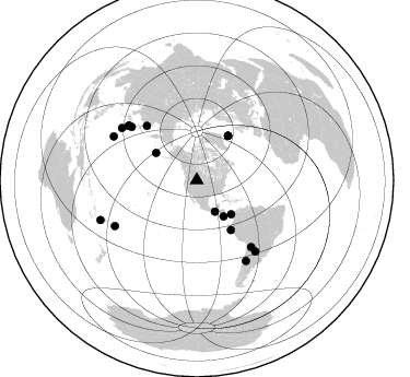
Azimuth Distribution of Events:
Prior Results for this Station
| Study | Thickness | Vp/Vs | Vp | Vs | Poissons Ratio | Extra |
| EARS | 54 km | 1.74 | 6.242 km/s | 3.582 km/s | 0.25 | |
| Crust2.0 | 50 km | 1.76 | 6.242 km/s | 3.546 km/s | 0.26 | PD,orogen/50km, Tibet, 2 km seds. |
| Global Maxima | 54 km | 1.74 | 6.242 km/s | 3.582 km/s | 0.25 | amp=0.015251664 |
| Local Maxima 1 | 69 km | 1.61 | 6.242 km/s | 3.871 km/s | 0.19 | amp=0.012481947 |
| Local Maxima 2 | 34 km | 1.66 | 6.242 km/s | 3.766 km/s | 0.21 | amp=0.010740901 |
| Local Maxima 3 | 38 km | 2.01 | 6.242 km/s | 3.105 km/s | 0.34 | amp=0.009616091 |
| Local Maxima 4 | 46 km | 1.92 | 6.242 km/s | 3.251 km/s | 0.31 | amp=0.0076812697 |
| Predicted Arrivals for vertical incidence (zero ray parameter) | |
| Ps | 6.45 SECOND |
| PpPs | 23.84 SECOND |
| PsPs/PpSs | 30.29 SECOND |
Events Processed for this Station
Download zip of receiver functions as SAC
Plot maxima for each earthquake.
Events Used in the Stack
(19 events)| Radial Match | Distance | Baz | FERegion | Time | Lat/Lon | Depth | Magnitude |
| 97.0419 | 85.9 deg | 297.721 deg | Volcano Islands, Japan Region | 2000/03/28 11:00:22 GMT | (22.3, 143.7) | 126 km | 6.8 MB, 7.6 MS, 7.6 MW, 7.6 MW |
| 95.57405 | 78.6 deg | 140.928 deg | Jujuy Province, Argentina | 2000/05/12 18:43:18 GMT | (-23.5, -66.5) | 225 km | 6.2 MB, 7.2 MW, 7.1 MW |
| 95.349464 | 67.7 deg | 317.479 deg | Sakhalin, Russia | 2000/08/04 21:13:02 GMT | (48.8, 142.2) | 10 km | 6.3 MB, 7.1 MS, 6.8 MW, 6.7 MW |
| 93.2916 | 41.0 deg | 143.28 deg | Off Coast Of Costa Rica | 2000/07/21 01:53:35 GMT | (9.4, -85.3) | 33 km | 5.9 MB, 6.1 MS, 6.4 MW, 5.7 ML |
| 92.675354 | 49.7 deg | 35.284 deg | Iceland | 2000/06/21 00:51:46 GMT | (64.0, -20.8) | 10 km | 6.1 MB, 6.6 MS, 6.5 MW, 6.4 MW |
| 92.6684 | 86.2 deg | 148.594 deg | Chile-Argentina Border Region | 2000/06/16 07:55:35 GMT | (-33.9, -70.1) | 120 km | 6.2 MB, 6.5 MW, 6.1 MD |
| 91.866844 | 44.9 deg | 303.943 deg | Andreanof Islands, Aleutian Is. | 2000/04/21 04:35:17 GMT | (51.4, -178.1) | 33 km | 6.0 MB, 5.7 MS, 6.2 ML, 6.0 MW |
| 91.33529 | 83.6 deg | 304.889 deg | Bonin Islands, Japan Region | 2000/08/06 07:27:12 GMT | (28.9, 139.6) | 395 km | 6.3 MB, 7.3 MW, 7.3 MW |
| 89.82296 | 84.2 deg | 140.572 deg | Santiago Del Estero Prov., Arg. | 2000/04/23 09:27:23 GMT | (-28.3, -63.0) | 608 km | 6.6 MB, 7.0 MW, 7.0 MW |
| 89.464226 | 80.0 deg | 308.374 deg | Southeast Of Honshu, Japan | 2000/07/30 12:25:45 GMT | (33.9, 139.4) | 10 km | 6.0 MB, 6.5 MS, 6.5 MW, 6.5 MW |
| 88.79002 | 77.1 deg | 309.167 deg | Near East Coast Of Honshu, Japan | 2000/07/20 18:39:18 GMT | (36.5, 141.0) | 47 km | 6.1 MB, 5.4 MS, 6.1 ME, 6.0 MW |
| 88.696884 | 33.2 deg | 150.254 deg | Near Coast Of Chiapas, Mexico | 2000/03/12 22:21:30 GMT | (15.0, -92.4) | 62 km | 5.5 MB, 5.8 MS, 6.3 MW, 5.4 MD |
| 87.89083 | 49.9 deg | 35.241 deg | Iceland | 2000/06/17 15:40:41 GMT | (64.0, -20.5) | 10 km | 5.7 MB, 6.6 MS, 6.8 MW, 6.5 MW |
| 87.39362 | 85.7 deg | 240.856 deg | Tonga Islands | 2000/01/08 16:47:20 GMT | (-16.9, -174.2) | 183 km | 6.5 MB, 6.6 MS, 7.2 MW, 7.0 ME |
| 86.1357 | 79.9 deg | 308.744 deg | Near S. Coast Of Honshu, Japan | 2000/07/01 07:01:55 GMT | (34.2, 139.1) | 10 km | 6.0 MB, 6.1 MS, 6.2 MW, 6.2 MW |
| 85.86868 | 49.8 deg | 35.275 deg | Iceland | 2000/06/17 15:42:52 GMT | (64.0, -20.6) | 10 km | 5.7 MB |
| 82.80757 | 44.2 deg | 134.537 deg | Panama | 2000/02/26 18:24:39 GMT | (9.4, -78.5) | 65 km | 5.8 MB, 5.4 MS, 6.2 MW, 6.1 MW |
| 81.1735 | 95.2 deg | 247.559 deg | Vanuatu Islands Region | 2000/02/25 01:43:58 GMT | (-19.5, 173.8) | 33 km | 6.1 MB, 7.1 MS, 7.1 MW, 7.0 MW |
| 80.21477 | 55.0 deg | 145.561 deg | Near Coast Of Northern Peru | 2000/05/22 13:15:08 GMT | (-4.1, -81.1) | 33 km | 5.3 MB, 5.4 MS, 5.8 MW, 5.8 MW |
Losers
(0 events)| Radial Match | Distance | Baz | FERegion | Time | Lat/Lon | Depth | Magnitude | Reason |
