
Station XS S06 - XS.S06
Network: XS99 - Montana BB Array
Nearby stations (2 deg radius)
| Station | Name | (Lat, Lon) | Start / End | Elevation |
| S06 | XS.S06 | (45.58, -108.61) | 1999-08-21 / 2000-08-25 | 1800 m |
| Crust2 Type: | PD,orogen/50km, Tibet, 2 km seds. |
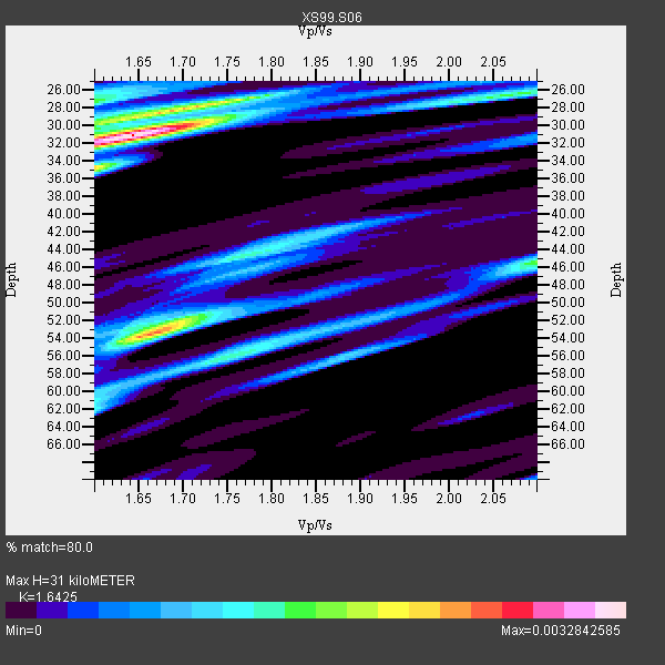
| Thickness Estimate: | 31 km |
| Thickness StdDev: | 12 km |
| Vp/Vs Estimate: | 1.64 |
| Vp/Vs StdDev: | 0.11 |
| Vs Estimate: | 3.8 km/s |
| Poisson's Ratio: | 0.21 |
| Peak Value: | 0.00 |
| Assumed Vp: | 6.242 km/s |
| Ps Weight: | 0.33333334 |
| PpPs Weight: | 0.33333334 |
| PsPs Weight: | 0.33333328 |
| Residual Complexity: | 0.737 |
| Nearby stations H: | 28 km +- 3.5 km |
| (2.0 deg) Vp/Vs: | 1.66 +- 0.04 |
8 with match > 90% ( 53.333332 %) and 15 with match > 80% ( 100.0 %) out of 15.
Download stack as xyz text file.
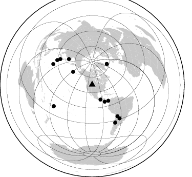
Azimuth Distribution of Events:
Prior Results for this Station
| Study | Thickness | Vp/Vs | Vp | Vs | Poissons Ratio | Extra |
| EARS | 31 km | 1.64 | 6.242 km/s | 3.8 km/s | 0.21 | |
| Crust2.0 | 50 km | 1.76 | 6.242 km/s | 3.546 km/s | 0.26 | PD,orogen/50km, Tibet, 2 km seds. |
| Global Maxima | 31 km | 1.64 | 6.242 km/s | 3.8 km/s | 0.21 | amp=0.0032842585 |
| Local Maxima 1 | 53 km | 1.67 | 6.242 km/s | 3.732 km/s | 0.22 | amp=0.0026074036 |
| Local Maxima 2 | 28 km | 1.72 | 6.242 km/s | 3.64 km/s | 0.24 | amp=0.00189544 |
| Local Maxima 3 | 27 km | 1.60 | 6.242 km/s | 3.901 km/s | 0.18 | amp=0.0015087477 |
| Local Maxima 4 | 56 km | 1.75 | 6.242 km/s | 3.567 km/s | 0.26 | amp=0.0014351589 |
| Predicted Arrivals for vertical incidence (zero ray parameter) | |
| Ps | 3.19 SECOND |
| PpPs | 13.12 SECOND |
| PsPs/PpSs | 16.31 SECOND |
Events Processed for this Station
Download zip of receiver functions as SAC
Plot maxima for each earthquake.
Events Used in the Stack
(15 events)| Radial Match | Distance | Baz | FERegion | Time | Lat/Lon | Depth | Magnitude |
| 97.8294 | 78.8 deg | 141.099 deg | Jujuy Province, Argentina | 2000/05/12 18:43:18 GMT | (-23.5, -66.5) | 225 km | 6.2 MB, 7.2 MW, 7.1 MW |
| 97.43135 | 85.9 deg | 297.812 deg | Volcano Islands, Japan Region | 2000/03/28 11:00:22 GMT | (22.3, 143.7) | 126 km | 6.8 MB, 7.6 MS, 7.6 MW, 7.6 MW |
| 95.56692 | 67.6 deg | 317.473 deg | Sakhalin, Russia | 2000/08/04 21:13:02 GMT | (48.8, 142.2) | 10 km | 6.3 MB, 7.1 MS, 6.8 MW, 6.7 MW |
| 93.68538 | 84.4 deg | 140.715 deg | Santiago Del Estero Prov., Arg. | 2000/04/23 09:27:23 GMT | (-28.3, -63.0) | 608 km | 6.6 MB, 7.0 MW, 7.0 MW |
| 93.17144 | 83.5 deg | 304.968 deg | Bonin Islands, Japan Region | 2000/08/06 07:27:12 GMT | (28.9, 139.6) | 395 km | 6.3 MB, 7.3 MW, 7.3 MW |
| 92.871506 | 41.2 deg | 143.709 deg | Off Coast Of Costa Rica | 2000/07/21 01:53:35 GMT | (9.4, -85.3) | 33 km | 5.9 MB, 6.1 MS, 6.4 MW, 5.7 ML |
| 90.821014 | 49.4 deg | 35.472 deg | Iceland | 2000/06/21 00:51:46 GMT | (64.0, -20.8) | 10 km | 6.1 MB, 6.6 MS, 6.5 MW, 6.4 MW |
| 90.07186 | 33.4 deg | 150.75 deg | Near Coast Of Chiapas, Mexico | 2000/03/12 22:21:30 GMT | (15.0, -92.4) | 62 km | 5.5 MB, 5.8 MS, 6.3 MW, 5.4 MD |
| 89.51405 | 85.9 deg | 240.955 deg | Tonga Islands | 2000/01/08 16:47:20 GMT | (-16.9, -174.2) | 183 km | 6.5 MB, 6.6 MS, 7.2 MW, 7.0 ME |
| 89.49619 | 86.4 deg | 148.725 deg | Chile-Argentina Border Region | 2000/06/16 07:55:35 GMT | (-33.9, -70.1) | 120 km | 6.2 MB, 6.5 MW, 6.1 MD |
| 87.17921 | 49.5 deg | 35.429 deg | Iceland | 2000/06/17 15:40:41 GMT | (64.0, -20.5) | 10 km | 5.7 MB, 6.6 MS, 6.8 MW, 6.5 MW |
| 83.93287 | 44.3 deg | 134.959 deg | Panama | 2000/02/26 18:24:39 GMT | (9.4, -78.5) | 65 km | 5.8 MB, 5.4 MS, 6.2 MW, 6.1 MW |
| 81.69653 | 44.9 deg | 303.736 deg | Andreanof Islands, Aleutian Is. | 2000/04/21 04:35:17 GMT | (51.4, -178.1) | 33 km | 6.0 MB, 5.7 MS, 6.2 ML, 6.0 MW |
| 81.39321 | 79.9 deg | 308.433 deg | Southeast Of Honshu, Japan | 2000/07/30 12:25:45 GMT | (33.9, 139.4) | 10 km | 6.0 MB, 6.5 MS, 6.5 MW, 6.5 MW |
| 80.76689 | 86.0 deg | 240.552 deg | Tonga Islands | 2000/01/26 13:26:50 GMT | (-17.3, -174.0) | 33 km | 5.9 MB, 6.0 MS, 6.4 MW, 6.3 MW |
Losers
(0 events)| Radial Match | Distance | Baz | FERegion | Time | Lat/Lon | Depth | Magnitude | Reason |
