
Station XS S13 - XS.S13
Network: XS99 - Montana BB Array
Nearby stations (2 deg radius)
| Station | Name | (Lat, Lon) | Start / End | Elevation |
| S13 | XS.S13 | (45.74, -109.43) | 1999-08-21 / 2000-08-25 | 1800 m |
| Crust2 Type: | PD,orogen/50km, Tibet, 2 km seds. |
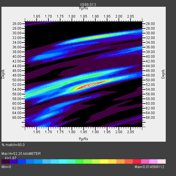
| Thickness Estimate: | 52 km |
| Thickness StdDev: | 9.3 km |
| Vp/Vs Estimate: | 1.87 |
| Vp/Vs StdDev: | 0.11 |
| Vs Estimate: | 3.338 km/s |
| Poisson's Ratio: | 0.30 |
| Peak Value: | 0.01 |
| Assumed Vp: | 6.242 km/s |
| Ps Weight: | 0.33333334 |
| PpPs Weight: | 0.33333334 |
| PsPs Weight: | 0.33333328 |
| Residual Complexity: | 0.711 |
| Nearby stations H: | +- |
| (2.0 deg) Vp/Vs: | +- |
3 with match > 90% ( 33.333332 %) and 9 with match > 80% ( 100.0 %) out of 9.
Download stack as xyz text file.
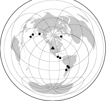
Azimuth Distribution of Events:
Prior Results for this Station
| Study | Thickness | Vp/Vs | Vp | Vs | Poissons Ratio | Extra |
| EARS | 52 km | 1.87 | 6.242 km/s | 3.338 km/s | 0.30 | |
| Crust2.0 | 50 km | 1.76 | 6.242 km/s | 3.546 km/s | 0.26 | PD,orogen/50km, Tibet, 2 km seds. |
| Global Maxima | 52 km | 1.87 | 6.242 km/s | 3.338 km/s | 0.30 | amp=0.014568112 |
| Local Maxima 1 | 32 km | 1.91 | 6.242 km/s | 3.272 km/s | 0.31 | amp=0.008886152 |
| Local Maxima 2 | 50 km | 1.79 | 6.242 km/s | 3.492 km/s | 0.27 | amp=0.008130093 |
| Local Maxima 3 | 54 km | 1.68 | 6.242 km/s | 3.727 km/s | 0.22 | amp=0.007157675 |
| Local Maxima 4 | 50 km | 1.96 | 6.242 km/s | 3.193 km/s | 0.32 | amp=0.004201659 |
| Predicted Arrivals for vertical incidence (zero ray parameter) | |
| Ps | 7.28 SECOND |
| PpPs | 24.02 SECOND |
| PsPs/PpSs | 31.31 SECOND |
Events Processed for this Station
Download zip of receiver functions as SAC
Plot maxima for each earthquake.
Events Used in the Stack
(9 events)| Radial Match | Distance | Baz | FERegion | Time | Lat/Lon | Depth | Magnitude |
| 95.21007 | 85.3 deg | 297.232 deg | Volcano Islands, Japan Region | 2000/03/28 11:00:22 GMT | (22.3, 143.7) | 126 km | 6.8 MB, 7.6 MS, 7.6 MW, 7.6 MW |
| 94.24541 | 67.1 deg | 317.015 deg | Sakhalin, Russia | 2000/08/04 21:13:02 GMT | (48.8, 142.2) | 10 km | 6.3 MB, 7.1 MS, 6.8 MW, 6.7 MW |
| 92.55467 | 79.3 deg | 140.444 deg | Jujuy Province, Argentina | 2000/05/12 18:43:18 GMT | (-23.5, -66.5) | 225 km | 6.2 MB, 7.2 MW, 7.1 MW |
| 87.938934 | 33.8 deg | 149.531 deg | Near Coast Of Chiapas, Mexico | 2000/03/12 22:21:30 GMT | (15.0, -92.4) | 62 km | 5.5 MB, 5.8 MS, 6.3 MW, 5.4 MD |
| 87.811226 | 41.7 deg | 142.709 deg | Off Coast Of Costa Rica | 2000/07/21 01:53:35 GMT | (9.4, -85.3) | 33 km | 5.9 MB, 6.1 MS, 6.4 MW, 5.7 ML |
| 87.29779 | 83.0 deg | 304.402 deg | Bonin Islands, Japan Region | 2000/08/06 07:27:12 GMT | (28.9, 139.6) | 395 km | 6.3 MB, 7.3 MW, 7.3 MW |
| 83.71992 | 49.6 deg | 35.369 deg | Iceland | 2000/06/21 00:51:46 GMT | (64.0, -20.8) | 10 km | 6.1 MB, 6.6 MS, 6.5 MW, 6.4 MW |
| 83.25542 | 84.9 deg | 140.094 deg | Santiago Del Estero Prov., Arg. | 2000/04/23 09:27:23 GMT | (-28.3, -63.0) | 608 km | 6.6 MB, 7.0 MW, 7.0 MW |
| 80.63964 | 86.9 deg | 148.113 deg | Chile-Argentina Border Region | 2000/06/16 07:55:35 GMT | (-33.9, -70.1) | 120 km | 6.2 MB, 6.5 MW, 6.1 MD |
Losers
(0 events)| Radial Match | Distance | Baz | FERegion | Time | Lat/Lon | Depth | Magnitude | Reason |
