
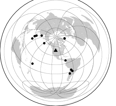
Station XS S20 - XS.S20
Network: XS99 - Montana BB Array
Nearby stations (2 deg radius)

| Station | Name | (Lat, Lon) | Start / End | Elevation |
| S20 | XS.S20 | (46.06, -108.94) | 1999-08-21 / 2000-08-25 | 1800 m |
| Crust2 Type: | H6,early/mid Proter., U.S., 1.5 km seds. |
| Thickness Estimate: | 51 km |
| Thickness StdDev: | 4.6 km |
| Vp/Vs Estimate: | 1.76 |
| Vp/Vs StdDev: | 0.09 |
| Vs Estimate: | 3.698 km/s |
| Poisson's Ratio: | 0.26 |
| Peak Value: | 0.01 |
| Assumed Vp: | 6.518 km/s |
| Ps Weight: | 0.33333334 |
| PpPs Weight: | 0.33333334 |
| PsPs Weight: | 0.33333328 |
| Residual Complexity: | 0.627 |
| Nearby stations H: | +- |
| (2.0 deg) Vp/Vs: | +- |
7 with match > 90% ( 58.333332 %) and 12 with match > 80% ( 100.0 %) out of 12.
Download stack as xyz text file.
Azimuth Distribution of Events:
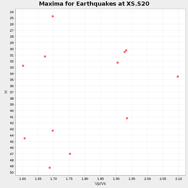
Prior Results for this Station
| Study | Thickness | Vp/Vs | Vp | Vs | Poissons Ratio | Extra |
| EARS | 51 km | 1.76 | 6.518 km/s | 3.698 km/s | 0.26 | |
| Crust2.0 | 52 km | 1.78 | 6.518 km/s | 3.665 km/s | 0.27 | H6,early/mid Proter., U.S., 1.5 km seds. |
| Global Maxima | 51 km | 1.76 | 6.518 km/s | 3.698 km/s | 0.26 | amp=0.013742765 |
| Local Maxima 1 | 50 km | 1.76 | 6.518 km/s | 3.709 km/s | 0.26 | amp=0.008968198 |
| Local Maxima 2 | 44 km | 1.67 | 6.518 km/s | 3.909 km/s | 0.22 | amp=0.007999783 |
| Local Maxima 3 | 34 km | 2.10 | 6.518 km/s | 3.111 km/s | 0.35 | amp=0.0041140504 |
| Local Maxima 4 | 32 km | 1.91 | 6.518 km/s | 3.404 km/s | 0.31 | amp=0.003536838 |
| Predicted Arrivals for vertical incidence (zero ray parameter) | |
| Ps | 5.97 SECOND |
| PpPs | 21.61 SECOND |
| PsPs/PpSs | 27.58 SECOND |
Events Processed for this Station
Download zip of receiver functions as SAC
Plot maxima for each earthquake.
Events Used in the Stack
(12 events)| Radial Match | Distance | Baz | FERegion | Time | Lat/Lon | Depth | Magnitude |
| 95.42665 | 67.1 deg | 317.17 deg | Sakhalin, Russia | 2000/08/04 21:13:02 GMT | (48.8, 142.2) | 10 km | 6.3 MB, 7.1 MS, 6.8 MW, 6.7 MW |
| 94.971054 | 79.3 deg | 140.886 deg | Jujuy Province, Argentina | 2000/05/12 18:43:18 GMT | (-23.5, -66.5) | 225 km | 6.2 MB, 7.2 MW, 7.1 MW |
| 94.35927 | 85.5 deg | 297.55 deg | Volcano Islands, Japan Region | 2000/03/28 11:00:22 GMT | (22.3, 143.7) | 126 km | 6.8 MB, 7.6 MS, 7.6 MW, 7.6 MW |
| 93.12058 | 49.2 deg | 35.64 deg | Iceland | 2000/06/21 00:51:46 GMT | (64.0, -20.8) | 10 km | 6.1 MB, 6.6 MS, 6.5 MW, 6.4 MW |
| 91.90278 | 87.0 deg | 148.491 deg | Chile-Argentina Border Region | 2000/06/16 07:55:35 GMT | (-33.9, -70.1) | 120 km | 6.2 MB, 6.5 MW, 6.1 MD |
| 90.439156 | 84.9 deg | 140.489 deg | Santiago Del Estero Prov., Arg. | 2000/04/23 09:27:23 GMT | (-28.3, -63.0) | 608 km | 6.6 MB, 7.0 MW, 7.0 MW |
| 90.14239 | 85.9 deg | 240.679 deg | Tonga Islands | 2000/01/08 16:47:20 GMT | (-16.9, -174.2) | 183 km | 6.5 MB, 6.6 MS, 7.2 MW, 7.0 ME |
| 89.038124 | 49.3 deg | 35.595 deg | Iceland | 2000/06/17 15:40:41 GMT | (64.0, -20.5) | 10 km | 5.7 MB, 6.6 MS, 6.8 MW, 6.5 MW |
| 88.191765 | 83.1 deg | 304.699 deg | Bonin Islands, Japan Region | 2000/08/06 07:27:12 GMT | (28.9, 139.6) | 395 km | 6.3 MB, 7.3 MW, 7.3 MW |
| 82.25054 | 44.8 deg | 134.903 deg | Panama | 2000/02/26 18:24:39 GMT | (9.4, -78.5) | 65 km | 5.8 MB, 5.4 MS, 6.2 MW, 6.1 MW |
| 82.13887 | 79.4 deg | 308.152 deg | Southeast Of Honshu, Japan | 2000/07/30 12:25:45 GMT | (33.9, 139.4) | 10 km | 6.0 MB, 6.5 MS, 6.5 MW, 6.5 MW |
| 81.53399 | 44.4 deg | 303.219 deg | Andreanof Islands, Aleutian Is. | 2000/04/21 04:35:17 GMT | (51.4, -178.1) | 33 km | 6.0 MB, 5.7 MS, 6.2 ML, 6.0 MW |
Losers
(0 events)| Radial Match | Distance | Baz | FERegion | Time | Lat/Lon | Depth | Magnitude | Reason |
