
Station XT TKK - Chuuk Micronesia
Network: XT94 - Micronesia Seismic Network
Nearby stations (2 deg radius)
| Station | Name | (Lat, Lon) | Start / End | Elevation |
| TKK | Chuuk Micronesia | (7.45, 151.89) | 1994-01-09 / 1996-12-31 | 1.0 m |
| Crust2 Type: | A0,normal oceanic, 0.07 km seds. |
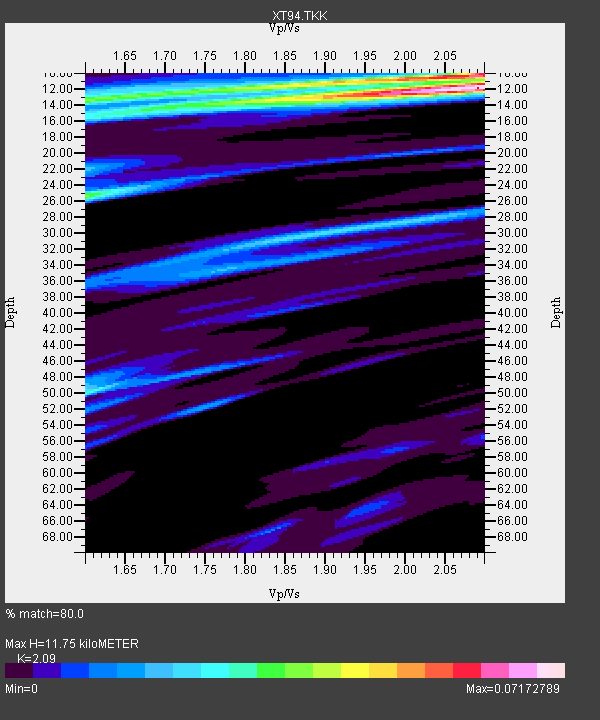
| Thickness Estimate: | 12 km |
| Thickness StdDev: | 3.7 km |
| Vp/Vs Estimate: | 2.09 |
| Vp/Vs StdDev: | 0.07 |
| Vs Estimate: | 2.029 km/s |
| Poisson's Ratio: | 0.35 |
| Peak Value: | 0.07 |
| Assumed Vp: | 4.24 km/s |
| Ps Weight: | 0.33333334 |
| PpPs Weight: | 0.33333334 |
| PsPs Weight: | 0.33333328 |
| Residual Complexity: | 0.704 |
| Nearby stations H: | +- |
| (2.0 deg) Vp/Vs: | +- |
2 with match > 90% ( 7.142857 %) and 4 with match > 80% ( 14.285714 %) out of 28.
Download stack as xyz text file.
Azimuth Distribution of Events:

Prior Results for this Station
| Study | Thickness | Vp/Vs | Vp | Vs | Poissons Ratio | Extra |
| EARS | 12 km | 2.09 | 4.24 km/s | 2.029 km/s | 0.35 | |
| Crust2.0 | 12 km | 2.19 | 4.24 km/s | 1.94 km/s | 0.37 | A0,normal oceanic, 0.07 km seds. |
| Global Maxima | 12 km | 2.09 | 4.24 km/s | 2.029 km/s | 0.35 | amp=0.07172789 |
| Local Maxima 1 | 10 km | 2.06 | 4.24 km/s | 2.061 km/s | 0.35 | amp=0.05298521 |
| Local Maxima 2 | 25 km | 1.60 | 4.24 km/s | 2.65 km/s | 0.18 | amp=0.037360683 |
| Local Maxima 3 | 13 km | 1.62 | 4.24 km/s | 2.613 km/s | 0.19 | amp=0.03198379 |
| Local Maxima 4 | 50 km | 1.60 | 4.24 km/s | 2.646 km/s | 0.18 | amp=0.029247645 |
| Predicted Arrivals for vertical incidence (zero ray parameter) | |
| Ps | 3.02 SECOND |
| PpPs | 8.56 SECOND |
| PsPs/PpSs | 11.58 SECOND |
Events Processed for this Station
Download zip of receiver functions as SAC
Plot maxima for each earthquake.
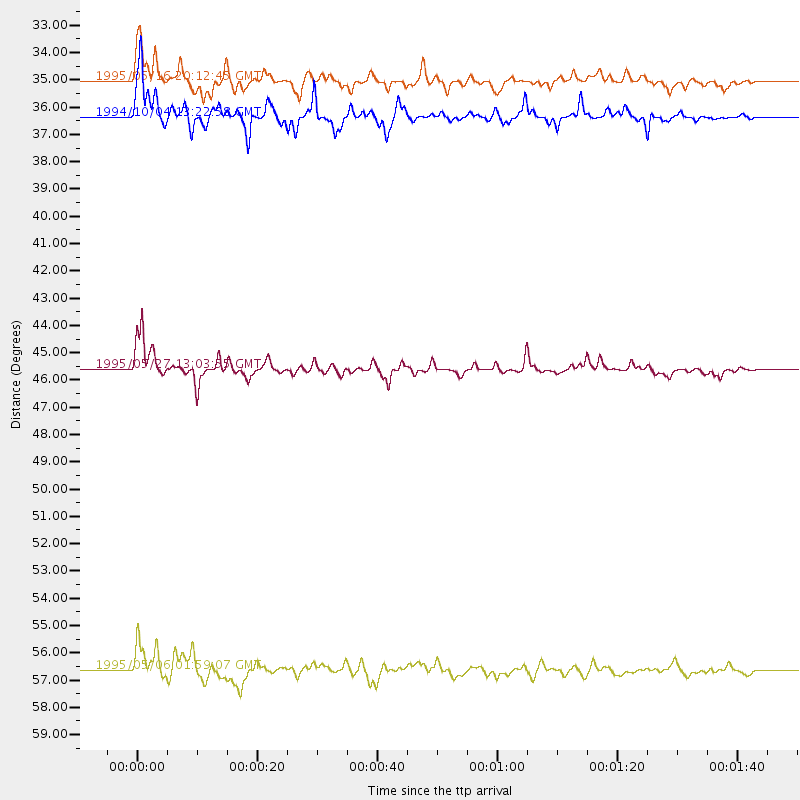
Events Used in the Stack
(4 events)| Radial Match | Distance | Baz | FERegion | Time | Lat/Lon | Depth | Magnitude |
| 92.66413 | 45.6 deg | 352.255 deg | Sakhalin, Russia | 1995/05/27 13:03:55 GMT | (52.6, 142.8) | 33 km | 6.6 MB, 7.6 MS, 7.0 UNKNOWN, 7.0 MW |
| 91.33378 | 35.0 deg | 150.251 deg | Southeast Of Loyalty Islands | 1995/05/16 20:12:45 GMT | (-23.0, 169.9) | 33 km | 6.8 MB, 7.7 MS, 7.7 UNKNOWN, 7.7 MW |
| 84.40196 | 56.6 deg | 294.968 deg | Myanmar-India Border Region | 1995/05/06 01:59:07 GMT | (25.0, 95.3) | 122 km | 6.4 MB, 6.5 UNKNOWN, 6.4 MW |
| 81.22001 | 36.3 deg | 354.417 deg | Kuril Islands | 1994/10/04 13:22:58 GMT | (43.7, 147.3) | 33 km | 7.4 MB, 8.1 MS, 8.3 UNKNOWN, 8.2 MW |
Losers
(24 events)| Radial Match | Distance | Baz | FERegion | Time | Lat/Lon | Depth | Magnitude | Reason |
| 78.60629 | 42.8 deg | 132.175 deg | Tonga Islands | 1995/07/28 14:29:12 GMT | (-21.1, -175.5) | 102 km | 6.1 MB, 6.5 UNKNOWN, 6.4 MW | |
| 76.31107 | 41.8 deg | 131.292 deg | Tonga Islands | 1995/10/06 11:39:36 GMT | (-20.0, -175.9) | 209 km | 5.7 MB, 6.4 UNKNOWN, 6.3 MW | |
| 76.21599 | 35.7 deg | 149.215 deg | Southeast Of Loyalty Islands | 1995/07/12 15:46:59 GMT | (-23.2, 170.8) | 33 km | 5.9 MB, 6.4 MS, 6.5 UNKNOWN, 6.4 MW | |
| 76.04778 | 83.6 deg | 149.465 deg | Pacific-Antarctic Ridge | 1995/08/23 13:14:42 GMT | (-56.8, -141.7) | 10 km | 5.9 MB, 5.6 MS, 5.5 UNKNOWN, 6.2 MW | |
| 75.511696 | 33.9 deg | 148.462 deg | Southeast Of Loyalty Islands | 1995/10/09 13:43:42 GMT | (-21.5, 170.1) | 119 km | 5.6 MB, 5.5 MS, 6.3 UNKNOWN, 6.3 MW | |
| 72.66869 | 44.3 deg | 138.826 deg | South Of Fiji Islands | 1995/10/14 08:00:41 GMT | (-25.6, -177.5) | 70 km | 5.9 MB, 6.2 UNKNOWN, 6.2 MW | |
| 70.481514 | 35.1 deg | 150.012 deg | Southeast Of Loyalty Islands | 1995/05/17 11:23:51 GMT | (-23.0, 170.1) | 33 km | 5.7 MB, 6.5 MS, 6.5 UNKNOWN, 6.2 MW | |
| 69.84205 | 34.3 deg | 148.436 deg | Southeast Of Loyalty Islands | 1995/08/17 05:35:37 GMT | (-21.8, 170.4) | 75 km | 5.5 MB, 6.1 UNKNOWN | |
| 65.428925 | 66.3 deg | 176.351 deg | Macquarie Island Region | 1995/10/13 15:22:23 GMT | (-58.8, 158.3) | 10 km | 5.6 MB, 5.9 MS, 6.1 UNKNOWN, 6.1 MW | |
| 65.05997 | 39.6 deg | 124.379 deg | Tonga Islands | 1995/10/02 23:48:23 GMT | (-15.0, -175.1) | 33 km | 5.5 MB, 5.9 MS, 6.0 UNKNOWN, 6.0 MW | |
| 59.32311 | 34.2 deg | 336.008 deg | Sea Of Japan | 1995/03/31 14:01:40 GMT | (38.2, 135.1) | 365 km | 6.0 MB, 6.2 UNKNOWN, 6.3 MW | |
| 59.143612 | 33.5 deg | 304.049 deg | Taiwan | 1995/06/25 06:59:05 GMT | (24.6, 121.7) | 47 km | 5.8 MB, 5.7 MS, 6.0 UNKNOWN, 6.0 MW | |
| 58.996662 | 42.5 deg | 142.003 deg | South Of Fiji Islands | 1994/10/27 22:20:31 GMT | (-25.8, 179.3) | 549 km | 5.9 MB, 6.8 UNKNOWN, 6.7 MW | |
| 57.49257 | 36.5 deg | 354.491 deg | Kuril Islands | 1994/10/05 20:39:47 GMT | (43.9, 147.4) | 33 km | 6.2 MB, 5.6 MS, 5.9 UNKNOWN | |
| 56.91006 | 36.2 deg | 354.134 deg | Kuril Islands | 1994/10/18 17:12:51 GMT | (43.6, 147.1) | 66 km | 6.1 MB, 6.1 UNKNOWN, 5.9 MW | |
| 52.586952 | 78.3 deg | 47.097 deg | Off Coast Of Oregon | 1994/10/27 17:45:57 GMT | (43.6, -127.3) | 10 km | 5.6 MB, 6.0 MS, 6.4 UNKNOWN, 6.3 MW | |
| 52.35438 | 41.5 deg | 123.449 deg | Tonga Islands | 1994/04/04 01:37:03 GMT | (-15.5, -173.2) | 33 km | 5.8 MB, 5.5 MS | |
| 45.788834 | 78.8 deg | 305.608 deg | Hindu Kush Region, Afghanistan | 1995/10/18 09:30:38 GMT | (36.4, 70.4) | 226 km | 5.4 MB, 6.2 UNKNOWN, 6.2 MW | |
| 42.19736 | 93.8 deg | 146.011 deg | Southern East Pacific Rise | 1995/09/08 01:15:28 GMT | (-56.2, -122.4) | 10 km | 5.2 MB, 6.3 MS, 6.3 UNKNOWN, 6.3 MW | |
| 41.633957 | 33.2 deg | 149.733 deg | Southeast Of Loyalty Islands | 1995/03/22 22:39:20 GMT | (-21.3, 169.1) | 33 km | 5.6 MS, 5.2 MB, 5.8 UNKNOWN | |
| 40.65864 | 78.4 deg | 305.647 deg | Hindu Kush Region, Afghanistan | 1995/05/16 03:35:03 GMT | (36.5, 70.9) | 190 km | 5.7 MB, 5.9 UNKNOWN, 5.8 MW | |
| 32.154503 | 50.3 deg | 24.086 deg | Andreanof Islands, Aleutian Is. | 1994/04/05 09:35:46 GMT | (51.3, -178.1) | 33 km | 5.8 MB, 5.9 MS, 6.2 UNKNOWN, 6.0 MW | |
| 29.21876 | 45.1 deg | 6.282 deg | Off East Coast Of Kamchatka | 1995/04/01 05:50:20 GMT | (52.3, 159.1) | 47 km | 5.9 MB, 5.6 MS, 5.3 UNKNOWN, 6.0 MW | |
| 15.252966 | 65.0 deg | 312.545 deg | Southern Xinjiang, China | 1995/05/15 04:05:58 GMT | (41.7, 88.8) | 0.0 km | 6.1 MB |
