
Station XT FWGP - XT.FWGP
Network: XT97 - Colorado BB Array - Lodore
Nearby stations (2 deg radius)
| Station | Name | (Lat, Lon) | Start / End | Elevation |
| FWGP | XT.FWGP | (40.96, -108.77) | 1997-08-01 / 1998-07-15 | 2077 m |
| Crust2 Type: | Q4,orogen/43km no ice, Tethian Belt, 5 km seds. |
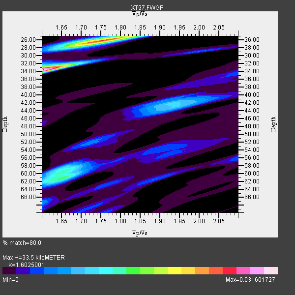
| Thickness Estimate: | 34 km |
| Thickness StdDev: | 9.9 km |
| Vp/Vs Estimate: | 1.60 |
| Vp/Vs StdDev: | 0.06 |
| Vs Estimate: | 3.873 km/s |
| Poisson's Ratio: | 0.18 |
| Peak Value: | 0.03 |
| Assumed Vp: | 6.207 km/s |
| Ps Weight: | 0.33333334 |
| PpPs Weight: | 0.33333334 |
| PsPs Weight: | 0.33333328 |
| Residual Complexity: | 0.859 |
| Nearby stations H: | +- |
| (2.0 deg) Vp/Vs: | +- |
6 with match > 90% ( 16.216217 %) and 12 with match > 80% ( 32.432434 %) out of 37.
Download stack as xyz text file.
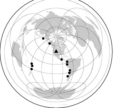
Azimuth Distribution of Events:
Prior Results for this Station
| Study | Thickness | Vp/Vs | Vp | Vs | Poissons Ratio | Extra |
| EARS | 34 km | 1.60 | 6.207 km/s | 3.873 km/s | 0.18 | |
| Crust2.0 | 43 km | 1.76 | 6.207 km/s | 3.535 km/s | 0.26 | Q4,orogen/43km no ice, Tethian Belt, 5 km seds. |
| Global Maxima | 34 km | 1.60 | 6.207 km/s | 3.873 km/s | 0.18 | amp=0.031601727 |
| Local Maxima 1 | 26 km | 1.75 | 6.207 km/s | 3.542 km/s | 0.26 | amp=0.024620911 |
| Local Maxima 2 | 61 km | 1.65 | 6.207 km/s | 3.75 km/s | 0.21 | amp=0.01544128 |
| Local Maxima 3 | 59 km | 1.65 | 6.207 km/s | 3.756 km/s | 0.21 | amp=0.011397185 |
| Local Maxima 4 | 42 km | 1.93 | 6.207 km/s | 3.22 km/s | 0.32 | amp=0.00936408 |
| Predicted Arrivals for vertical incidence (zero ray parameter) | |
| Ps | 3.25 SECOND |
| PpPs | 14.05 SECOND |
| PsPs/PpSs | 17.30 SECOND |
Events Processed for this Station
Download zip of receiver functions as SAC
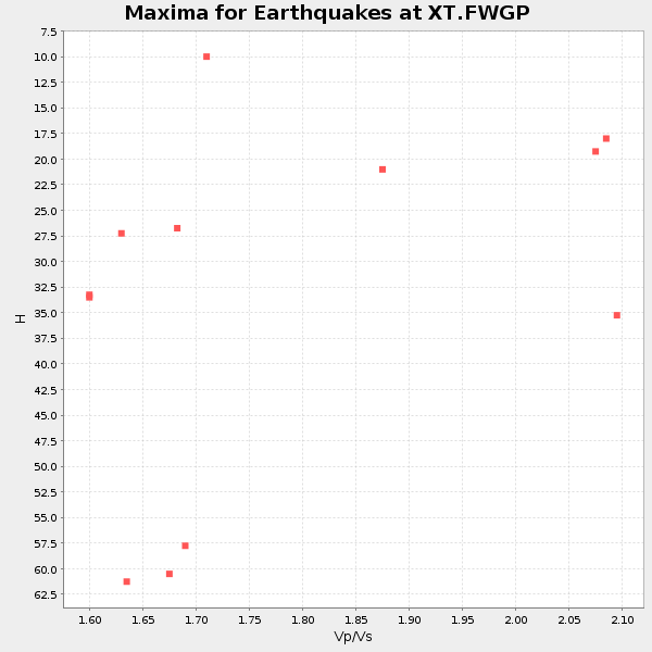
Plot maxima for each earthquake.
Events Used in the Stack
(12 events)| Radial Match | Distance | Baz | FERegion | Time | Lat/Lon | Depth | Magnitude |
| 97.48781 | 88.9 deg | 239.321 deg | South Of Fiji Islands | 1997/10/14 09:53:18 GMT | (-22.1, -176.8) | 167 km | 6.7 MB, 7.7 UNKNOWN, 7.4 ME |
| 94.917984 | 79.5 deg | 147.822 deg | Near Coast Of Central Chile | 1997/10/15 01:03:33 GMT | (-30.9, -71.2) | 58 km | 6.8 MB, 6.8 MS, 7.3 UNKNOWN, 7.1 MW |
| 94.672905 | 86.6 deg | 154.712 deg | Off Coast Of Southern Chile | 1998/04/01 22:42:56 GMT | (-40.3, -74.9) | 9.0 km | 6.2 MB, 6.0 MS, 6.7 UNKNOWN, 6.6 ME |
| 91.93825 | 87.3 deg | 244.071 deg | Fiji Islands Region | 1998/03/29 19:48:16 GMT | (-17.6, -179.1) | 537 km | 6.5 MB, 7.2 UNKNOWN, 7.1 MW |
| 91.12415 | 59.3 deg | 315.22 deg | Off East Coast Of Kamchatka | 1998/06/01 05:34:03 GMT | (52.9, 160.1) | 44 km | 6.2 MB, 6.3 MS, 6.5 UNKNOWN, 6.4 MW |
| 90.87178 | 53.8 deg | 138.985 deg | Northern Peru | 1997/10/28 06:15:17 GMT | (-4.4, -76.7) | 112 km | 6.6 MB, 6.3 MS, 7.2 UNKNOWN, 6.6 ME |
| 89.56752 | 73.8 deg | 143.559 deg | Near Coast Of Northern Chile | 1998/01/30 12:16:08 GMT | (-23.9, -70.2) | 42 km | 6.3 MB, 6.5 MS, 7.0 UNKNOWN, 6.7 ME |
| 88.5916 | 79.5 deg | 147.993 deg | Near Coast Of Central Chile | 1998/01/12 10:14:07 GMT | (-31.0, -71.4) | 35 km | 5.8 MB, 6.2 MS, 6.6 UNKNOWN, 6.2 ME |
| 85.51508 | 96.2 deg | 234.801 deg | Kermadec Islands, New Zealand | 1998/07/09 14:45:39 GMT | (-30.5, -179.0) | 130 km | 6.2 MB, 6.2 MS, 6.9 UNKNOWN, 6.4 ME |
| 85.39901 | 33.4 deg | 321.006 deg | Southern Alaska | 1998/07/09 19:39:43 GMT | (60.5, -153.2) | 145 km | 5.3 MB, 6.2 UNKNOWN, 6.2 MW |
| 83.389915 | 47.4 deg | 132.366 deg | Colombia | 1997/09/02 12:13:22 GMT | (3.8, -75.7) | 199 km | 6.5 MB, 6.8 UNKNOWN, 6.4 ME |
| 82.558136 | 30.5 deg | 145.389 deg | Guatemala | 1998/01/10 08:20:05 GMT | (14.4, -91.5) | 33 km | 6.1 MB, 6.2 MS, 6.6 UNKNOWN, 6.6 ME |
Losers
(25 events)| Radial Match | Distance | Baz | FERegion | Time | Lat/Lon | Depth | Magnitude | Reason |
| 82.60855 | 87.3 deg | 243.955 deg | Fiji Islands Region | 1998/03/29 20:38:40 GMT | (-17.7, -179.0) | 530 km | 5.6 MB | |
| 79.20717 | 94.1 deg | 235.246 deg | Kermadec Islands Region | 1997/09/20 16:11:32 GMT | (-28.7, -177.6) | 30 km | 6.1 MB, 7.0 MS, 7.2 UNKNOWN, 6.7 ME | |
| 79.0176 | 65.8 deg | 136.806 deg | Peru-Bolivia Border Region | 1997/11/28 22:53:41 GMT | (-13.7, -68.8) | 586 km | 6.4 MB, 6.6 UNKNOWN, 6.6 MW | |
| 78.36761 | 58.3 deg | 138.722 deg | Peru-Brazil Border Region | 1998/04/03 22:01:48 GMT | (-8.1, -74.2) | 165 km | 6.1 MB, 5.6 MS, 6.6 UNKNOWN, 6.6 MW | |
| 75.13873 | 49.3 deg | 307.726 deg | Rat Islands, Aleutian Islands | 1997/12/17 04:38:51 GMT | (51.2, 178.9) | 20 km | 5.8 MB, 6.5 MS, 6.7 UNKNOWN, 6.1 ME | |
| 70.77975 | 30.5 deg | 145.372 deg | Guatemala | 1998/03/03 02:24:43 GMT | (14.4, -91.5) | 63 km | 5.5 MB, 5.4 MS, 6.2 UNKNOWN, 6.1 MW | |
| 70.11915 | 81.4 deg | 145.537 deg | San Juan Province, Argentina | 1998/06/07 16:10:46 GMT | (-31.5, -67.8) | 113 km | 5.6 MB, 5.9 UNKNOWN, 5.9 MW | |
| 68.2833 | 31.5 deg | 143.994 deg | Near Coast Of Guatemala | 1997/12/22 10:03:45 GMT | (13.7, -90.3) | 59 km | 5.1 MB, 6.1 UNKNOWN, 5.2 MD | |
| 67.123985 | 32.2 deg | 141.349 deg | El Salvador | 1997/12/18 15:02:00 GMT | (13.8, -88.7) | 182 km | 5.3 MB, 6.1 UNKNOWN, 6.0 MW | |
| 66.92801 | 92.7 deg | 291.289 deg | Mariana Islands | 1998/05/15 05:58:06 GMT | (14.2, 144.9) | 154 km | 5.7 MB, 6.0 UNKNOWN, 6.0 MW | |
| 65.89464 | 31.4 deg | 144.766 deg | Near Coast Of Guatemala | 1998/05/10 06:05:58 GMT | (13.7, -90.7) | 33 km | 5.3 MB, 5.9 MS, 6.3 UNKNOWN, 5.3 MD | |
| 65.2425 | 58.1 deg | 315.799 deg | Off East Coast Of Kamchatka | 1997/12/05 11:35:19 GMT | (53.9, 161.6) | 33 km | 5.7 MB | |
| 63.99227 | 47.3 deg | 132.348 deg | Colombia | 1997/12/11 07:56:28 GMT | (3.9, -75.8) | 178 km | 6.0 MB, 6.4 UNKNOWN, 6.3 MW | |
| 63.709003 | 76.7 deg | 310.362 deg | Off East Coast Of Honshu, Japan | 1998/05/30 18:18:15 GMT | (39.0, 143.4) | 33 km | 5.7 MB, 5.7 MS, 6.2 UNKNOWN, 6.0 MW | |
| 63.52594 | 60.6 deg | 140.543 deg | Central Peru | 1998/02/19 04:21:30 GMT | (-11.0, -74.4) | 33 km | 5.8 MB, 5.4 MS, 6.0 UNKNOWN, 5.9 MW | |
| 61.973408 | 95.3 deg | 234.423 deg | Kermadec Islands, New Zealand | 1998/06/20 20:24:45 GMT | (-30.1, -177.9) | 57 km | 5.7 MB, 6.0 UNKNOWN, 6.0 MW | |
| 61.895065 | 88.7 deg | 240.898 deg | Fiji Islands Region | 1997/08/25 11:59:00 GMT | (-20.8, -177.8) | 394 km | 5.5 UNKNOWN, 5.3 MB | |
| 61.753094 | 89.4 deg | 241.536 deg | Fiji Islands Region | 1997/10/17 15:02:00 GMT | (-20.9, -178.8) | 579 km | 5.3 MB, 6.0 UNKNOWN, 6.0 MW | |
| 61.31082 | 54.7 deg | 320.026 deg | Kamchatka Peninsula, Russia | 1998/04/15 15:23:06 GMT | (58.5, 164.4) | 33 km | 5.6 MB, 5.5 MS, 6.0 UNKNOWN, 5.9 MW | |
| 57.218155 | 97.1 deg | 311.874 deg | Southwestern Ryukyu Isl., Japan | 1997/08/13 04:45:04 GMT | (25.0, 125.8) | 55 km | 6.0 MB, 5.6 MS, 6.1 UNKNOWN, 6.1 MW | |
| 51.946583 | 78.3 deg | 312.179 deg | Eastern Honshu, Japan | 1997/10/26 19:06:44 GMT | (39.3, 140.5) | 134 km | 5.6 UNKNOWN, 5.2 MB | |
| 49.99186 | 73.3 deg | 141.315 deg | Northern Chile | 1997/09/28 23:13:13 GMT | (-22.4, -68.4) | 107 km | 5.7 MB, 5.6 UNKNOWN, 5.6 MW | |
| 49.352184 | 92.2 deg | 240.119 deg | South Of Fiji Islands | 1998/04/14 03:41:22 GMT | (-23.8, -179.9) | 499 km | 5.5 MB, 6.2 UNKNOWN, 6.1 MW | |
| 47.446987 | 80.9 deg | 309.278 deg | Near East Coast Of Honshu, Japan | 1998/06/14 13:17:08 GMT | (35.4, 140.5) | 45 km | 5.5 MB, 5.3 MS, 5.8 UNKNOWN, 5.8 MW | |
| 39.472397 | 76.0 deg | 311.397 deg | Off East Coast Of Honshu, Japan | 1998/05/14 18:56:23 GMT | (40.3, 143.3) | 33 km | 5.8 MB, 5.7 MS, 5.9 UNKNOWN |
