
Station XT GRAN - XT.GRAN
Network: XT97 - Colorado BB Array - Lodore
Nearby stations (2 deg radius)
| Station | Name | (Lat, Lon) | Start / End | Elevation |
| GRAN | XT.GRAN | (41.11, -108.64) | 1997-08-01 / 1998-07-15 | 2164 m |
| Crust2 Type: | Q4,orogen/43km no ice, Tethian Belt, 5 km seds. |
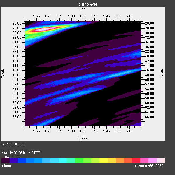
| Thickness Estimate: | 28 km |
| Thickness StdDev: | 3.1 km |
| Vp/Vs Estimate: | 1.68 |
| Vp/Vs StdDev: | 0.02 |
| Vs Estimate: | 3.689 km/s |
| Poisson's Ratio: | 0.23 |
| Peak Value: | 0.03 |
| Assumed Vp: | 6.207 km/s |
| Ps Weight: | 0.33333334 |
| PpPs Weight: | 0.33333334 |
| PsPs Weight: | 0.33333328 |
| Residual Complexity: | 0.465 |
| Nearby stations H: | +- |
| (2.0 deg) Vp/Vs: | +- |
5 with match > 90% ( 13.157895 %) and 17 with match > 80% ( 44.736843 %) out of 38.
Download stack as xyz text file.
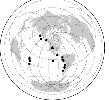
Azimuth Distribution of Events:
Prior Results for this Station
| Study | Thickness | Vp/Vs | Vp | Vs | Poissons Ratio | Extra |
| EARS | 28 km | 1.68 | 6.207 km/s | 3.689 km/s | 0.23 | |
| Crust2.0 | 43 km | 1.76 | 6.207 km/s | 3.535 km/s | 0.26 | Q4,orogen/43km no ice, Tethian Belt, 5 km seds. |
| Global Maxima | 28 km | 1.68 | 6.207 km/s | 3.689 km/s | 0.23 | amp=0.026613759 |
| Local Maxima 1 | 31 km | 1.64 | 6.207 km/s | 3.785 km/s | 0.20 | amp=0.00882379 |
| Local Maxima 2 | 47 km | 2.02 | 6.207 km/s | 3.077 km/s | 0.34 | amp=0.007623113 |
| Local Maxima 3 | 56 km | 1.83 | 6.207 km/s | 3.401 km/s | 0.29 | amp=0.006299884 |
| Local Maxima 4 | 30 km | 1.66 | 6.207 km/s | 3.745 km/s | 0.21 | amp=0.004989842 |
| Predicted Arrivals for vertical incidence (zero ray parameter) | |
| Ps | 3.11 SECOND |
| PpPs | 12.21 SECOND |
| PsPs/PpSs | 15.32 SECOND |
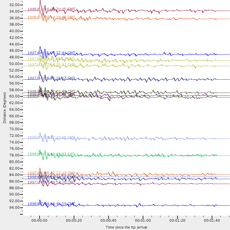
Events Processed for this Station
Download zip of receiver functions as SAC
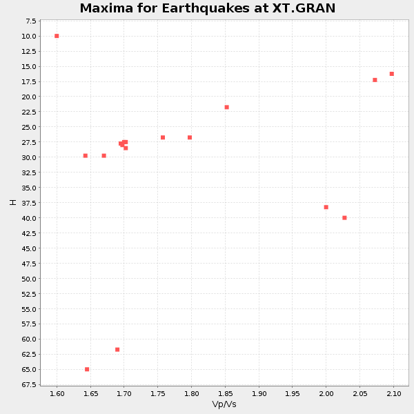
Plot maxima for each earthquake.
Events Used in the Stack
(17 events)| Radial Match | Distance | Baz | FERegion | Time | Lat/Lon | Depth | Magnitude |
| 95.84233 | 89.1 deg | 239.403 deg | South Of Fiji Islands | 1997/10/14 09:53:18 GMT | (-22.1, -176.8) | 167 km | 6.7 MB, 7.7 UNKNOWN, 7.4 ME |
| 93.44488 | 79.6 deg | 147.933 deg | Near Coast Of Central Chile | 1997/10/15 01:03:33 GMT | (-30.9, -71.2) | 58 km | 6.8 MB, 6.8 MS, 7.3 UNKNOWN, 7.1 MW |
| 92.75324 | 53.9 deg | 139.189 deg | Northern Peru | 1997/10/28 06:15:17 GMT | (-4.4, -76.7) | 112 km | 6.6 MB, 6.3 MS, 7.2 UNKNOWN, 6.6 ME |
| 91.41555 | 86.7 deg | 154.803 deg | Off Coast Of Southern Chile | 1998/04/01 22:42:56 GMT | (-40.3, -74.9) | 9.0 km | 6.2 MB, 6.0 MS, 6.7 UNKNOWN, 6.6 ME |
| 90.0696 | 45.3 deg | 175.871 deg | Central East Pacific Rise | 1997/08/15 07:37:49 GMT | (-4.4, -105.7) | 10 km | 5.3 MB, 5.8 MS, 6.2 UNKNOWN, 6.1 MW |
| 88.02071 | 73.9 deg | 143.688 deg | Near Coast Of Northern Chile | 1998/01/30 12:16:08 GMT | (-23.9, -70.2) | 42 km | 6.3 MB, 6.5 MS, 7.0 UNKNOWN, 6.7 ME |
| 87.93999 | 59.3 deg | 315.202 deg | Off East Coast Of Kamchatka | 1998/06/01 05:34:03 GMT | (52.9, 160.1) | 44 km | 6.2 MB, 6.3 MS, 6.5 UNKNOWN, 6.4 MW |
| 86.70653 | 33.3 deg | 320.838 deg | Southern Alaska | 1998/07/09 19:39:43 GMT | (60.5, -153.2) | 145 km | 5.3 MB, 6.2 UNKNOWN, 6.2 MW |
| 86.37922 | 30.5 deg | 145.743 deg | Guatemala | 1998/01/10 08:20:05 GMT | (14.4, -91.5) | 33 km | 6.1 MB, 6.2 MS, 6.6 UNKNOWN, 6.6 ME |
| 85.54297 | 79.6 deg | 148.105 deg | Near Coast Of Central Chile | 1998/01/12 10:14:07 GMT | (-31.0, -71.4) | 35 km | 5.8 MB, 6.2 MS, 6.6 UNKNOWN, 6.2 ME |
| 85.248856 | 58.3 deg | 138.907 deg | Peru-Brazil Border Region | 1998/04/03 22:01:48 GMT | (-8.1, -74.2) | 165 km | 6.1 MB, 5.6 MS, 6.6 UNKNOWN, 6.6 MW |
| 85.1974 | 86.0 deg | 245.656 deg | Fiji Islands Region | 1997/08/08 22:27:19 GMT | (-15.5, -179.1) | 10 km | 5.7 MB, 6.6 MS, 6.6 UNKNOWN, 6.4 MW |
| 84.46243 | 87.4 deg | 244.149 deg | Fiji Islands Region | 1998/03/29 19:48:16 GMT | (-17.6, -179.1) | 537 km | 6.5 MB, 7.2 UNKNOWN, 7.1 MW |
| 83.920654 | 47.4 deg | 132.605 deg | Colombia | 1997/09/02 12:13:22 GMT | (3.8, -75.7) | 199 km | 6.5 MB, 6.8 UNKNOWN, 6.4 ME |
| 83.27406 | 96.4 deg | 234.89 deg | Kermadec Islands, New Zealand | 1998/07/09 14:45:39 GMT | (-30.5, -179.0) | 130 km | 6.2 MB, 6.2 MS, 6.9 UNKNOWN, 6.4 ME |
| 83.06733 | 49.3 deg | 307.661 deg | Rat Islands, Aleutian Islands | 1997/12/17 04:38:51 GMT | (51.2, 178.9) | 20 km | 5.8 MB, 6.5 MS, 6.7 UNKNOWN, 6.1 ME |
| 80.47193 | 59.9 deg | 314.725 deg | Off East Coast Of Kamchatka | 1998/05/27 20:41:37 GMT | (52.2, 159.5) | 60 km | 5.5 MB, 6.0 UNKNOWN, 5.9 MW |
Losers
(21 events)| Radial Match | Distance | Baz | FERegion | Time | Lat/Lon | Depth | Magnitude | Reason |
| 83.85797 | 87.0 deg | 238.329 deg | Tonga Islands | 1997/09/10 12:57:07 GMT | (-21.3, -174.4) | 10 km | 5.7 MB, 6.1 MS, 6.1 UNKNOWN, 5.9 MW | |
| 79.38423 | 47.3 deg | 132.588 deg | Colombia | 1997/12/11 07:56:28 GMT | (3.9, -75.8) | 178 km | 6.0 MB, 6.4 UNKNOWN, 6.3 MW | |
| 78.95638 | 30.5 deg | 145.726 deg | Guatemala | 1998/03/03 02:24:43 GMT | (14.4, -91.5) | 63 km | 5.5 MB, 5.4 MS, 6.2 UNKNOWN, 6.1 MW | |
| 78.171394 | 31.5 deg | 145.111 deg | Near Coast Of Guatemala | 1998/05/10 06:05:58 GMT | (13.7, -90.7) | 33 km | 5.3 MB, 5.9 MS, 6.3 UNKNOWN, 5.3 MD | |
| 77.607155 | 58.0 deg | 315.776 deg | Off East Coast Of Kamchatka | 1997/12/05 11:35:19 GMT | (53.9, 161.6) | 33 km | 5.7 MB | |
| 77.195496 | 76.7 deg | 310.404 deg | Off East Coast Of Honshu, Japan | 1998/05/30 18:18:15 GMT | (39.0, 143.4) | 33 km | 5.7 MB, 5.7 MS, 6.2 UNKNOWN, 6.0 MW | |
| 76.721085 | 94.3 deg | 235.333 deg | Kermadec Islands Region | 1997/09/20 16:11:32 GMT | (-28.7, -177.6) | 30 km | 6.1 MB, 7.0 MS, 7.2 UNKNOWN, 6.7 ME | |
| 74.353806 | 65.9 deg | 136.964 deg | Peru-Bolivia Border Region | 1997/11/28 22:53:41 GMT | (-13.7, -68.8) | 586 km | 6.4 MB, 6.6 UNKNOWN, 6.6 MW | |
| 72.9029 | 81.5 deg | 145.644 deg | San Juan Province, Argentina | 1998/06/07 16:10:46 GMT | (-31.5, -67.8) | 113 km | 5.6 MB, 5.9 UNKNOWN, 5.9 MW | |
| 68.87007 | 97.1 deg | 311.977 deg | Southwestern Ryukyu Isl., Japan | 1997/08/13 04:45:04 GMT | (25.0, 125.8) | 55 km | 6.0 MB, 5.6 MS, 6.1 UNKNOWN, 6.1 MW | |
| 68.50444 | 57.8 deg | 315.729 deg | Off East Coast Of Kamchatka | 1997/12/06 10:59:10 GMT | (54.0, 161.9) | 33 km | 5.7 MB, 5.8 MS, 6.1 UNKNOWN, 6.1 MW | |
| 63.544693 | 32.2 deg | 141.692 deg | El Salvador | 1997/12/18 15:02:00 GMT | (13.8, -88.7) | 182 km | 5.3 MB, 6.1 UNKNOWN, 6.0 MW | |
| 61.65349 | 30.4 deg | 147.326 deg | Near Coast Of Chiapas, Mexico | 1997/12/25 22:16:19 GMT | (14.1, -92.3) | 10 km | 5.4 MB, 5.3 MS, 5.8 UNKNOWN, 5.5 MD | |
| 59.21016 | 95.4 deg | 239.356 deg | South Of Fiji Islands | 1997/09/04 04:23:37 GMT | (-26.6, 178.3) | 625 km | 6.3 MB, 6.8 UNKNOWN, 6.5 ME | |
| 53.44165 | 80.9 deg | 309.333 deg | Near East Coast Of Honshu, Japan | 1998/06/14 13:17:08 GMT | (35.4, 140.5) | 45 km | 5.5 MB, 5.3 MS, 5.8 UNKNOWN, 5.8 MW | |
| 53.41704 | 78.2 deg | 312.226 deg | Eastern Honshu, Japan | 1997/10/26 19:06:44 GMT | (39.3, 140.5) | 134 km | 5.6 UNKNOWN, 5.2 MB | |
| 50.42398 | 92.1 deg | 241.915 deg | South Of Fiji Islands | 1998/01/27 21:05:44 GMT | (-22.4, 179.0) | 610 km | 5.6 MB, 6.5 UNKNOWN, 6.4 MW | |
| 49.59859 | 95.5 deg | 234.511 deg | Kermadec Islands, New Zealand | 1998/06/20 20:24:45 GMT | (-30.1, -177.9) | 57 km | 5.7 MB, 6.0 UNKNOWN, 6.0 MW | |
| 46.619495 | 92.8 deg | 291.379 deg | Mariana Islands | 1998/05/15 05:58:06 GMT | (14.2, 144.9) | 154 km | 5.7 MB, 6.0 UNKNOWN, 6.0 MW | |
| 43.153812 | 89.6 deg | 241.618 deg | Fiji Islands Region | 1997/10/17 15:02:00 GMT | (-20.9, -178.8) | 579 km | 5.3 MB, 6.0 UNKNOWN, 6.0 MW | |
| 39.7192 | 88.8 deg | 240.979 deg | Fiji Islands Region | 1997/08/25 11:59:00 GMT | (-20.8, -177.8) | 394 km | 5.5 UNKNOWN, 5.3 MB |
