
Station XT JNMT - XT.JNMT
Network: XT97 - Colorado BB Array - Lodore
Nearby stations (2 deg radius)
| Station | Name | (Lat, Lon) | Start / End | Elevation |
| JNMT | XT.JNMT | (40.46, -108.02) | 1997-08-01 / 1998-07-15 | 2231 m |
| Crust2 Type: | Q4,orogen/43km no ice, Tethian Belt, 5 km seds. |
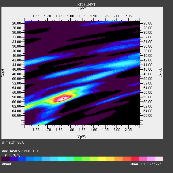
| Thickness Estimate: | 58 km |
| Thickness StdDev: | 5.4 km |
| Vp/Vs Estimate: | 1.77 |
| Vp/Vs StdDev: | 0.10 |
| Vs Estimate: | 3.512 km/s |
| Poisson's Ratio: | 0.26 |
| Peak Value: | 0.01 |
| Assumed Vp: | 6.207 km/s |
| Ps Weight: | 0.33333334 |
| PpPs Weight: | 0.33333334 |
| PsPs Weight: | 0.33333328 |
| Residual Complexity: | 0.617 |
| Nearby stations H: | +- |
| (2.0 deg) Vp/Vs: | +- |
14 with match > 90% ( 41.17647 %) and 19 with match > 80% ( 55.882355 %) out of 34.
Download stack as xyz text file.
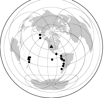
Azimuth Distribution of Events:
Prior Results for this Station
| Study | Thickness | Vp/Vs | Vp | Vs | Poissons Ratio | Extra |
| EARS | 58 km | 1.77 | 6.207 km/s | 3.512 km/s | 0.26 | |
| Crust2.0 | 43 km | 1.76 | 6.207 km/s | 3.535 km/s | 0.26 | Q4,orogen/43km no ice, Tethian Belt, 5 km seds. |
| Global Maxima | 58 km | 1.77 | 6.207 km/s | 3.512 km/s | 0.26 | amp=0.0130265225 |
| Local Maxima 1 | 58 km | 1.75 | 6.207 km/s | 3.552 km/s | 0.26 | amp=0.007283372 |
| Local Maxima 2 | 63 km | 1.60 | 6.207 km/s | 3.879 km/s | 0.18 | amp=0.006258852 |
| Local Maxima 3 | 70 km | 1.67 | 6.207 km/s | 3.717 km/s | 0.22 | amp=0.0047834245 |
| Local Maxima 4 | 44 km | 2.01 | 6.207 km/s | 3.088 km/s | 0.34 | amp=0.0046177288 |
| Predicted Arrivals for vertical incidence (zero ray parameter) | |
| Ps | 7.23 SECOND |
| PpPs | 26.08 SECOND |
| PsPs/PpSs | 33.32 SECOND |
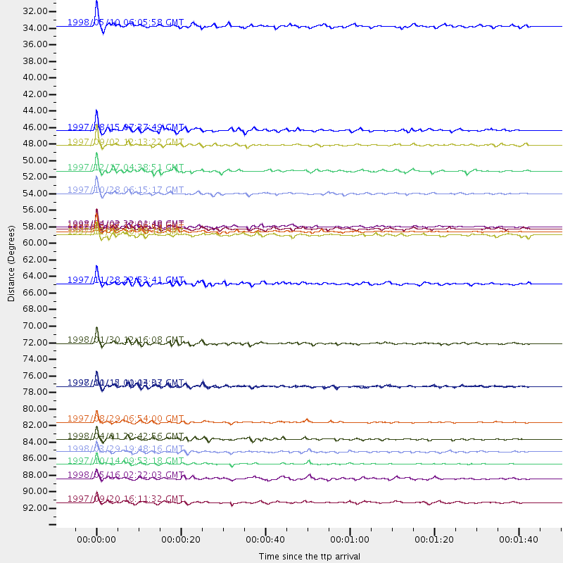
Events Processed for this Station
Download zip of receiver functions as SAC
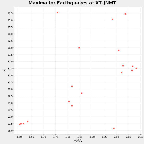
Plot maxima for each earthquake.
Events Used in the Stack
(19 events)| Radial Match | Distance | Baz | FERegion | Time | Lat/Lon | Depth | Magnitude |
| 98.95261 | 89.2 deg | 239.819 deg | South Of Fiji Islands | 1997/10/14 09:53:18 GMT | (-22.1, -176.8) | 167 km | 6.7 MB, 7.7 UNKNOWN, 7.4 ME |
| 98.46329 | 78.8 deg | 148.349 deg | Near Coast Of Central Chile | 1997/10/15 01:03:33 GMT | (-30.9, -71.2) | 58 km | 6.8 MB, 6.8 MS, 7.3 UNKNOWN, 7.1 MW |
| 97.650505 | 83.5 deg | 243.88 deg | Tonga Islands | 1997/08/29 06:54:00 GMT | (-15.2, -175.6) | 33 km | 5.6 MB, 6.4 MS, 6.5 UNKNOWN, 6.4 MW |
| 97.12673 | 58.1 deg | 317.081 deg | Near East Coast Of Kamchatka | 1997/12/05 11:26:54 GMT | (54.8, 162.0) | 33 km | 6.3 MB, 7.6 MS, 7.9 UNKNOWN, 7.3 ME |
| 96.88581 | 87.6 deg | 244.588 deg | Fiji Islands Region | 1998/03/29 19:48:16 GMT | (-17.6, -179.1) | 537 km | 6.5 MB, 7.2 UNKNOWN, 7.1 MW |
| 96.72108 | 53.1 deg | 139.547 deg | Northern Peru | 1997/10/28 06:15:17 GMT | (-4.4, -76.7) | 112 km | 6.6 MB, 6.3 MS, 7.2 UNKNOWN, 6.6 ME |
| 95.201324 | 73.1 deg | 144.092 deg | Near Coast Of Northern Chile | 1998/01/30 12:16:08 GMT | (-23.9, -70.2) | 42 km | 6.3 MB, 6.5 MS, 7.0 UNKNOWN, 6.7 ME |
| 93.98476 | 85.9 deg | 155.218 deg | Off Coast Of Southern Chile | 1998/04/01 22:42:56 GMT | (-40.3, -74.9) | 9.0 km | 6.2 MB, 6.0 MS, 6.7 UNKNOWN, 6.6 ME |
| 93.47588 | 46.6 deg | 132.865 deg | Colombia | 1997/09/02 12:13:22 GMT | (3.8, -75.7) | 199 km | 6.5 MB, 6.8 UNKNOWN, 6.4 ME |
| 92.94169 | 78.8 deg | 148.521 deg | Near Coast Of Central Chile | 1998/01/12 10:14:07 GMT | (-31.0, -71.4) | 35 km | 5.8 MB, 6.2 MS, 6.6 UNKNOWN, 6.2 ME |
| 91.91876 | 57.8 deg | 316.634 deg | Near East Coast Of Kamchatka | 1997/12/07 17:56:18 GMT | (54.7, 162.9) | 33 km | 5.6 MB, 6.0 MS, 6.3 UNKNOWN, 6.1 MW |
| 91.81044 | 44.7 deg | 176.705 deg | Central East Pacific Rise | 1997/08/15 07:37:49 GMT | (-4.4, -105.7) | 10 km | 5.3 MB, 5.8 MS, 6.2 UNKNOWN, 6.1 MW |
| 91.74877 | 30.7 deg | 145.548 deg | Near Coast Of Guatemala | 1998/05/10 06:05:58 GMT | (13.7, -90.7) | 33 km | 5.3 MB, 5.9 MS, 6.3 UNKNOWN, 5.3 MD |
| 91.13283 | 65.1 deg | 137.325 deg | Peru-Bolivia Border Region | 1997/11/28 22:53:41 GMT | (-13.7, -68.8) | 586 km | 6.4 MB, 6.6 UNKNOWN, 6.6 MW |
| 89.45181 | 94.3 deg | 235.678 deg | Kermadec Islands Region | 1997/09/20 16:11:32 GMT | (-28.7, -177.6) | 30 km | 6.1 MB, 7.0 MS, 7.2 UNKNOWN, 6.7 ME |
| 88.73849 | 57.5 deg | 139.269 deg | Peru-Brazil Border Region | 1998/04/03 22:01:48 GMT | (-8.1, -74.2) | 165 km | 6.1 MB, 5.6 MS, 6.6 UNKNOWN, 6.6 MW |
| 87.505775 | 50.1 deg | 308.253 deg | Rat Islands, Aleutian Islands | 1997/12/17 04:38:51 GMT | (51.2, 178.9) | 20 km | 5.8 MB, 6.5 MS, 6.7 UNKNOWN, 6.1 ME |
| 82.30923 | 91.1 deg | 241.503 deg | South Of Fiji Islands | 1998/05/16 02:22:03 GMT | (-22.2, -179.5) | 586 km | 6.1 MB, 6.8 UNKNOWN |
| 82.27167 | 58.6 deg | 316.203 deg | Off East Coast Of Kamchatka | 1997/12/06 10:59:10 GMT | (54.0, 161.9) | 33 km | 5.7 MB, 5.8 MS, 6.1 UNKNOWN, 6.1 MW |
Losers
(15 events)| Radial Match | Distance | Baz | FERegion | Time | Lat/Lon | Depth | Magnitude | Reason |
| 77.13223 | 31.4 deg | 142.05 deg | El Salvador | 1997/12/18 15:02:00 GMT | (13.8, -88.7) | 182 km | 5.3 MB, 6.1 UNKNOWN, 6.0 MW | |
| 75.31042 | 58.8 deg | 316.249 deg | Off East Coast Of Kamchatka | 1997/12/05 11:35:19 GMT | (53.9, 161.6) | 33 km | 5.7 MB | |
| 75.010574 | 89.8 deg | 238.306 deg | South Of Fiji Islands | 1998/04/11 00:44:35 GMT | (-23.6, -176.1) | 33 km | 5.7 MB, 6.1 MS, 6.2 UNKNOWN, 6.1 MW | |
| 72.44142 | 95.5 deg | 239.685 deg | South Of Fiji Islands | 1997/09/04 04:23:37 GMT | (-26.6, 178.3) | 625 km | 6.3 MB, 6.8 UNKNOWN, 6.5 ME | |
| 64.91902 | 93.3 deg | 292.295 deg | Mariana Islands | 1997/12/18 20:23:02 GMT | (14.7, 144.7) | 33 km | 5.5 MB, 5.4 MS, 5.9 UNKNOWN, 5.8 MW | |
| 63.62346 | 63.6 deg | 318.735 deg | Sea Of Okhotsk | 1997/12/20 13:26:31 GMT | (53.4, 152.8) | 614 km | 5.9 UNKNOWN, 5.1 MB, 5.9 MW | |
| 59.299316 | 89.7 deg | 242.028 deg | Fiji Islands Region | 1997/10/17 15:02:00 GMT | (-20.9, -178.8) | 579 km | 5.3 MB, 6.0 UNKNOWN, 6.0 MW | |
| 59.069195 | 84.4 deg | 309.81 deg | Southeast Of Honshu, Japan | 1998/02/28 17:38:48 GMT | (33.5, 138.1) | 291 km | 5.7 UNKNOWN, 5.3 MB, 5.7 MW | |
| 57.688374 | 92.4 deg | 240.576 deg | South Of Fiji Islands | 1998/04/14 03:41:22 GMT | (-23.8, -179.9) | 499 km | 5.5 MB, 6.2 UNKNOWN, 6.1 MW | |
| 54.994812 | 59.9 deg | 141.099 deg | Central Peru | 1998/02/19 04:21:30 GMT | (-11.0, -74.4) | 33 km | 5.8 MB, 5.4 MS, 6.0 UNKNOWN, 5.9 MW | |
| 52.114967 | 92.2 deg | 242.29 deg | South Of Fiji Islands | 1998/01/27 21:05:44 GMT | (-22.4, 179.0) | 610 km | 5.6 MB, 6.5 UNKNOWN, 6.4 MW | |
| 48.65413 | 94.7 deg | 240.465 deg | South Of Fiji Islands | 1997/08/26 15:22:09 GMT | (-25.5, 178.3) | 610 km | 5.5 MB, 5.7 UNKNOWN | |
| 45.38028 | 85.2 deg | 40.731 deg | Southern Italy | 1998/05/18 17:19:04 GMT | (39.3, 15.1) | 280 km | 5.6 MB | |
| 44.870564 | 88.9 deg | 241.399 deg | Fiji Islands Region | 1997/08/25 11:59:00 GMT | (-20.8, -177.8) | 394 km | 5.5 UNKNOWN, 5.3 MB | |
| 42.752705 | 90.0 deg | 242.163 deg | Fiji Islands Region | 1997/11/04 10:40:43 GMT | (-21.0, -179.2) | 621 km | 5.7 UNKNOWN, 5.1 MB |
