
Station XT POW - XT.POW
Network: XT97 - Colorado BB Array - Lodore
Nearby stations (2 deg radius)
| Station | Name | (Lat, Lon) | Start / End | Elevation |
| POW | XT.POW | (40.94, -108.42) | 1997-08-01 / 1998-07-15 | 2169 m |
| Crust2 Type: | Q4,orogen/43km no ice, Tethian Belt, 5 km seds. |
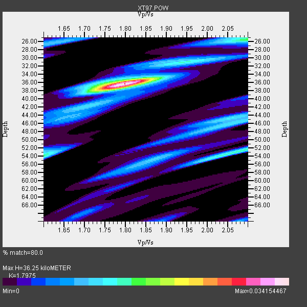
| Thickness Estimate: | 36 km |
| Thickness StdDev: | 8.7 km |
| Vp/Vs Estimate: | 1.80 |
| Vp/Vs StdDev: | 0.10 |
| Vs Estimate: | 3.453 km/s |
| Poisson's Ratio: | 0.28 |
| Peak Value: | 0.03 |
| Assumed Vp: | 6.207 km/s |
| Ps Weight: | 0.33333334 |
| PpPs Weight: | 0.33333334 |
| PsPs Weight: | 0.33333328 |
| Residual Complexity: | 0.587 |
| Nearby stations H: | +- |
| (2.0 deg) Vp/Vs: | +- |
2 with match > 90% ( 5.882353 %) and 6 with match > 80% ( 17.647058 %) out of 34.
Download stack as xyz text file.
Azimuth Distribution of Events:

Prior Results for this Station
| Study | Thickness | Vp/Vs | Vp | Vs | Poissons Ratio | Extra |
| EARS | 36 km | 1.80 | 6.207 km/s | 3.453 km/s | 0.28 | |
| Crust2.0 | 43 km | 1.76 | 6.207 km/s | 3.535 km/s | 0.26 | Q4,orogen/43km no ice, Tethian Belt, 5 km seds. |
| Global Maxima | 36 km | 1.80 | 6.207 km/s | 3.453 km/s | 0.28 | amp=0.034154467 |
| Local Maxima 1 | 26 km | 2.10 | 6.207 km/s | 2.959 km/s | 0.35 | amp=0.01598338 |
| Local Maxima 2 | 54 km | 1.60 | 6.207 km/s | 3.879 km/s | 0.18 | amp=0.015617348 |
| Local Maxima 3 | 53 km | 2.08 | 6.207 km/s | 2.991 km/s | 0.35 | amp=0.014576238 |
| Local Maxima 4 | 44 km | 2.06 | 6.207 km/s | 3.013 km/s | 0.35 | amp=0.011578754 |
| Predicted Arrivals for vertical incidence (zero ray parameter) | |
| Ps | 4.66 SECOND |
| PpPs | 16.34 SECOND |
| PsPs/PpSs | 21.00 SECOND |
Events Processed for this Station
Download zip of receiver functions as SAC
Plot maxima for each earthquake.
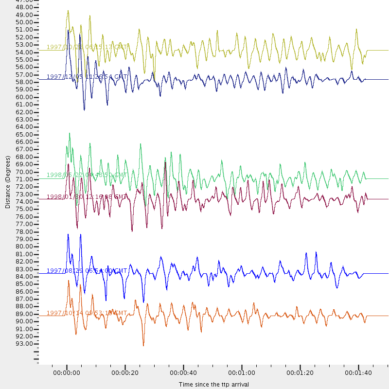
Events Used in the Stack
(6 events)| Radial Match | Distance | Baz | FERegion | Time | Lat/Lon | Depth | Magnitude |
| 93.3897 | 89.1 deg | 239.551 deg | South Of Fiji Islands | 1997/10/14 09:53:18 GMT | (-22.1, -176.8) | 167 km | 6.7 MB, 7.7 UNKNOWN, 7.4 ME |
| 92.97494 | 57.6 deg | 316.756 deg | Near East Coast Of Kamchatka | 1997/12/05 11:26:54 GMT | (54.8, 162.0) | 33 km | 6.3 MB, 7.6 MS, 7.9 UNKNOWN, 7.3 ME |
| 87.03013 | 83.5 deg | 243.555 deg | Tonga Islands | 1997/08/29 06:54:00 GMT | (-15.2, -175.6) | 33 km | 5.6 MB, 6.4 MS, 6.5 UNKNOWN, 6.4 MW |
| 82.56657 | 53.6 deg | 139.344 deg | Northern Peru | 1997/10/28 06:15:17 GMT | (-4.4, -76.7) | 112 km | 6.6 MB, 6.3 MS, 7.2 UNKNOWN, 6.6 ME |
| 82.51197 | 70.7 deg | 136.48 deg | Central Bolivia | 1998/05/22 04:48:50 GMT | (-17.7, -65.4) | 24 km | 5.9 MB, 6.6 MS, 6.6 UNKNOWN, 6.2 ME |
| 82.31358 | 73.6 deg | 143.842 deg | Near Coast Of Northern Chile | 1998/01/30 12:16:08 GMT | (-23.9, -70.2) | 42 km | 6.3 MB, 6.5 MS, 7.0 UNKNOWN, 6.7 ME |
Losers
(28 events)| Radial Match | Distance | Baz | FERegion | Time | Lat/Lon | Depth | Magnitude | Reason |
| 99.15532 | 87.5 deg | 244.304 deg | Fiji Islands Region | 1998/03/29 19:48:16 GMT | (-17.6, -179.1) | 537 km | 6.5 MB, 7.2 UNKNOWN, 7.1 MW | |
| 98.04103 | 81.3 deg | 145.794 deg | San Juan Province, Argentina | 1998/06/07 16:10:46 GMT | (-31.5, -67.8) | 113 km | 5.6 MB, 5.9 UNKNOWN, 5.9 MW | |
| 82.052246 | 45.2 deg | 176.169 deg | Central East Pacific Rise | 1997/08/15 07:37:49 GMT | (-4.4, -105.7) | 10 km | 5.3 MB, 5.8 MS, 6.2 UNKNOWN, 6.1 MW | |
| 80.6342 | 79.4 deg | 148.087 deg | Near Coast Of Central Chile | 1997/10/15 01:03:33 GMT | (-30.9, -71.2) | 58 km | 6.8 MB, 6.8 MS, 7.3 UNKNOWN, 7.1 MW | |
| 79.649765 | 86.4 deg | 154.953 deg | Off Coast Of Southern Chile | 1998/04/01 22:42:56 GMT | (-40.3, -74.9) | 9.0 km | 6.2 MB, 6.0 MS, 6.7 UNKNOWN, 6.6 ME | |
| 79.281395 | 89.8 deg | 237.911 deg | South Of Fiji Islands | 1998/04/11 01:10:51 GMT | (-23.7, -176.0) | 33 km | 5.2 MB, 5.5 MS | |
| 77.67389 | 58.3 deg | 315.921 deg | Off East Coast Of Kamchatka | 1997/12/05 11:35:19 GMT | (53.9, 161.6) | 33 km | 5.7 MB | |
| 76.54505 | 59.5 deg | 315.348 deg | Off East Coast Of Kamchatka | 1998/06/01 05:34:03 GMT | (52.9, 160.1) | 44 km | 6.2 MB, 6.3 MS, 6.5 UNKNOWN, 6.4 MW | |
| 75.79258 | 30.3 deg | 145.958 deg | Guatemala | 1998/01/10 08:20:05 GMT | (14.4, -91.5) | 33 km | 6.1 MB, 6.2 MS, 6.6 UNKNOWN, 6.6 ME | |
| 75.48916 | 31.2 deg | 145.319 deg | Near Coast Of Guatemala | 1998/05/10 06:05:58 GMT | (13.7, -90.7) | 33 km | 5.3 MB, 5.9 MS, 6.3 UNKNOWN, 5.3 MD | |
| 72.56456 | 79.3 deg | 148.258 deg | Near Coast Of Central Chile | 1998/01/12 10:14:07 GMT | (-31.0, -71.4) | 35 km | 5.8 MB, 6.2 MS, 6.6 UNKNOWN, 6.2 ME | |
| 69.68752 | 47.2 deg | 132.737 deg | Colombia | 1997/09/02 12:13:22 GMT | (3.8, -75.7) | 199 km | 6.5 MB, 6.8 UNKNOWN, 6.4 ME | |
| 69.624084 | 47.1 deg | 132.719 deg | Colombia | 1997/12/11 07:56:28 GMT | (3.9, -75.8) | 178 km | 6.0 MB, 6.4 UNKNOWN, 6.3 MW | |
| 67.810455 | 30.2 deg | 147.552 deg | Near Coast Of Chiapas, Mexico | 1997/12/25 22:16:19 GMT | (14.1, -92.3) | 10 km | 5.4 MB, 5.3 MS, 5.8 UNKNOWN, 5.5 MD | |
| 67.63068 | 98.2 deg | 264.788 deg | Solomon Islands | 1997/10/10 18:45:52 GMT | (-9.3, 158.7) | 33 km | 5.4 MB, 5.7 MS, 6.0 UNKNOWN, 5.8 MW | |
| 66.52991 | 91.0 deg | 241.253 deg | South Of Fiji Islands | 1998/05/16 02:22:03 GMT | (-22.2, -179.5) | 586 km | 6.1 MB, 6.8 UNKNOWN | |
| 65.26068 | 65.6 deg | 137.11 deg | Peru-Bolivia Border Region | 1997/11/28 22:53:41 GMT | (-13.7, -68.8) | 586 km | 6.4 MB, 6.6 UNKNOWN, 6.6 MW | |
| 64.71762 | 30.3 deg | 145.94 deg | Guatemala | 1998/03/03 02:24:43 GMT | (14.4, -91.5) | 63 km | 5.5 MB, 5.4 MS, 6.2 UNKNOWN, 6.1 MW | |
| 64.38628 | 88.9 deg | 241.128 deg | Fiji Islands Region | 1997/08/25 11:59:00 GMT | (-20.8, -177.8) | 394 km | 5.5 UNKNOWN, 5.3 MB | |
| 62.834923 | 83.9 deg | 309.532 deg | Southeast Of Honshu, Japan | 1998/02/28 17:38:48 GMT | (33.5, 138.1) | 291 km | 5.7 UNKNOWN, 5.3 MB, 5.7 MW | |
| 62.764374 | 63.0 deg | 318.431 deg | Sea Of Okhotsk | 1997/12/20 13:26:31 GMT | (53.4, 152.8) | 614 km | 5.9 UNKNOWN, 5.1 MB, 5.9 MW | |
| 62.438587 | 95.4 deg | 239.478 deg | South Of Fiji Islands | 1997/09/04 04:23:37 GMT | (-26.6, 178.3) | 625 km | 6.3 MB, 6.8 UNKNOWN, 6.5 ME | |
| 60.27244 | 76.2 deg | 311.586 deg | Off East Coast Of Honshu, Japan | 1998/05/14 18:56:23 GMT | (40.3, 143.3) | 33 km | 5.8 MB, 5.7 MS, 5.9 UNKNOWN | |
| 59.35824 | 32.0 deg | 141.875 deg | El Salvador | 1997/12/18 15:02:00 GMT | (13.8, -88.7) | 182 km | 5.3 MB, 6.1 UNKNOWN, 6.0 MW | |
| 57.148106 | 60.4 deg | 140.874 deg | Central Peru | 1998/02/19 04:21:30 GMT | (-11.0, -74.4) | 33 km | 5.8 MB, 5.4 MS, 6.0 UNKNOWN, 5.9 MW | |
| 56.44552 | 60.1 deg | 314.873 deg | Off East Coast Of Kamchatka | 1998/05/27 20:41:37 GMT | (52.2, 159.5) | 60 km | 5.5 MB, 6.0 UNKNOWN, 5.9 MW | |
| 46.407383 | 71.7 deg | 313.598 deg | Kuril Islands | 1997/10/22 09:55:47 GMT | (44.7, 146.2) | 154 km | 5.5 MB, 5.6 UNKNOWN, 5.6 MW | |
| 42.856205 | 85.0 deg | 40.517 deg | Southern Italy | 1998/05/18 17:19:04 GMT | (39.3, 15.1) | 280 km | 5.6 MB |
