
Station XT VMSC - XT.VMSC
Network: XT97 - Colorado BB Array - Lodore
Nearby stations (2 deg radius)
| Station | Name | (Lat, Lon) | Start / End | Elevation |
| VMSC | XT.VMSC | (40.93, -108.65) | 1997-08-01 / 1998-07-15 | 2006 m |
| Crust2 Type: | Q4,orogen/43km no ice, Tethian Belt, 5 km seds. |
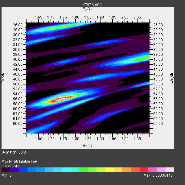
| Thickness Estimate: | 56 km |
| Thickness StdDev: | 9.7 km |
| Vp/Vs Estimate: | 1.75 |
| Vp/Vs StdDev: | 0.07 |
| Vs Estimate: | 3.557 km/s |
| Poisson's Ratio: | 0.26 |
| Peak Value: | 0.03 |
| Assumed Vp: | 6.207 km/s |
| Ps Weight: | 0.33333334 |
| PpPs Weight: | 0.33333334 |
| PsPs Weight: | 0.33333328 |
| Residual Complexity: | 0.672 |
| Nearby stations H: | +- |
| (2.0 deg) Vp/Vs: | +- |
4 with match > 90% ( 10.0 %) and 10 with match > 80% ( 25.0 %) out of 40.
Download stack as xyz text file.
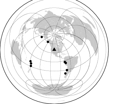
Azimuth Distribution of Events:
Prior Results for this Station
| Study | Thickness | Vp/Vs | Vp | Vs | Poissons Ratio | Extra |
| EARS | 56 km | 1.75 | 6.207 km/s | 3.557 km/s | 0.26 | |
| Crust2.0 | 43 km | 1.76 | 6.207 km/s | 3.535 km/s | 0.26 | Q4,orogen/43km no ice, Tethian Belt, 5 km seds. |
| Global Maxima | 56 km | 1.75 | 6.207 km/s | 3.557 km/s | 0.26 | amp=0.03035448 |
| Local Maxima 1 | 27 km | 1.74 | 6.207 km/s | 3.578 km/s | 0.25 | amp=0.016595833 |
| Local Maxima 2 | 40 km | 2.09 | 6.207 km/s | 2.966 km/s | 0.35 | amp=0.015263415 |
| Local Maxima 3 | 57 km | 1.82 | 6.207 km/s | 3.415 km/s | 0.28 | amp=0.013083843 |
| Local Maxima 4 | 56 km | 1.71 | 6.207 km/s | 3.635 km/s | 0.24 | amp=0.009205652 |
| Predicted Arrivals for vertical incidence (zero ray parameter) | |
| Ps | 6.72 SECOND |
| PpPs | 24.77 SECOND |
| PsPs/PpSs | 31.49 SECOND |
Events Processed for this Station
Download zip of receiver functions as SAC
Plot maxima for each earthquake.
Events Used in the Stack
(10 events)| Radial Match | Distance | Baz | FERegion | Time | Lat/Lon | Depth | Magnitude |
| 95.44788 | 89.0 deg | 239.401 deg | South Of Fiji Islands | 1997/10/14 09:53:18 GMT | (-22.1, -176.8) | 167 km | 6.7 MB, 7.7 UNKNOWN, 7.4 ME |
| 92.97958 | 87.3 deg | 244.152 deg | Fiji Islands Region | 1998/03/29 19:48:16 GMT | (-17.6, -179.1) | 537 km | 6.5 MB, 7.2 UNKNOWN, 7.1 MW |
| 91.9227 | 86.5 deg | 154.794 deg | Off Coast Of Southern Chile | 1998/04/01 22:42:56 GMT | (-40.3, -74.9) | 9.0 km | 6.2 MB, 6.0 MS, 6.7 UNKNOWN, 6.6 ME |
| 91.693375 | 53.7 deg | 139.096 deg | Northern Peru | 1997/10/28 06:15:17 GMT | (-4.4, -76.7) | 112 km | 6.6 MB, 6.3 MS, 7.2 UNKNOWN, 6.6 ME |
| 88.21901 | 79.4 deg | 147.911 deg | Near Coast Of Central Chile | 1997/10/15 01:03:33 GMT | (-30.9, -71.2) | 58 km | 6.8 MB, 6.8 MS, 7.3 UNKNOWN, 7.1 MW |
| 87.58342 | 59.4 deg | 315.275 deg | Off East Coast Of Kamchatka | 1998/06/01 05:34:03 GMT | (52.9, 160.1) | 44 km | 6.2 MB, 6.3 MS, 6.5 UNKNOWN, 6.4 MW |
| 86.22534 | 33.5 deg | 321.011 deg | Southern Alaska | 1998/07/09 19:39:43 GMT | (60.5, -153.2) | 145 km | 5.3 MB, 6.2 UNKNOWN, 6.2 MW |
| 84.691696 | 58.2 deg | 138.828 deg | Peru-Brazil Border Region | 1998/04/03 22:01:48 GMT | (-8.1, -74.2) | 165 km | 6.1 MB, 5.6 MS, 6.6 UNKNOWN, 6.6 MW |
| 83.33154 | 94.2 deg | 235.318 deg | Kermadec Islands Region | 1997/09/20 16:11:32 GMT | (-28.7, -177.6) | 30 km | 6.1 MB, 7.0 MS, 7.2 UNKNOWN, 6.7 ME |
| 81.66866 | 79.4 deg | 148.082 deg | Near Coast Of Central Chile | 1998/01/12 10:14:07 GMT | (-31.0, -71.4) | 35 km | 5.8 MB, 6.2 MS, 6.6 UNKNOWN, 6.2 ME |
Losers
(30 events)| Radial Match | Distance | Baz | FERegion | Time | Lat/Lon | Depth | Magnitude | Reason |
| 85.95194 | 73.7 deg | 143.652 deg | Near Coast Of Northern Chile | 1998/01/30 12:16:08 GMT | (-23.9, -70.2) | 42 km | 6.3 MB, 6.5 MS, 7.0 UNKNOWN, 6.7 ME | |
| 84.96971 | 90.9 deg | 241.106 deg | South Of Fiji Islands | 1998/05/16 02:22:03 GMT | (-22.2, -179.5) | 586 km | 6.1 MB, 6.8 UNKNOWN | |
| 79.91237 | 30.4 deg | 145.56 deg | Guatemala | 1998/01/10 08:20:05 GMT | (14.4, -91.5) | 33 km | 6.1 MB, 6.2 MS, 6.6 UNKNOWN, 6.6 ME | |
| 79.415535 | 96.3 deg | 234.87 deg | Kermadec Islands, New Zealand | 1998/07/09 14:45:39 GMT | (-30.5, -179.0) | 130 km | 6.2 MB, 6.2 MS, 6.9 UNKNOWN, 6.4 ME | |
| 76.88678 | 49.4 deg | 307.781 deg | Rat Islands, Aleutian Islands | 1997/12/17 04:38:51 GMT | (51.2, 178.9) | 20 km | 5.8 MB, 6.5 MS, 6.7 UNKNOWN, 6.1 ME | |
| 73.13315 | 90.8 deg | 37.712 deg | Southern Greece | 1997/10/13 13:39:37 GMT | (36.4, 22.1) | 24 km | 6.2 MB, 6.6 MS, 6.7 UNKNOWN, 6.5 MW | |
| 72.39244 | 58.2 deg | 315.852 deg | Off East Coast Of Kamchatka | 1997/12/05 11:35:19 GMT | (53.9, 161.6) | 33 km | 5.7 MB | |
| 72.02225 | 30.3 deg | 147.148 deg | Near Coast Of Chiapas, Mexico | 1997/12/25 22:16:19 GMT | (14.1, -92.3) | 10 km | 5.4 MB, 5.3 MS, 5.8 UNKNOWN, 5.5 MD | |
| 71.86003 | 86.9 deg | 238.333 deg | Tonga Islands | 1997/09/10 12:57:07 GMT | (-21.3, -174.4) | 10 km | 5.7 MB, 6.1 MS, 6.1 UNKNOWN, 5.9 MW | |
| 69.43423 | 41.6 deg | 306.901 deg | Fox Islands, Aleutian Islands | 1998/01/23 09:20:08 GMT | (52.4, -168.6) | 33 km | 5.8 MB, 5.5 MS, 5.8 UNKNOWN, 5.5 ML | |
| 69.01424 | 30.4 deg | 145.542 deg | Guatemala | 1998/03/03 02:24:43 GMT | (14.4, -91.5) | 63 km | 5.5 MB, 5.4 MS, 6.2 UNKNOWN, 6.1 MW | |
| 65.653465 | 65.7 deg | 136.903 deg | Peru-Bolivia Border Region | 1997/11/28 22:53:41 GMT | (-13.7, -68.8) | 586 km | 6.4 MB, 6.6 UNKNOWN, 6.6 MW | |
| 65.24592 | 78.3 deg | 312.251 deg | Eastern Honshu, Japan | 1997/10/26 19:06:44 GMT | (39.3, 140.5) | 134 km | 5.6 UNKNOWN, 5.2 MB | |
| 64.71387 | 31.3 deg | 144.932 deg | Near Coast Of Guatemala | 1998/05/10 06:05:58 GMT | (13.7, -90.7) | 33 km | 5.3 MB, 5.9 MS, 6.3 UNKNOWN, 5.3 MD | |
| 64.54139 | 32.1 deg | 141.504 deg | El Salvador | 1997/12/18 15:02:00 GMT | (13.8, -88.7) | 182 km | 5.3 MB, 6.1 UNKNOWN, 6.0 MW | |
| 64.084816 | 79.8 deg | 310.305 deg | Near East Coast Of Honshu, Japan | 1998/04/09 08:45:40 GMT | (36.9, 140.8) | 111 km | 5.6 UNKNOWN, 5.3 MB, 5.5 MW | |
| 61.711468 | 47.2 deg | 132.458 deg | Colombia | 1997/12/11 07:56:28 GMT | (3.9, -75.8) | 178 km | 6.0 MB, 6.4 UNKNOWN, 6.3 MW | |
| 60.878216 | 81.0 deg | 309.352 deg | Near East Coast Of Honshu, Japan | 1998/06/14 13:17:08 GMT | (35.4, 140.5) | 45 km | 5.5 MB, 5.3 MS, 5.8 UNKNOWN, 5.8 MW | |
| 60.26206 | 92.6 deg | 291.9 deg | Mariana Islands | 1997/12/18 20:23:02 GMT | (14.7, 144.7) | 33 km | 5.5 MB, 5.4 MS, 5.9 UNKNOWN, 5.8 MW | |
| 58.83845 | 92.2 deg | 240.194 deg | South Of Fiji Islands | 1998/04/14 03:41:22 GMT | (-23.8, -179.9) | 499 km | 5.5 MB, 6.2 UNKNOWN, 6.1 MW | |
| 58.540485 | 83.8 deg | 309.397 deg | Southeast Of Honshu, Japan | 1998/02/28 17:38:48 GMT | (33.5, 138.1) | 291 km | 5.7 UNKNOWN, 5.3 MB, 5.7 MW | |
| 57.421143 | 60.5 deg | 140.648 deg | Central Peru | 1998/02/19 04:21:30 GMT | (-11.0, -74.4) | 33 km | 5.8 MB, 5.4 MS, 6.0 UNKNOWN, 5.9 MW | |
| 55.37356 | 89.5 deg | 241.615 deg | Fiji Islands Region | 1997/10/17 15:02:00 GMT | (-20.9, -178.8) | 579 km | 5.3 MB, 6.0 UNKNOWN, 6.0 MW | |
| 53.76552 | 85.2 deg | 40.379 deg | Southern Italy | 1998/05/18 17:19:04 GMT | (39.3, 15.1) | 280 km | 5.6 MB | |
| 52.806297 | 71.5 deg | 313.491 deg | Kuril Islands | 1997/10/22 09:55:47 GMT | (44.7, 146.2) | 154 km | 5.5 MB, 5.6 UNKNOWN, 5.6 MW | |
| 51.30905 | 96.1 deg | 234.346 deg | Kermadec Islands, New Zealand | 1997/10/27 09:32:59 GMT | (-30.8, -178.5) | 33 km | 5.5 MB, 5.4 MS | |
| 50.911713 | 76.0 deg | 313.035 deg | Hokkaido, Japan Region | 1998/01/30 15:50:13 GMT | (41.5, 142.0) | 33 km | 5.6 MB, 5.1 MS | |
| 41.857178 | 81.4 deg | 145.624 deg | San Juan Province, Argentina | 1998/06/07 16:10:46 GMT | (-31.5, -67.8) | 113 km | 5.6 MB, 5.9 UNKNOWN, 5.9 MW | |
| 41.67871 | 92.8 deg | 291.367 deg | Mariana Islands | 1998/05/15 05:58:06 GMT | (14.2, 144.9) | 154 km | 5.7 MB, 6.0 UNKNOWN, 6.0 MW | |
| 27.678236 | 95.4 deg | 234.494 deg | Kermadec Islands, New Zealand | 1998/06/20 20:24:45 GMT | (-30.1, -177.9) | 57 km | 5.7 MB, 6.0 UNKNOWN, 6.0 MW |
