
Station XU QRZA - Quartz Hills
Network: XU96 - New Zealand Seismic Experiment
Nearby stations (2 deg radius)
| Station | Name | (Lat, Lon) | Start / End | Elevation |
| QRZA | Quartz Hills | (-40.83, 172.53) | 1996-04-09 / 1997-12-31 | 294 m |
| Crust2 Type: | K1,forearc, New Zealand, 2 km seds. |
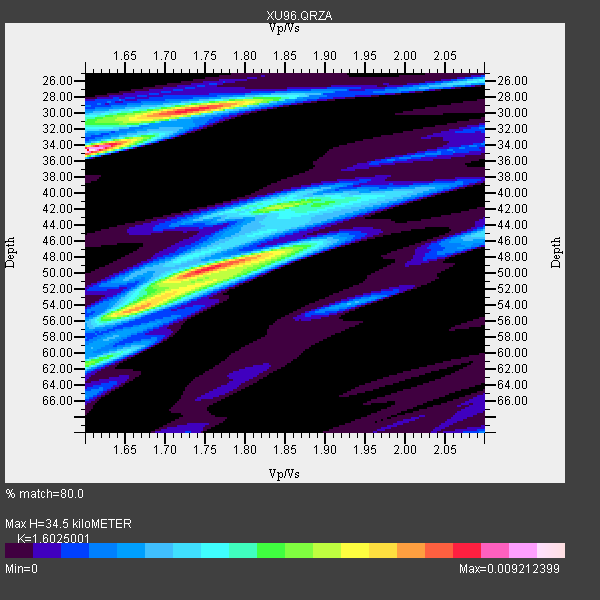
| Thickness Estimate: | 34 km |
| Thickness StdDev: | 9.5 km |
| Vp/Vs Estimate: | 1.60 |
| Vp/Vs StdDev: | 0.10 |
| Vs Estimate: | 3.924 km/s |
| Poisson's Ratio: | 0.18 |
| Peak Value: | 0.01 |
| Assumed Vp: | 6.289 km/s |
| Ps Weight: | 0.33333334 |
| PpPs Weight: | 0.33333334 |
| PsPs Weight: | 0.33333328 |
| Residual Complexity: | 0.919 |
| Nearby stations H: | 48 km +- 19 km |
| (2.0 deg) Vp/Vs: | 1.61 +- 0.01 |
0 with match > 90% ( 0.0 %) and 7 with match > 80% ( 36.842106 %) out of 19.
Download stack as xyz text file.
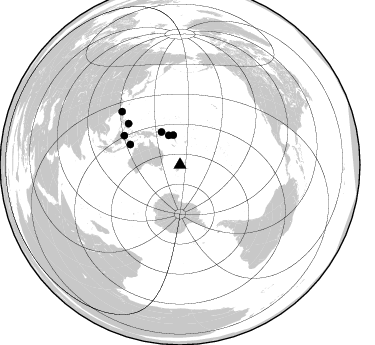
Azimuth Distribution of Events:
Prior Results for this Station
| Study | Thickness | Vp/Vs | Vp | Vs | Poissons Ratio | Extra |
| EARS | 34 km | 1.60 | 6.289 km/s | 3.924 km/s | 0.18 | |
| Crust2.0 | 35 km | 1.76 | 6.289 km/s | 3.569 km/s | 0.26 | K1,forearc, New Zealand, 2 km seds. |
| Global Maxima | 34 km | 1.60 | 6.289 km/s | 3.924 km/s | 0.18 | amp=0.009212399 |
| Local Maxima 1 | 50 km | 1.75 | 6.289 km/s | 3.599 km/s | 0.26 | amp=0.0075992844 |
| Local Maxima 2 | 30 km | 1.74 | 6.289 km/s | 3.625 km/s | 0.25 | amp=0.0069150887 |
| Local Maxima 3 | 54 km | 1.66 | 6.289 km/s | 3.788 km/s | 0.22 | amp=0.0060850936 |
| Local Maxima 4 | 42 km | 1.83 | 6.289 km/s | 3.441 km/s | 0.29 | amp=0.004237116 |
| Predicted Arrivals for vertical incidence (zero ray parameter) | |
| Ps | 3.31 SECOND |
| PpPs | 14.28 SECOND |
| PsPs/PpSs | 17.58 SECOND |
Events Processed for this Station
Download zip of receiver functions as SAC
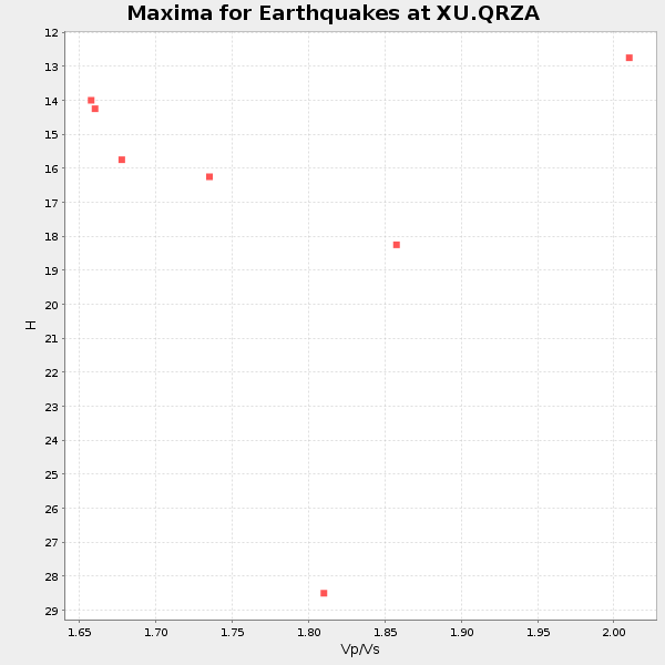
Plot maxima for each earthquake.
Events Used in the Stack
(7 events)| Radial Match | Distance | Baz | FERegion | Time | Lat/Lon | Depth | Magnitude |
| 88.86229 | 31.5 deg | 338.801 deg | Solomon Islands | 1996/08/02 12:55:29 GMT | (-10.8, 161.4) | 33 km | 6.2 MB, 7.1 MS, 6.9 UNKNOWN, 6.9 MW |
| 88.01205 | 65.7 deg | 308.571 deg | Mindanao, Philippines | 1996/09/20 04:10:27 GMT | (9.5, 126.3) | 33 km | 5.8 MB, 6.4 MS, 6.6 UNKNOWN, 6.6 MW |
| 87.45166 | 37.6 deg | 330.613 deg | Solomon Islands | 1996/04/29 14:40:41 GMT | (-6.5, 155.0) | 44 km | 6.3 MB, 7.5 MS, 7.2 UNKNOWN, 6.8 ME |
| 86.968216 | 62.9 deg | 297.655 deg | Minahassa Peninsula, Sulawesi | 1996/07/22 14:19:35 GMT | (1.0, 120.4) | 33 km | 6.0 MB, 6.9 MS, 7.0 UNKNOWN, 6.9 MW |
| 81.26327 | 53.7 deg | 292.291 deg | Flores Region, Indonesia | 1997/01/17 11:20:22 GMT | (-8.9, 123.5) | 111 km | 6.2 MB, 6.2 UNKNOWN, 6.2 MW |
| 81.128845 | 78.4 deg | 312.504 deg | Taiwan Region | 1996/09/05 23:42:06 GMT | (21.9, 121.5) | 20 km | 6.4 MB, 6.6 MS, 6.8 UNKNOWN, 6.8 ME |
| 80.46274 | 30.4 deg | 347.222 deg | Santa Cruz Islands | 1996/09/14 13:10:53 GMT | (-10.9, 166.0) | 73 km | 6.0 MB, 6.0 MS, 6.4 UNKNOWN, 6.4 MW |
Losers
(12 events)| Radial Match | Distance | Baz | FERegion | Time | Lat/Lon | Depth | Magnitude | Reason |
| 95.13739 | 58.7 deg | 302.179 deg | Northern Molucca Sea | 1996/10/18 11:19:18 GMT | (0.4, 126.2) | 44 km | 5.6 MB, 6.3 MS | |
| 74.251854 | 41.8 deg | 318.526 deg | Eastern New Guinea Reg., P.N.G. | 1996/09/21 01:23:33 GMT | (-6.2, 146.2) | 10 km | 5.7 MB, 5.8 MS, 5.9 UNKNOWN | |
| 70.32506 | 89.0 deg | 336.122 deg | Eastern Sea Of Japan | 1996/12/22 14:53:27 GMT | (43.2, 138.9) | 227 km | 6.0 MB, 6.5 UNKNOWN, 6.5 MW | |
| 68.180984 | 97.4 deg | 127.277 deg | Southern Bolivia | 1997/01/23 02:15:22 GMT | (-22.0, -65.7) | 276 km | 6.4 MB, 7.1 UNKNOWN, 7.1 MW | |
| 65.79432 | 48.9 deg | 312.84 deg | Irian Jaya, Indonesia | 1996/12/26 20:48:23 GMT | (-2.2, 138.9) | 33 km | 6.0 MB, 6.1 MS, 6.3 UNKNOWN, 6.1 MW | |
| 59.74783 | 34.4 deg | 335.741 deg | Solomon Islands | 1997/02/08 01:55:55 GMT | (-8.5, 159.0) | 101 km | 5.8 MB, 5.8 UNKNOWN, 5.7 MW | |
| 58.035683 | 65.8 deg | 308.859 deg | Mindanao, Philippines | 1996/11/04 12:53:36 GMT | (9.7, 126.4) | 33 km | 5.5 MS, 5.4 MB, 5.9 UNKNOWN, 5.8 MW | |
| 57.620026 | 44.1 deg | 320.72 deg | Bismarck Sea | 1996/09/16 05:47:32 GMT | (-3.4, 146.4) | 33 km | 5.5 MB, 5.8 MS, 5.9 UNKNOWN, 5.9 MW | |
| 56.5916 | 96.1 deg | 115.422 deg | Near Coast Of Peru | 1996/11/13 02:41:39 GMT | (-14.8, -75.7) | 33 km | 5.6 MB, 5.8 MS, 6.0 UNKNOWN, 6.0 MW | |
| 52.701275 | 68.3 deg | 330.332 deg | Mariana Islands Region | 1996/07/06 21:36:28 GMT | (22.0, 142.8) | 241 km | 5.8 MB, 6.3 UNKNOWN, 6.2 MW | |
| 52.13692 | 65.9 deg | 235.319 deg | Mid-Indian Ridge | 1996/08/19 06:24:11 GMT | (-41.5, 80.4) | 10 km | 5.4 MB, 5.9 MS, 6.0 UNKNOWN, 5.9 MW | |
| 44.736687 | 86.5 deg | 129.963 deg | Near Coast Of Central Chile | 1996/09/09 00:20:39 GMT | (-31.9, -71.6) | 39 km | 6.0 MB, 5.5 MS, 6.0 UNKNOWN, 5.8 ME |
