
Station XW CHAT - XW.CHAT
Network: XW97 - Tien Shan Continental Dynamics
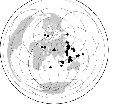
Nearby stations (2 deg radius)
| Station | Name | (Lat, Lon) | Start / End | Elevation |
| CHAT | XW.CHAT | (40.92, 76.52) | 1999-07-14 / 2002-01-01 | 3031 m |
| Crust2 Type: | R4,orogen/55km Tibet Transition, 0 km seds. |
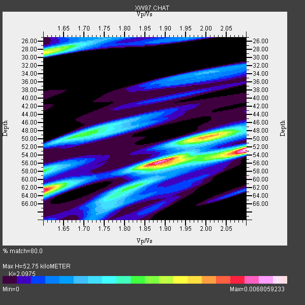
| Thickness Estimate: | 53 km |
| Thickness StdDev: | 6.1 km |
| Vp/Vs Estimate: | 2.10 |
| Vp/Vs StdDev: | 0.20 |
| Vs Estimate: | 3.095 km/s |
| Poisson's Ratio: | 0.35 |
| Peak Value: | 0.01 |
| Assumed Vp: | 6.491 km/s |
| Ps Weight: | 0.33333334 |
| PpPs Weight: | 0.33333334 |
| PsPs Weight: | 0.33333328 |
| Residual Complexity: | 0.865 |
| Nearby stations H: | +- |
| (2.0 deg) Vp/Vs: | +- |
34 with match > 90% ( 62.962963 %) and 54 with match > 80% ( 100.0 %) out of 54.
Download stack as xyz text file.
Azimuth Distribution of Events:
Prior Results for this Station
| Study | Thickness | Vp/Vs | Vp | Vs | Poissons Ratio | Extra |
| EARS | 53 km | 2.10 | 6.491 km/s | 3.095 km/s | 0.35 | |
| Crust2.0 | 55 km | 1.76 | 6.491 km/s | 3.696 km/s | 0.26 | R4,orogen/55km Tibet Transition, 0 km seds. |
| Global Maxima | 53 km | 2.10 | 6.491 km/s | 3.095 km/s | 0.35 | amp=0.0068059233 |
| Local Maxima 1 | 55 km | 1.89 | 6.491 km/s | 3.425 km/s | 0.31 | amp=0.005800721 |
| Local Maxima 2 | 62 km | 1.60 | 6.491 km/s | 4.057 km/s | 0.18 | amp=0.0050018597 |
| Local Maxima 3 | 29 km | 1.60 | 6.491 km/s | 4.057 km/s | 0.18 | amp=0.004412746 |
| Local Maxima 4 | 49 km | 2.01 | 6.491 km/s | 3.233 km/s | 0.33 | amp=0.0039505977 |
| Predicted Arrivals for vertical incidence (zero ray parameter) | |
| Ps | 8.92 SECOND |
| PpPs | 25.17 SECOND |
| PsPs/PpSs | 34.09 SECOND |
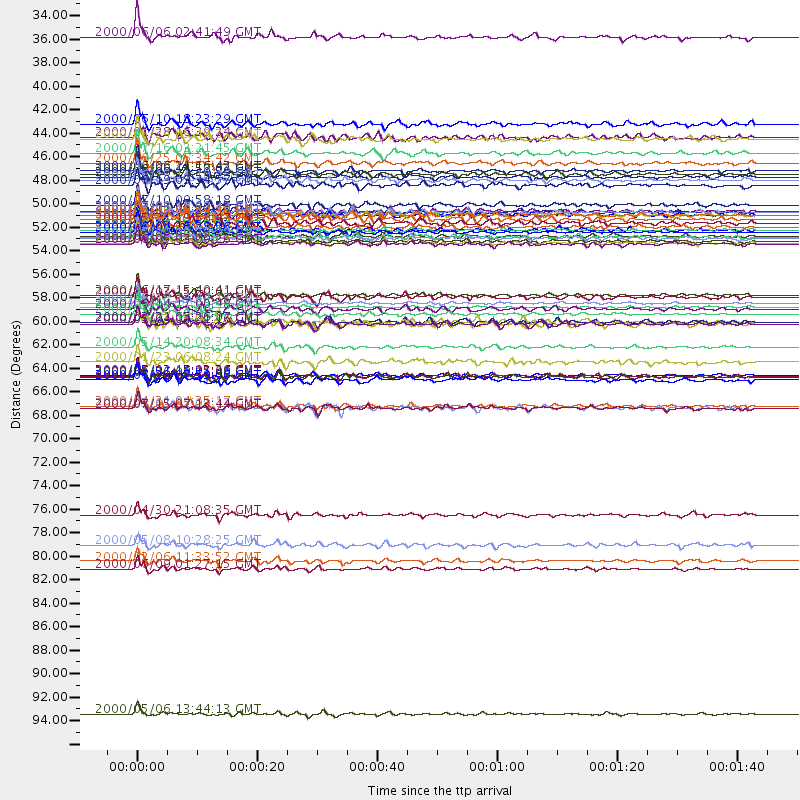
Events Processed for this Station
Download zip of receiver functions as SAC
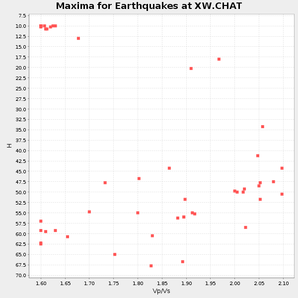
Plot maxima for each earthquake.
Events Used in the Stack
(54 events)| Radial Match | Distance | Baz | FERegion | Time | Lat/Lon | Depth | Magnitude |
| 97.750275 | 51.1 deg | 146.449 deg | Southern Sumatra, Indonesia | 2000/06/04 16:28:26 GMT | (-4.7, 102.1) | 33 km | 6.8 MB, 8.0 MS, 7.9 MW, 7.7 MW |
| 97.58598 | 57.8 deg | 155.783 deg | South Indian Ocean | 2000/06/18 14:44:13 GMT | (-13.8, 97.5) | 10 km | 6.8 MB, 7.8 MS, 7.8 MW, 7.6 MW |
| 97.51365 | 58.8 deg | 86.489 deg | Volcano Islands, Japan Region | 2000/03/28 11:00:22 GMT | (22.3, 143.7) | 126 km | 6.8 MB, 7.6 MS, 7.6 MW, 7.6 MW |
| 96.68547 | 50.9 deg | 62.828 deg | Kuril Islands | 2000/01/28 14:21:07 GMT | (43.0, 146.8) | 61 km | 6.7 MB, 6.6 MS, 6.8 MW, 6.8 ME |
| 96.13123 | 50.9 deg | 146.602 deg | Southern Sumatra, Indonesia | 2000/06/07 23:45:26 GMT | (-4.6, 101.9) | 33 km | 6.1 MB, 6.7 MS, 6.7 MW, 6.5 MW |
| 96.05914 | 58.1 deg | 155.762 deg | South Indian Ocean | 2000/06/20 11:34:00 GMT | (-14.1, 97.6) | 10 km | 5.6 MB, 5.6 MS, 6.1 MW, 5.8 MW |
| 95.24929 | 49.5 deg | 72.996 deg | Near East Coast Of Honshu, Japan | 2000/07/20 18:39:18 GMT | (36.5, 141.0) | 47 km | 6.1 MB, 5.4 MS, 6.1 ME, 6.0 MW |
| 95.237816 | 45.9 deg | 149.369 deg | Southwest Of Sumatra, Indonesia | 2000/05/08 12:29:59 GMT | (-0.8, 98.0) | 33 km | 5.6 MB, 5.3 MS, 5.9 MW, 5.6 MW |
| 95.10689 | 52.1 deg | 146.21 deg | Southern Sumatra, Indonesia | 2000/06/09 08:00:24 GMT | (-5.5, 102.7) | 33 km | 5.8 MB, 5.8 MS, 6.0 MW, 6.0 MW |
| 94.94555 | 49.1 deg | 76.583 deg | Near S. Coast Of Honshu, Japan | 2000/07/01 07:01:55 GMT | (34.2, 139.1) | 10 km | 6.0 MB, 6.1 MS, 6.2 MW, 6.2 MW |
| 94.79329 | 49.5 deg | 74.369 deg | Near East Coast Of Honshu, Japan | 2000/06/03 08:54:49 GMT | (35.6, 140.5) | 62 km | 5.6 MB, 5.6 MS, 6.1 MW, 6.1 MW |
| 94.23574 | 49.5 deg | 76.834 deg | Southeast Of Honshu, Japan | 2000/07/30 12:25:45 GMT | (33.9, 139.4) | 10 km | 6.0 MB, 6.5 MS, 6.5 MW, 6.5 MW |
| 94.15204 | 45.6 deg | 86.545 deg | Southeast Of Ryukyu Islands | 2000/06/06 14:57:02 GMT | (29.4, 131.4) | 33 km | 5.8 MB, 6.0 MS, 6.4 MW, 6.4 MW |
| 94.0869 | 82.1 deg | 104.721 deg | New Britain Region, P.N.G. | 2000/02/06 11:33:52 GMT | (-5.8, 150.9) | 33 km | 6.6 MB, 6.8 MS, 6.6 MW, 6.3 ME |
| 93.900734 | 46.2 deg | 86.212 deg | Southeast Of Shikoku, Japan | 2000/06/15 11:10:46 GMT | (29.4, 132.1) | 10 km | 6.0 MB, 5.6 MS, 6.1 MW, 6.1 MW |
| 93.77801 | 45.3 deg | 75.151 deg | Sea Of Japan | 2000/06/06 21:16:42 GMT | (36.8, 135.5) | 10 km | 5.7 MB, 5.3 MS, 5.9 MW, 5.8 MW |
| 93.675385 | 49.2 deg | 76.782 deg | Near S. Coast Of Honshu, Japan | 2000/07/08 18:57:44 GMT | (34.1, 139.1) | 10 km | 5.9 MB, 5.6 MS, 6.0 MW, 5.9 MW |
| 93.55884 | 44.6 deg | 84.512 deg | Kyushu, Japan | 2000/06/25 06:34:42 GMT | (31.2, 131.2) | 10 km | 5.8 MB, 5.7 MS, 6.2 MW, 5.9 MW |
| 93.36757 | 51.7 deg | 145.942 deg | Southern Sumatra, Indonesia | 2000/06/06 09:58:06 GMT | (-5.1, 102.7) | 33 km | 5.8 MB, 6.1 MS, 6.2 MW, 6.1 MW |
| 93.040665 | 40.9 deg | 100.554 deg | Taiwan | 2000/06/10 18:23:29 GMT | (23.8, 121.2) | 33 km | 6.2 MB, 6.2 MS, 6.4 MW, 6.3 MW |
| 93.0175 | 82.8 deg | 103.053 deg | New Britain Region, P.N.G. | 2000/06/09 01:27:15 GMT | (-5.1, 152.5) | 33 km | 5.4 MB, 6.3 MS, 6.3 MW, 6.3 MW |
| 92.38775 | 57.0 deg | 328.515 deg | Iceland | 2000/06/17 15:40:41 GMT | (64.0, -20.5) | 10 km | 5.7 MB, 6.6 MS, 6.8 MW, 6.5 MW |
| 91.94632 | 50.6 deg | 145.766 deg | Southern Sumatra, Indonesia | 2000/07/22 20:56:12 GMT | (-4.1, 102.4) | 69 km | 5.8 MB, 5.8 MW, 5.7 MW |
| 91.94348 | 57.2 deg | 116.304 deg | Talaud Islands, Indonesia | 2000/04/03 15:20:01 GMT | (4.1, 125.6) | 150 km | 5.9 MB, 6.2 MW, 6.0 MW |
| 91.8828 | 43.7 deg | 104.113 deg | Philippine Islands Region | 2000/07/16 03:21:45 GMT | (20.3, 122.0) | 33 km | 6.1 MB, 6.3 MS, 6.4 MW, 6.4 MW |
| 91.66558 | 51.5 deg | 145.892 deg | Southern Sumatra, Indonesia | 2000/06/05 06:34:11 GMT | (-4.9, 102.7) | 33 km | 5.4 MB, 5.5 MS, 5.8 MW |
| 91.59228 | 48.6 deg | 58.688 deg | Sea Of Okhotsk | 2000/07/10 09:58:18 GMT | (46.8, 145.4) | 360 km | 6.1 MB, 5.9 MW, 5.8 MW |
| 91.48919 | 59.8 deg | 122.094 deg | Sulawesi, Indonesia | 2000/05/04 04:21:16 GMT | (-1.1, 123.6) | 26 km | 6.7 MB, 7.5 MS, 7.6 MW, 7.5 ME |
| 90.84545 | 32.7 deg | 284.198 deg | Turkey | 2000/06/06 02:41:49 GMT | (40.7, 33.0) | 10 km | 5.5 MB, 6.1 MS, 6.1 MW, 6.0 MW |
| 90.37889 | 58.4 deg | 114.125 deg | Talaud Islands, Indonesia | 2000/06/14 17:00:48 GMT | (4.5, 127.7) | 90 km | 6.1 MB, 5.6 MS, 6.4 MW, 6.3 MW |
| 90.318825 | 52.2 deg | 146.003 deg | Southern Sumatra, Indonesia | 2000/06/05 03:00:26 GMT | (-5.6, 102.9) | 33 km | 5.5 MB, 5.5 MS, 5.8 MW, 5.8 MW |
| 90.25235 | 64.6 deg | 93.109 deg | Mariana Islands | 2000/06/21 16:25:06 GMT | (14.1, 145.0) | 112 km | 5.7 MB, 6.0 MW, 5.9 MW |
| 90.157364 | 61.9 deg | 124.755 deg | Banda Sea | 2000/05/14 20:08:34 GMT | (-4.3, 123.2) | 33 km | 5.9 MB, 5.9 MS, 6.3 MW, 6.2 MW |
| 90.00741 | 52.0 deg | 146.11 deg | Southern Sumatra, Indonesia | 2000/07/08 04:52:55 GMT | (-5.4, 102.7) | 33 km | 5.7 MB, 5.7 MS, 5.9 MW, 5.8 MW |
| 89.71706 | 67.5 deg | 40.823 deg | Andreanof Islands, Aleutian Is. | 2000/04/21 04:35:17 GMT | (51.4, -178.1) | 33 km | 6.0 MB, 5.7 MS, 6.2 ML, 6.0 MW |
| 89.68091 | 64.7 deg | 93.501 deg | Mariana Islands | 2000/02/26 08:11:48 GMT | (13.8, 144.8) | 132 km | 6.0 MB, 5.4 MS, 6.2 MW, 6.2 MW |
| 89.593376 | 67.6 deg | 122.337 deg | Banda Sea | 2000/03/03 22:09:13 GMT | (-7.3, 128.5) | 142 km | 6.4 MB, 5.8 MS, 6.3 MW, 6.3 MW |
| 89.2212 | 49.9 deg | 81.626 deg | Southeast Of Honshu, Japan | 2000/06/09 23:31:45 GMT | (30.5, 137.7) | 485 km | 5.9 MB, 6.3 MW, 6.2 MW |
| 88.073784 | 59.7 deg | 117.943 deg | Northern Molucca Sea | 2000/06/23 05:01:54 GMT | (1.3, 126.3) | 65 km | 6.0 MB, 5.1 MS, 5.8 MW, 5.8 MW |
| 87.37053 | 42.4 deg | 281.722 deg | Southern Greece | 2000/05/24 05:40:37 GMT | (36.0, 22.0) | 33 km | 5.3 MB, 5.6 MS, 5.9 MW, 5.7 MW |
| 87.09647 | 49.2 deg | 76.403 deg | Near S. Coast Of Honshu, Japan | 2000/07/15 01:30:30 GMT | (34.3, 139.3) | 10 km | 5.5 MB, 5.9 MS, 6.1 MW, 6.0 MW |
| 86.79948 | 96.5 deg | 99.245 deg | Santa Cruz Islands | 2000/05/06 13:44:13 GMT | (-11.3, 165.4) | 12 km | 6.0 MB, 6.3 MS, 6.3 MW, 5.8 ME |
| 85.86 | 51.6 deg | 144.389 deg | Southern Sumatra, Indonesia | 2000/07/10 10:39:39 GMT | (-4.5, 103.8) | 105 km | 5.8 MB, 5.8 MW, 5.8 MW |
| 85.85084 | 65.0 deg | 94.318 deg | Mariana Islands | 2000/06/29 07:59:06 GMT | (13.0, 144.5) | 52 km | 5.5 MB, 5.5 MS, 5.9 MW, 5.8 MW |
| 85.74223 | 59.5 deg | 192.162 deg | Mauritius - Reunion Region | 2000/04/07 19:08:27 GMT | (-18.0, 65.5) | 10 km | 5.5 MB, 5.9 MS, 6.3 MW, 6.2 MW |
| 85.26698 | 46.7 deg | 112.05 deg | Luzon, Philippines | 2000/06/19 09:34:57 GMT | (14.0, 120.5) | 115 km | 5.7 MB, 5.7 MW, 5.6 MW |
| 85.23689 | 42.1 deg | 95.262 deg | Northeast Of Taiwan | 2000/01/28 16:39:24 GMT | (26.1, 124.5) | 194 km | 6.1 MB, 6.0 MW, 6.0 MW |
| 84.43669 | 64.5 deg | 88.547 deg | Mariana Islands Region | 2000/05/02 15:03:36 GMT | (17.4, 147.5) | 55 km | 5.8 MB, 5.9 MW, 5.9 MW |
| 83.242744 | 59.6 deg | 114.973 deg | North Of Halmahera, Indonesia | 2000/03/21 05:26:07 GMT | (3.2, 128.0) | 103 km | 6.1 MB, 5.3 MS, 6.0 MW, 5.9 MW |
| 82.71888 | 67.7 deg | 121.773 deg | Banda Sea | 2000/07/15 07:13:44 GMT | (-7.0, 128.9) | 218 km | 5.6 MB, 5.9 MW, 5.9 MW |
| 82.049965 | 77.7 deg | 106.322 deg | Bismarck Sea | 2000/04/30 21:08:35 GMT | (-4.0, 146.6) | 10 km | 5.3 MB, 5.7 MS, 5.9 MW, 5.9 MW |
| 81.46752 | 63.3 deg | 129.519 deg | Flores Sea | 2000/01/23 06:08:24 GMT | (-8.0, 120.6) | 47 km | 5.7 MB, 5.2 MS, 5.8 MW, 5.7 MW |
| 81.36869 | 80.5 deg | 104.288 deg | New Britain Region, P.N.G. | 2000/05/08 10:28:25 GMT | (-4.5, 150.0) | 502 km | 5.7 MB, 6.1 MW, 6.1 MW |
| 80.61617 | 50.2 deg | 335.153 deg | Jan Mayen Island Region | 2000/05/21 19:58:47 GMT | (71.2, -8.3) | 10 km | 5.3 MB, 5.6 MS, 6.0 MW, 6.0 MW |
Losers
(0 events)| Radial Match | Distance | Baz | FERegion | Time | Lat/Lon | Depth | Magnitude | Reason |
