
Station XW XIKR - XW.XIKR
Network: XW97 - Tien Shan Continental Dynamics
Nearby stations (2 deg radius)
| Station | Name | (Lat, Lon) | Start / End | Elevation |
| XIKR | XW.XIKR | (39.82, 77.37) | 1999-06-12 / 2002-01-01 | 1134 m |
| Crust2 Type: | PJ,orogen/55km, Tibet, 4.5 km seds. |
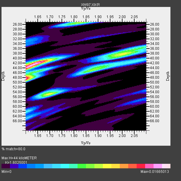
| Thickness Estimate: | 44 km |
| Thickness StdDev: | 6.8 km |
| Vp/Vs Estimate: | 1.60 |
| Vp/Vs StdDev: | 0.16 |
| Vs Estimate: | 3.856 km/s |
| Poisson's Ratio: | 0.18 |
| Peak Value: | 0.02 |
| Assumed Vp: | 6.18 km/s |
| Ps Weight: | 0.33333334 |
| PpPs Weight: | 0.33333334 |
| PsPs Weight: | 0.33333328 |
| Residual Complexity: | 0.825 |
| Nearby stations H: | +- |
| (2.0 deg) Vp/Vs: | +- |
5 with match > 90% ( 31.25 %) and 16 with match > 80% ( 100.0 %) out of 16.
Download stack as xyz text file.
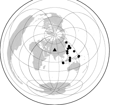
Azimuth Distribution of Events:
Prior Results for this Station
| Study | Thickness | Vp/Vs | Vp | Vs | Poissons Ratio | Extra |
| EARS | 44 km | 1.60 | 6.18 km/s | 3.856 km/s | 0.18 | |
| Crust2.0 | 55 km | 1.77 | 6.18 km/s | 3.496 km/s | 0.26 | PJ,orogen/55km, Tibet, 4.5 km seds. |
| Global Maxima | 44 km | 1.60 | 6.18 km/s | 3.856 km/s | 0.18 | amp=0.01665013 |
| Local Maxima 1 | 48 km | 1.60 | 6.18 km/s | 3.862 km/s | 0.18 | amp=0.0134917665 |
| Local Maxima 2 | 42 km | 1.64 | 6.18 km/s | 3.757 km/s | 0.21 | amp=0.011446597 |
| Local Maxima 3 | 55 km | 1.70 | 6.18 km/s | 3.646 km/s | 0.23 | amp=0.0106138745 |
| Local Maxima 4 | 25 km | 1.83 | 6.18 km/s | 3.382 km/s | 0.29 | amp=0.00927722 |
| Predicted Arrivals for vertical incidence (zero ray parameter) | |
| Ps | 4.29 SECOND |
| PpPs | 18.53 SECOND |
| PsPs/PpSs | 22.82 SECOND |
Events Processed for this Station
Download zip of receiver functions as SAC
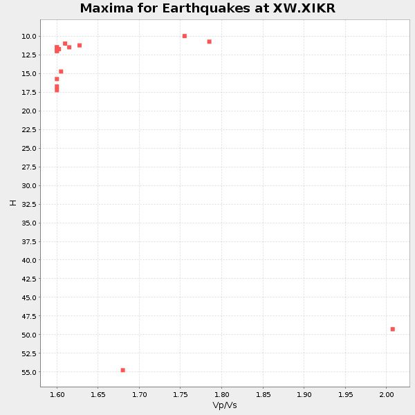
Plot maxima for each earthquake.
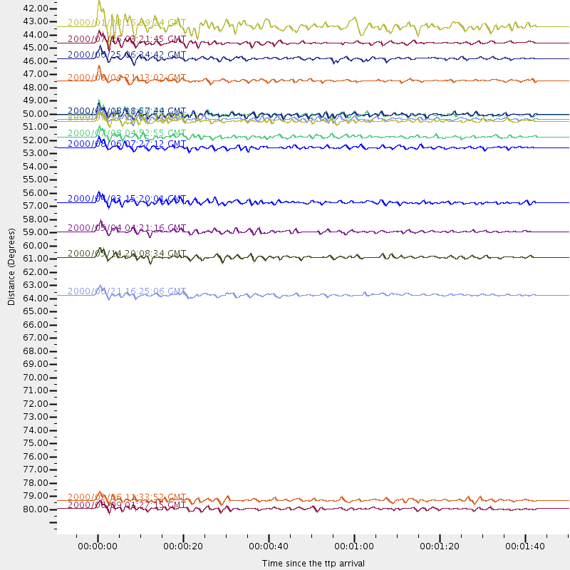
Events Used in the Stack
(16 events)| Radial Match | Distance | Baz | FERegion | Time | Lat/Lon | Depth | Magnitude |
| 93.398315 | 51.6 deg | 82.02 deg | Bonin Islands, Japan Region | 2000/08/06 07:27:12 GMT | (28.9, 139.6) | 395 km | 6.3 MB, 7.3 MW, 7.3 MW |
| 92.43397 | 42.8 deg | 103.689 deg | Philippine Islands Region | 2000/07/16 03:21:45 GMT | (20.3, 122.0) | 33 km | 6.1 MB, 6.3 MS, 6.4 MW, 6.4 MW |
| 91.61543 | 46.0 deg | 56.35 deg | Sakhalin, Russia | 2000/08/04 21:13:02 GMT | (48.8, 142.2) | 10 km | 6.3 MB, 7.1 MS, 6.8 MW, 6.7 MW |
| 91.22854 | 49.2 deg | 73.855 deg | Near East Coast Of Honshu, Japan | 2000/06/03 08:54:49 GMT | (35.6, 140.5) | 62 km | 5.6 MB, 5.6 MS, 6.1 MW, 6.1 MW |
| 90.50071 | 58.6 deg | 122.291 deg | Sulawesi, Indonesia | 2000/05/04 04:21:16 GMT | (-1.1, 123.6) | 26 km | 6.7 MB, 7.5 MS, 7.6 MW, 7.5 ME |
| 89.778725 | 81.9 deg | 103.475 deg | New Britain Region, P.N.G. | 2000/06/09 01:27:15 GMT | (-5.1, 152.5) | 33 km | 5.4 MB, 6.3 MS, 6.3 MW, 6.3 MW |
| 89.65742 | 48.8 deg | 76.269 deg | Near S. Coast Of Honshu, Japan | 2000/07/08 18:57:44 GMT | (34.1, 139.1) | 10 km | 5.9 MB, 5.6 MS, 6.0 MW, 5.9 MW |
| 89.45389 | 48.8 deg | 75.888 deg | Near S. Coast Of Honshu, Japan | 2000/07/15 01:30:30 GMT | (34.3, 139.3) | 10 km | 5.5 MB, 5.9 MS, 6.1 MW, 6.0 MW |
| 89.035965 | 60.8 deg | 125.01 deg | Banda Sea | 2000/05/14 20:08:34 GMT | (-4.3, 123.2) | 33 km | 5.9 MB, 5.9 MS, 6.3 MW, 6.2 MW |
| 88.548965 | 81.2 deg | 105.135 deg | New Britain Region, P.N.G. | 2000/02/06 11:33:52 GMT | (-5.8, 150.9) | 33 km | 6.6 MB, 6.8 MS, 6.6 MW, 6.3 ME |
| 86.48778 | 50.7 deg | 146.599 deg | Southern Sumatra, Indonesia | 2000/07/08 04:52:55 GMT | (-5.4, 102.7) | 33 km | 5.7 MB, 5.7 MS, 5.9 MW, 5.8 MW |
| 86.207 | 44.1 deg | 83.873 deg | Kyushu, Japan | 2000/06/25 06:34:42 GMT | (31.2, 131.2) | 10 km | 5.8 MB, 5.7 MS, 6.2 MW, 5.9 MW |
| 85.42088 | 63.9 deg | 93.143 deg | Mariana Islands | 2000/06/21 16:25:06 GMT | (14.1, 145.0) | 112 km | 5.7 MB, 6.0 MW, 5.9 MW |
| 84.922134 | 56.2 deg | 116.391 deg | Talaud Islands, Indonesia | 2000/04/03 15:20:01 GMT | (4.1, 125.6) | 150 km | 5.9 MB, 6.2 MW, 6.0 MW |
| 84.91043 | 49.4 deg | 146.246 deg | Southern Sumatra, Indonesia | 2000/07/22 20:56:12 GMT | (-4.1, 102.4) | 69 km | 5.8 MB, 5.8 MW, 5.7 MW |
| 84.82557 | 41.4 deg | 94.644 deg | Northeast Of Taiwan | 2000/01/28 16:39:24 GMT | (26.1, 124.5) | 194 km | 6.1 MB, 6.0 MW, 6.0 MW |
Losers
(0 events)| Radial Match | Distance | Baz | FERegion | Time | Lat/Lon | Depth | Magnitude | Reason |
