
Station XY PUPE - Puerto Penasco
Network: XY97 - Northern Baja Transect
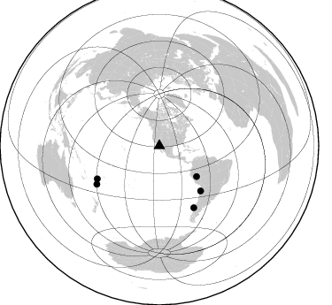
Nearby stations (2 deg radius)
| Station | Name | (Lat, Lon) | Start / End | Elevation |
| PUPE | Puerto Penasco | (31.34, -113.63) | 1997-10-28 / 2499-01-01 | 96 m |
| Crust2 Type: | M5,extended crust, 0.5 km seds. |
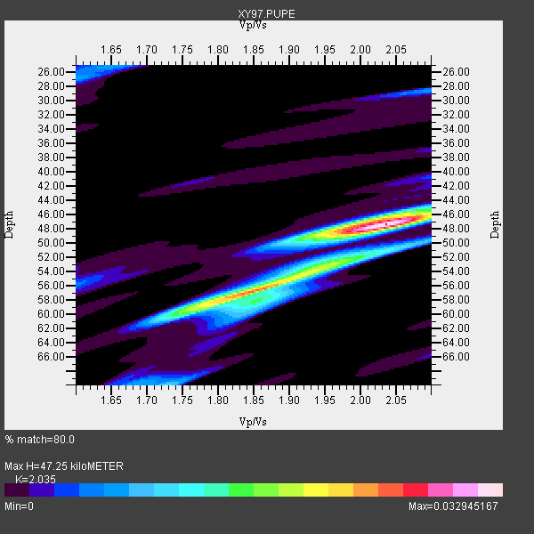
| Thickness Estimate: | 47 km |
| Thickness StdDev: | 5.3 km |
| Vp/Vs Estimate: | 2.04 |
| Vp/Vs StdDev: | 0.10 |
| Vs Estimate: | 3.084 km/s |
| Poisson's Ratio: | 0.34 |
| Peak Value: | 0.03 |
| Assumed Vp: | 6.276 km/s |
| Ps Weight: | 0.33333334 |
| PpPs Weight: | 0.33333334 |
| PsPs Weight: | 0.33333328 |
| Residual Complexity: | 0.559 |
| Nearby stations H: | +- |
| (2.0 deg) Vp/Vs: | +- |
4 with match > 90% ( 20.0 %) and 5 with match > 80% ( 25.0 %) out of 20.
Download stack as xyz text file.
Azimuth Distribution of Events:
Prior Results for this Station
| Study | Thickness | Vp/Vs | Vp | Vs | Poissons Ratio | Extra |
| EARS | 47 km | 2.04 | 6.276 km/s | 3.084 km/s | 0.34 | |
| Crust2.0 | 31 km | 1.78 | 6.276 km/s | 3.529 km/s | 0.27 | M5,extended crust, 0.5 km seds. |
| Global Maxima | 47 km | 2.04 | 6.276 km/s | 3.084 km/s | 0.34 | amp=0.032945167 |
| Local Maxima 1 | 57 km | 1.82 | 6.276 km/s | 3.444 km/s | 0.28 | amp=0.022654474 |
| Local Maxima 2 | 52 km | 1.98 | 6.276 km/s | 3.178 km/s | 0.33 | amp=0.012206911 |
| Local Maxima 3 | 60 km | 1.74 | 6.276 km/s | 3.617 km/s | 0.25 | amp=0.009100874 |
| Local Maxima 4 | 27 km | 1.60 | 6.276 km/s | 3.916 km/s | 0.18 | amp=0.007448894 |
| Predicted Arrivals for vertical incidence (zero ray parameter) | |
| Ps | 7.79 SECOND |
| PpPs | 22.85 SECOND |
| PsPs/PpSs | 30.64 SECOND |
Events Processed for this Station
Download zip of receiver functions as SAC
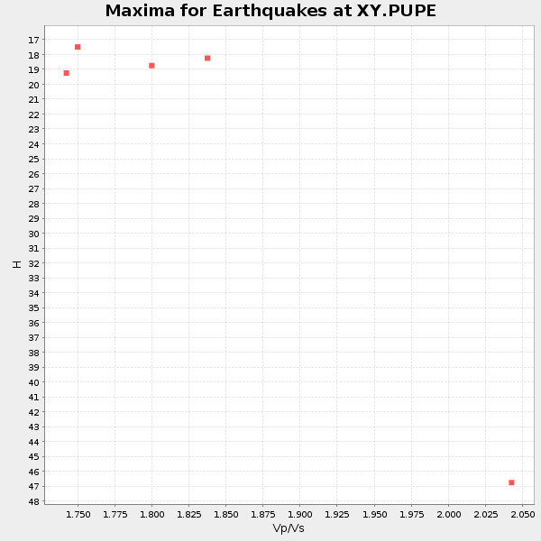
Plot maxima for each earthquake.
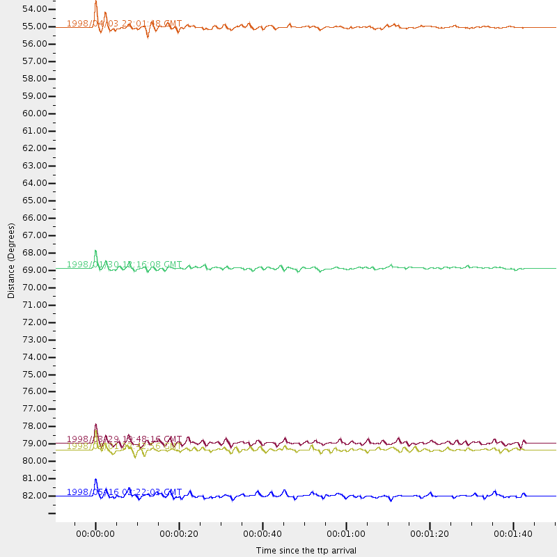
Events Used in the Stack
(5 events)| Radial Match | Distance | Baz | FERegion | Time | Lat/Lon | Depth | Magnitude |
| 95.84059 | 54.4 deg | 129.416 deg | Peru-Brazil Border Region | 1998/04/03 22:01:48 GMT | (-8.1, -74.2) | 165 km | 6.1 MB, 5.6 MS, 6.6 UNKNOWN, 6.6 MW |
| 91.78383 | 68.9 deg | 137.597 deg | Near Coast Of Northern Chile | 1998/01/30 12:16:08 GMT | (-23.9, -70.2) | 42 km | 6.3 MB, 6.5 MS, 7.0 UNKNOWN, 6.7 ME |
| 91.336 | 79.4 deg | 241.995 deg | Fiji Islands Region | 1998/03/29 19:48:16 GMT | (-17.6, -179.1) | 537 km | 6.5 MB, 7.2 UNKNOWN, 7.1 MW |
| 91.332436 | 79.8 deg | 150.9 deg | Off Coast Of Southern Chile | 1998/04/01 22:42:56 GMT | (-40.3, -74.9) | 9.0 km | 6.2 MB, 6.0 MS, 6.7 UNKNOWN, 6.6 ME |
| 88.26615 | 82.6 deg | 238.526 deg | South Of Fiji Islands | 1998/05/16 02:22:03 GMT | (-22.2, -179.5) | 586 km | 6.1 MB, 6.8 UNKNOWN |
Losers
(15 events)| Radial Match | Distance | Baz | FERegion | Time | Lat/Lon | Depth | Magnitude | Reason |
| 93.85679 | 50.0 deg | 128.518 deg | Northern Peru | 1997/10/28 06:15:17 GMT | (-4.4, -76.7) | 112 km | 6.6 MB, 6.3 MS, 7.2 UNKNOWN, 6.6 ME | |
| 79.39967 | 89.6 deg | 229.679 deg | South Of Kermadec Islands | 1998/04/10 16:43:41 GMT | (-33.5, -179.5) | 46 km | 5.9 MB, 5.9 MS, 6.0 UNKNOWN, 6.0 MW | |
| 73.83336 | 89.8 deg | 243.692 deg | Southeast Of Loyalty Islands | 1998/01/04 06:11:58 GMT | (-22.3, 170.9) | 101 km | 6.4 MB, 7.4 UNKNOWN, 7.3 ME | |
| 67.799774 | 78.5 deg | 243.601 deg | Fiji Islands Region | 1998/01/14 17:24:10 GMT | (-15.7, -179.3) | 33 km | 5.8 MB, 6.5 MS, 6.5 UNKNOWN, 6.5 MW | |
| 65.524124 | 63.6 deg | 10.257 deg | Greenland Sea | 1998/03/21 16:33:11 GMT | (79.9, 1.9) | 10 km | 5.9 MB, 6.1 MS, 6.2 UNKNOWN, 6.2 MW | |
| 60.28946 | 88.9 deg | 298.395 deg | Volcano Islands, Japan Region | 1998/02/07 01:13:36 GMT | (24.8, 141.8) | 526 km | 5.9 UNKNOWN, 5.4 MB | |
| 58.789284 | 86.4 deg | 231.478 deg | Kermadec Islands, New Zealand | 1998/06/20 20:24:45 GMT | (-30.1, -177.9) | 57 km | 5.7 MB, 6.0 UNKNOWN, 6.0 MW | |
| 58.70014 | 44.8 deg | 119.723 deg | Colombia | 1997/12/11 07:56:28 GMT | (3.9, -75.8) | 178 km | 6.0 MB, 6.4 UNKNOWN, 6.3 MW | |
| 58.130264 | 95.1 deg | 37.449 deg | Southern Italy | 1998/05/18 17:19:04 GMT | (39.3, 15.1) | 280 km | 5.6 MB | |
| 57.398605 | 52.5 deg | 312.902 deg | Rat Islands, Aleutian Islands | 1997/12/17 04:38:51 GMT | (51.2, 178.9) | 20 km | 5.8 MB, 6.5 MS, 6.7 UNKNOWN, 6.1 ME | |
| 51.161243 | 88.7 deg | 251.478 deg | Vanuatu Islands | 1997/11/15 18:59:24 GMT | (-15.1, 167.4) | 123 km | 6.4 MB, 7.0 UNKNOWN, 6.8 ME | |
| 49.665306 | 92.3 deg | 287.967 deg | Mariana Islands | 1998/05/15 05:58:06 GMT | (14.2, 144.9) | 154 km | 5.7 MB, 6.0 UNKNOWN, 6.0 MW | |
| 49.452877 | 83.8 deg | 237.469 deg | South Of Fiji Islands | 1998/04/14 03:41:22 GMT | (-23.8, -179.9) | 499 km | 5.5 MB, 6.2 UNKNOWN, 6.1 MW | |
| 46.13466 | 86.2 deg | 304.299 deg | Southeast Of Honshu, Japan | 1997/11/10 23:06:44 GMT | (31.2, 140.5) | 86 km | 5.8 MB, 6.1 UNKNOWN, 6.1 MW | |
| 26.02717 | 62.1 deg | 129.181 deg | Peru-Bolivia Border Region | 1997/11/28 22:53:41 GMT | (-13.7, -68.8) | 586 km | 6.4 MB, 6.6 UNKNOWN, 6.6 MW |
