
Station XY TELM - San Telmo
Network: XY97 - Northern Baja Transect
Nearby stations (2 deg radius)
| Station | Name | (Lat, Lon) | Start / End | Elevation |
| TELM | San Telmo | (30.98, -116.13) | 1997-10-16 / 2499-01-01 | 140 m |
| Crust2 Type: | S1,continental slope, margin, transition 1 km seds. |
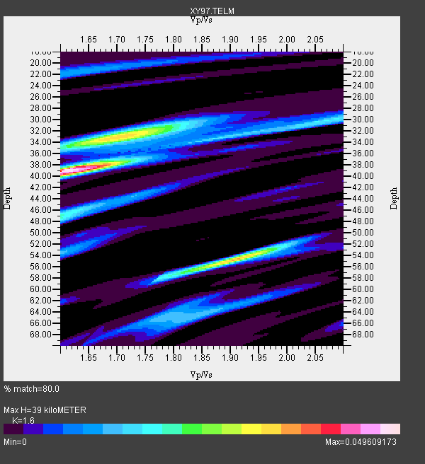
| Thickness Estimate: | 39 km |
| Thickness StdDev: | 13 km |
| Vp/Vs Estimate: | 1.60 |
| Vp/Vs StdDev: | 0.07 |
| Vs Estimate: | 3.864 km/s |
| Poisson's Ratio: | 0.18 |
| Peak Value: | 0.05 |
| Assumed Vp: | 6.183 km/s |
| Ps Weight: | 0.33333334 |
| PpPs Weight: | 0.33333334 |
| PsPs Weight: | 0.33333328 |
| Residual Complexity: | 0.806 |
| Nearby stations H: | +- |
| (2.0 deg) Vp/Vs: | +- |
1 with match > 90% ( 11.111111 %) and 3 with match > 80% ( 33.333332 %) out of 9.
Download stack as xyz text file.
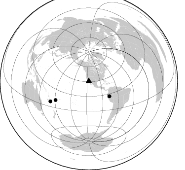
Azimuth Distribution of Events:
Prior Results for this Station
| Study | Thickness | Vp/Vs | Vp | Vs | Poissons Ratio | Extra |
| EARS | 39 km | 1.60 | 6.183 km/s | 3.864 km/s | 0.18 | |
| Crust2.0 | 23 km | 1.81 | 6.183 km/s | 3.422 km/s | 0.28 | S1,continental slope, margin, transition 1 km seds. |
| Global Maxima | 39 km | 1.60 | 6.183 km/s | 3.864 km/s | 0.18 | amp=0.049609173 |
| Local Maxima 1 | 54 km | 1.91 | 6.183 km/s | 3.233 km/s | 0.31 | amp=0.035006016 |
| Local Maxima 2 | 32 km | 1.72 | 6.183 km/s | 3.6 km/s | 0.24 | amp=0.031390205 |
| Local Maxima 3 | 47 km | 1.60 | 6.183 km/s | 3.864 km/s | 0.18 | amp=0.020531287 |
| Local Maxima 4 | 30 km | 2.07 | 6.183 km/s | 2.99 km/s | 0.35 | amp=0.016081661 |
| Predicted Arrivals for vertical incidence (zero ray parameter) | |
| Ps | 3.78 SECOND |
| PpPs | 16.40 SECOND |
| PsPs/PpSs | 20.19 SECOND |
Events Processed for this Station
Download zip of receiver functions as SAC
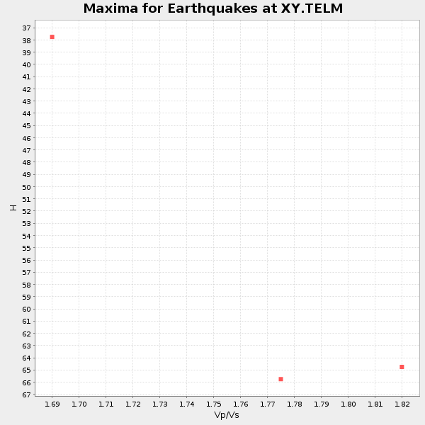
Plot maxima for each earthquake.
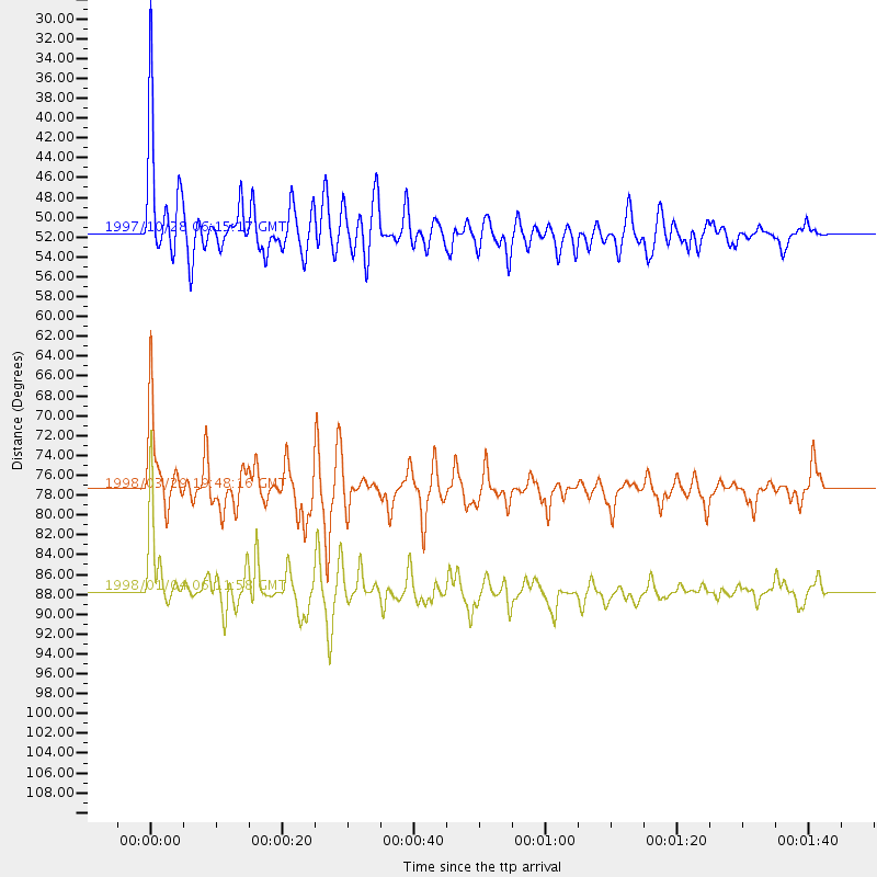
Events Used in the Stack
(3 events)| Radial Match | Distance | Baz | FERegion | Time | Lat/Lon | Depth | Magnitude |
| 91.53688 | 51.5 deg | 125.941 deg | Northern Peru | 1997/10/28 06:15:17 GMT | (-4.4, -76.7) | 112 km | 6.6 MB, 6.3 MS, 7.2 UNKNOWN, 6.6 ME |
| 89.905045 | 77.4 deg | 240.558 deg | Fiji Islands Region | 1998/03/29 19:48:16 GMT | (-17.6, -179.1) | 537 km | 6.5 MB, 7.2 UNKNOWN, 7.1 MW |
| 89.42171 | 87.7 deg | 242.389 deg | Southeast Of Loyalty Islands | 1998/01/04 06:11:58 GMT | (-22.3, 170.9) | 101 km | 6.4 MB, 7.4 UNKNOWN, 7.3 ME |
Losers
(6 events)| Radial Match | Distance | Baz | FERegion | Time | Lat/Lon | Depth | Magnitude | Reason |
| 77.478836 | 74.8 deg | 141.232 deg | Near Coast Of Central Chile | 1998/01/12 10:14:07 GMT | (-31.0, -71.4) | 35 km | 5.8 MB, 6.2 MS, 6.6 UNKNOWN, 6.2 ME | |
| 69.95282 | 63.6 deg | 127.072 deg | Peru-Bolivia Border Region | 1997/11/28 22:53:41 GMT | (-13.7, -68.8) | 586 km | 6.4 MB, 6.6 UNKNOWN, 6.6 MW | |
| 66.14238 | 87.5 deg | 296.343 deg | Volcano Islands, Japan Region | 1998/01/01 06:11:22 GMT | (23.9, 141.9) | 96 km | 6.4 MB, 5.8 MS, 6.8 UNKNOWN, 6.4 MW | |
| 65.15777 | 74.7 deg | 140.947 deg | Near Coast Of Central Chile | 1997/11/03 19:17:33 GMT | (-30.7, -71.2) | 45 km | 6.2 MB, 5.6 MS, 6.3 UNKNOWN, 5.8 MD | |
| 59.087353 | 84.6 deg | 303.13 deg | Southeast Of Honshu, Japan | 1997/11/10 23:06:44 GMT | (31.2, 140.5) | 86 km | 5.8 MB, 6.1 UNKNOWN, 6.1 MW | |
| 52.696922 | 82.6 deg | 154.709 deg | Off Coast Of Southern Chile | 1998/01/19 18:23:59 GMT | (-45.0, -79.5) | 10 km | 5.5 MS, 5.4 MB, 6.2 UNKNOWN, 6.2 MW |
