
Station XY GRAN - Playa Grande
Network: XY99 - Nicoya, Costa Rica
Nearby stations (2 deg radius)
| Station | Name | (Lat, Lon) | Start / End | Elevation |
| GRAN | Playa Grande | (10.34, -85.85) | 1999-12-06 / 2001-12-31 | 28 m |
| Crust2 Type: | L3,continental arc, Southern Andes, 0.2 km seds. |
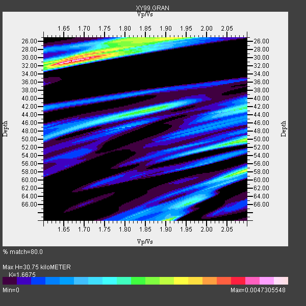
| Thickness Estimate: | 31 km |
| Thickness StdDev: | 15 km |
| Vp/Vs Estimate: | 1.67 |
| Vp/Vs StdDev: | 0.17 |
| Vs Estimate: | 3.957 km/s |
| Poisson's Ratio: | 0.22 |
| Peak Value: | 0.00 |
| Assumed Vp: | 6.597 km/s |
| Ps Weight: | 0.33333334 |
| PpPs Weight: | 0.33333334 |
| PsPs Weight: | 0.33333328 |
| Residual Complexity: | 0.774 |
| Nearby stations H: | +- |
| (2.0 deg) Vp/Vs: | +- |
4 with match > 90% ( 66.666664 %) and 6 with match > 80% ( 100.0 %) out of 6.
Download stack as xyz text file.
Azimuth Distribution of Events:

Prior Results for this Station
| Study | Thickness | Vp/Vs | Vp | Vs | Poissons Ratio | Extra |
| EARS | 31 km | 1.67 | 6.597 km/s | 3.957 km/s | 0.22 | |
| Crust2.0 | 40 km | 1.77 | 6.597 km/s | 3.723 km/s | 0.27 | L3,continental arc, Southern Andes, 0.2 km seds. |
| Global Maxima | 31 km | 1.67 | 6.597 km/s | 3.957 km/s | 0.22 | amp=0.0047305548 |
| Local Maxima 1 | 58 km | 2.10 | 6.597 km/s | 3.145 km/s | 0.35 | amp=0.0029350203 |
| Local Maxima 2 | 25 km | 1.92 | 6.597 km/s | 3.427 km/s | 0.32 | amp=0.0028919722 |
| Local Maxima 3 | 50 km | 2.10 | 6.597 km/s | 3.145 km/s | 0.35 | amp=0.0028009731 |
| Local Maxima 4 | 42 km | 1.87 | 6.597 km/s | 3.533 km/s | 0.30 | amp=0.002443843 |
| Predicted Arrivals for vertical incidence (zero ray parameter) | |
| Ps | 3.11 SECOND |
| PpPs | 12.43 SECOND |
| PsPs/PpSs | 15.54 SECOND |
Events Processed for this Station
Download zip of receiver functions as SAC
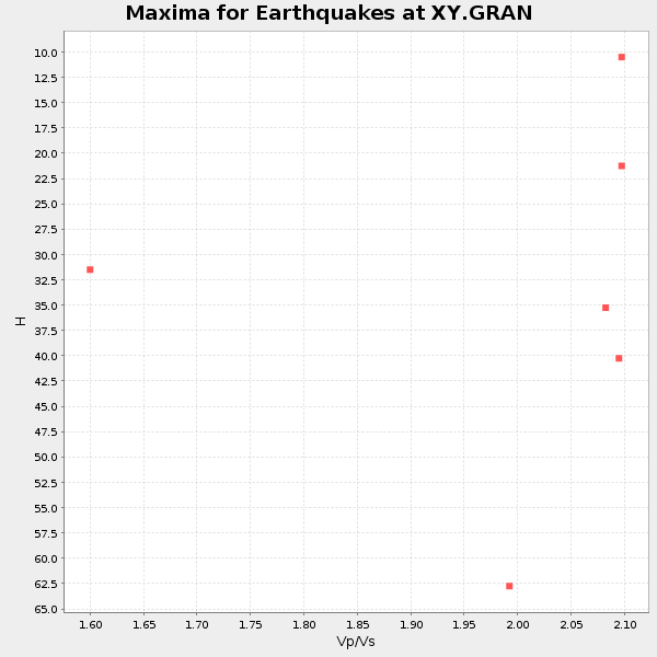
Plot maxima for each earthquake.
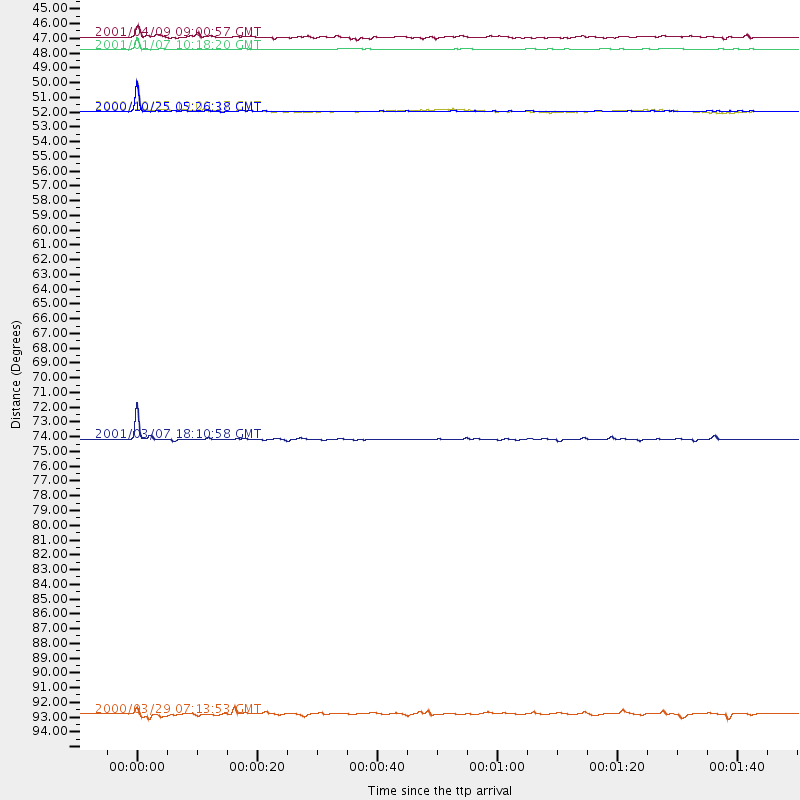
Events Used in the Stack
(6 events)| Radial Match | Distance | Baz | FERegion | Time | Lat/Lon | Depth | Magnitude |
| 97.7116 | 50.1 deg | 205.728 deg | Southern East Pacific Rise | 2000/10/25 05:26:38 GMT | (-34.6, -109.6) | 10 km | 5.6 MB, 5.7 MS, 6.0 MW, 6.0 MW |
| 96.19005 | 50.1 deg | 205.504 deg | Southern East Pacific Rise | 2000/10/25 19:00:17 GMT | (-34.7, -109.5) | 10 km | 5.6 MB, 5.7 MS, 6.1 MW, 6.1 MW |
| 94.0864 | 44.5 deg | 164.604 deg | Off Coast Of Central Chile | 2001/04/09 09:00:57 GMT | (-32.7, -73.1) | 11 km | 6.1 MB, 6.3 MS, 6.7 MW, 6.3 ME |
| 93.99352 | 74.6 deg | 100.028 deg | Ascension Island Region | 2001/03/07 18:10:58 GMT | (-6.8, -12.9) | 10 km | 5.3 MB, 5.6 MS, 6.0 MW, 6.0 MW |
| 87.91506 | 45.4 deg | 163.964 deg | Off Coast Of Central Chile | 2001/01/07 10:18:20 GMT | (-33.4, -72.2) | 10 km | 5.4 MB, 5.7 MS, 6.0 MW, 5.3 MD |
| 81.60253 | 95.2 deg | 242.479 deg | Kermadec Islands Region | 2000/03/29 07:13:53 GMT | (-28.1, -176.3) | 10 km | 5.1 MB, 5.9 MS, 6.1 MW, 5.7 MW |
Losers
(0 events)| Radial Match | Distance | Baz | FERegion | Time | Lat/Lon | Depth | Magnitude | Reason |
