
Station XY HATA - Hacienda Tamarindo
Network: XY99 - Nicoya, Costa Rica
Nearby stations (2 deg radius)
| Station | Name | (Lat, Lon) | Start / End | Elevation |
| HATA | Hacienda Tamarindo | (10.43, -85.28) | 1999-12-07 / 2001-12-31 | 44 m |
| Crust2 Type: | L3,continental arc, Southern Andes, 0.2 km seds. |
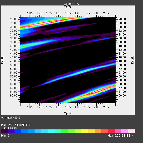
| Thickness Estimate: | 28 km |
| Thickness StdDev: | 17 km |
| Vp/Vs Estimate: | 1.69 |
| Vp/Vs StdDev: | 0.15 |
| Vs Estimate: | 3.898 km/s |
| Poisson's Ratio: | 0.23 |
| Peak Value: | 0.00 |
| Assumed Vp: | 6.597 km/s |
| Ps Weight: | 0.33333334 |
| PpPs Weight: | 0.33333334 |
| PsPs Weight: | 0.33333328 |
| Residual Complexity: | 0.747 |
| Nearby stations H: | +- |
| (2.0 deg) Vp/Vs: | +- |
2 with match > 90% ( 66.666664 %) and 3 with match > 80% ( 100.0 %) out of 3.
Download stack as xyz text file.
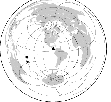
Azimuth Distribution of Events:
Prior Results for this Station
| Study | Thickness | Vp/Vs | Vp | Vs | Poissons Ratio | Extra |
| EARS | 28 km | 1.69 | 6.597 km/s | 3.898 km/s | 0.23 | |
| Crust2.0 | 40 km | 1.77 | 6.597 km/s | 3.723 km/s | 0.27 | L3,continental arc, Southern Andes, 0.2 km seds. |
| Global Maxima | 28 km | 1.69 | 6.597 km/s | 3.898 km/s | 0.23 | amp=0.0036838914 |
| Local Maxima 1 | 63 km | 2.01 | 6.597 km/s | 3.278 km/s | 0.34 | amp=0.0035288502 |
| Local Maxima 2 | 60 km | 2.10 | 6.597 km/s | 3.149 km/s | 0.35 | amp=0.0025123304 |
| Local Maxima 3 | 25 km | 1.90 | 6.597 km/s | 3.463 km/s | 0.31 | amp=0.0021138492 |
| Local Maxima 4 | 67 km | 1.91 | 6.597 km/s | 3.459 km/s | 0.31 | amp=0.0019930948 |
| Predicted Arrivals for vertical incidence (zero ray parameter) | |
| Ps | 2.99 SECOND |
| PpPs | 11.63 SECOND |
| PsPs/PpSs | 14.62 SECOND |
Events Processed for this Station
Download zip of receiver functions as SAC
Plot maxima for each earthquake.
Events Used in the Stack
(3 events)| Radial Match | Distance | Baz | FERegion | Time | Lat/Lon | Depth | Magnitude |
| 97.43511 | 93.2 deg | 252.522 deg | Tonga Islands | 2000/10/31 18:43:20 GMT | (-17.9, -175.3) | 33 km | 5.8 MB, 5.9 MS, 6.1 MW |
| 92.74964 | 97.5 deg | 243.009 deg | Kermadec Islands Region | 2000/04/11 06:41:26 GMT | (-27.9, -178.4) | 201 km | 5.6 MB, 5.9 MW, 5.8 MW |
| 85.80348 | 93.2 deg | 252.119 deg | Tonga Islands | 2000/04/07 18:42:23 GMT | (-18.3, -175.3) | 208 km | 5.4 MB, 5.8 MW, 5.8 MW |
Losers
(0 events)| Radial Match | Distance | Baz | FERegion | Time | Lat/Lon | Depth | Magnitude | Reason |
