
Station XY HOJA - Hojancha
Network: XY99 - Nicoya, Costa Rica
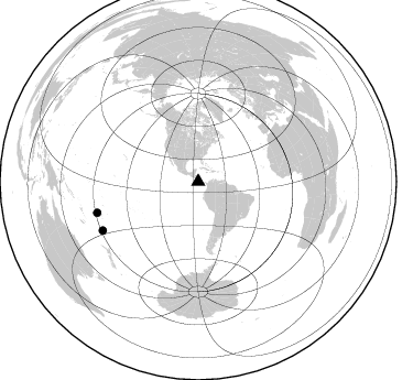
Nearby stations (2 deg radius)
| Station | Name | (Lat, Lon) | Start / End | Elevation |
| HOJA | Hojancha | (10.05, -85.42) | 2000-01-20 / 2001-12-31 | 356 m |
| Crust2 Type: | L3,continental arc, Southern Andes, 0.2 km seds. |
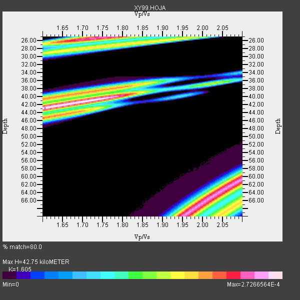
| Thickness Estimate: | 43 km |
| Thickness StdDev: | 0.6 km |
| Vp/Vs Estimate: | 1.61 |
| Vp/Vs StdDev: | 0.14 |
| Vs Estimate: | 4.111 km/s |
| Poisson's Ratio: | 0.18 |
| Peak Value: | 0.00 |
| Assumed Vp: | 6.597 km/s |
| Ps Weight: | 0.33333334 |
| PpPs Weight: | 0.33333334 |
| PsPs Weight: | 0.33333328 |
| Residual Complexity: | 0.881 |
| Nearby stations H: | +- |
| (2.0 deg) Vp/Vs: | +- |
2 with match > 90% ( 100.0 %) and 2 with match > 80% ( 100.0 %) out of 2.
Download stack as xyz text file.
Azimuth Distribution of Events:
Prior Results for this Station
| Study | Thickness | Vp/Vs | Vp | Vs | Poissons Ratio | Extra |
| EARS | 43 km | 1.61 | 6.597 km/s | 4.111 km/s | 0.18 | |
| Crust2.0 | 40 km | 1.77 | 6.597 km/s | 3.723 km/s | 0.27 | L3,continental arc, Southern Andes, 0.2 km seds. |
| Global Maxima | 43 km | 1.61 | 6.597 km/s | 4.111 km/s | 0.18 | amp=2.7266564E-4 |
| Local Maxima 1 | 63 km | 2.06 | 6.597 km/s | 3.21 km/s | 0.34 | amp=2.466882E-4 |
| Local Maxima 2 | 25 km | 1.76 | 6.597 km/s | 3.749 km/s | 0.26 | amp=2.3804899E-4 |
| Local Maxima 3 | 38 km | 1.75 | 6.597 km/s | 3.781 km/s | 0.26 | amp=1.9552516E-4 |
| Local Maxima 4 | 67 km | 1.99 | 6.597 km/s | 3.324 km/s | 0.33 | amp=1.9530351E-4 |
| Predicted Arrivals for vertical incidence (zero ray parameter) | |
| Ps | 3.92 SECOND |
| PpPs | 16.88 SECOND |
| PsPs/PpSs | 20.80 SECOND |
Events Processed for this Station
Download zip of receiver functions as SAC
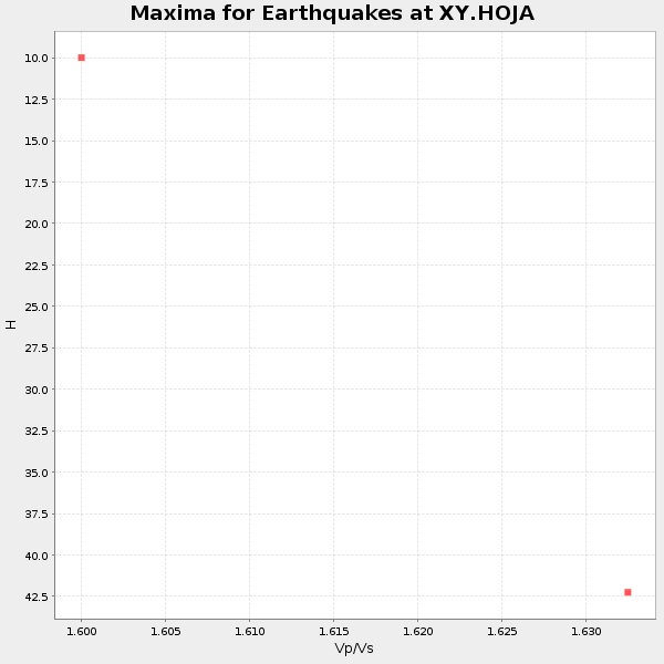
Plot maxima for each earthquake.
Events Used in the Stack
(2 events)| Radial Match | Distance | Baz | FERegion | Time | Lat/Lon | Depth | Magnitude |
| 99.956894 | 97.2 deg | 242.949 deg | Kermadec Islands Region | 2000/04/11 06:41:26 GMT | (-27.9, -178.4) | 201 km | 5.6 MB, 5.9 MW, 5.8 MW |
| 99.06509 | 96.0 deg | 252.917 deg | Fiji Islands Region | 2000/05/04 20:36:32 GMT | (-17.9, -178.5) | 516 km | 5.6 MB, 6.5 MW, 6.4 MW |
Losers
(0 events)| Radial Match | Distance | Baz | FERegion | Time | Lat/Lon | Depth | Magnitude | Reason |
