
Station XY PNCB - Parque Nacional Cabo Blanco
Network: XY99 - Nicoya, Costa Rica
Nearby stations (2 deg radius)
| Station | Name | (Lat, Lon) | Start / End | Elevation |
| PNCB | Parque Nacional Cabo Blanco | (9.59, -85.09) | 1999-12-05 / 2001-12-31 | 18 m |
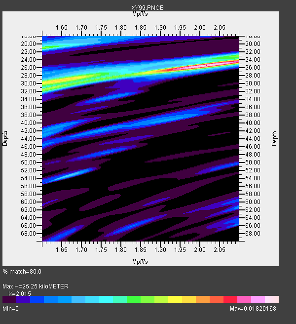
| Crust2 Type: | S1,continental slope, margin, transition 1 km seds. |
| Thickness Estimate: | 25 km |
| Thickness StdDev: | 6.4 km |
| Vp/Vs Estimate: | 2.02 |
| Vp/Vs StdDev: | 0.21 |
| Vs Estimate: | 3.068 km/s |
| Poisson's Ratio: | 0.34 |
| Peak Value: | 0.02 |
| Assumed Vp: | 6.183 km/s |
| Ps Weight: | 0.33333334 |
| PpPs Weight: | 0.33333334 |
| PsPs Weight: | 0.33333328 |
| Residual Complexity: | 0.620 |
| Nearby stations H: | +- |
| (2.0 deg) Vp/Vs: | +- |
3 with match > 90% ( 50.0 %) and 6 with match > 80% ( 100.0 %) out of 6.
Download stack as xyz text file.
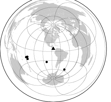
Azimuth Distribution of Events:
Prior Results for this Station
| Study | Thickness | Vp/Vs | Vp | Vs | Poissons Ratio | Extra |
| EARS | 25 km | 2.02 | 6.183 km/s | 3.068 km/s | 0.34 | |
| Crust2.0 | 23 km | 1.81 | 6.183 km/s | 3.422 km/s | 0.28 | S1,continental slope, margin, transition 1 km seds. |
| Global Maxima | 25 km | 2.02 | 6.183 km/s | 3.068 km/s | 0.34 | amp=0.01820168 |
| Local Maxima 1 | 31 km | 1.63 | 6.183 km/s | 3.787 km/s | 0.20 | amp=0.009847032 |
| Local Maxima 2 | 21 km | 1.60 | 6.183 km/s | 3.858 km/s | 0.18 | amp=0.009600618 |
| Local Maxima 3 | 30 km | 1.62 | 6.183 km/s | 3.805 km/s | 0.20 | amp=0.0076850513 |
| Local Maxima 4 | 54 km | 1.65 | 6.183 km/s | 3.736 km/s | 0.21 | amp=0.0058980715 |
| Predicted Arrivals for vertical incidence (zero ray parameter) | |
| Ps | 4.15 SECOND |
| PpPs | 12.31 SECOND |
| PsPs/PpSs | 16.46 SECOND |
Events Processed for this Station
Download zip of receiver functions as SAC
Plot maxima for each earthquake.
Events Used in the Stack
(6 events)| Radial Match | Distance | Baz | FERegion | Time | Lat/Lon | Depth | Magnitude |
| 94.72847 | 93.1 deg | 252.508 deg | Tonga Islands | 2000/10/31 18:43:20 GMT | (-17.9, -175.3) | 33 km | 5.8 MB, 5.9 MS, 6.1 MW |
| 92.50746 | 95.9 deg | 252.887 deg | Fiji Islands Region | 2000/09/02 10:19:13 GMT | (-17.9, -178.3) | 588 km | 5.1 MB, 5.8 MW, 5.7 MW |
| 90.10553 | 49.7 deg | 206.696 deg | Southern East Pacific Rise | 2000/10/25 05:26:38 GMT | (-34.6, -109.6) | 10 km | 5.6 MB, 5.7 MS, 6.0 MW, 6.0 MW |
| 86.56778 | 79.5 deg | 151.719 deg | South Sandwich Islands Region | 2000/11/07 00:18:04 GMT | (-55.6, -29.9) | 10 km | 6.7 MS, 6.8 MW, 6.6 MW |
| 81.180405 | 93.2 deg | 248.458 deg | Tonga Islands | 2000/08/17 00:04:29 GMT | (-21.9, -174.8) | 33 km | 5.4 MB, 5.8 MS, 5.9 MW, 5.7 MW |
| 80.97547 | 91.7 deg | 252.973 deg | Tonga Islands | 2000/09/26 06:17:52 GMT | (-17.2, -173.9) | 56 km | 6.1 MB, 6.1 MS, 6.4 MW, 6.1 ME |
Losers
(0 events)| Radial Match | Distance | Baz | FERegion | Time | Lat/Lon | Depth | Magnitude | Reason |
