
Station XZ S06 - Thumrait
Network: XZ03 - DHOFAR Seismic Experiment
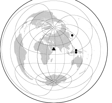
Nearby stations (2 deg radius)
| Station | Name | (Lat, Lon) | Start / End | Elevation |
| S06 | Thumrait | (17.62, 54.05) | 2003-03-22 / 2004-03-22 | 480 m |
| Crust2 Type: | S1,continental slope, margin, transition 1 km seds. |
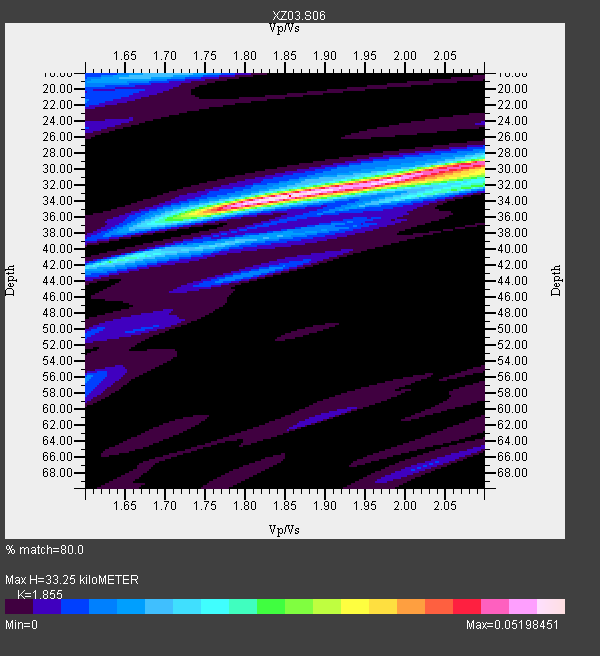
| Thickness Estimate: | 33 km |
| Thickness StdDev: | 2.0 km |
| Vp/Vs Estimate: | 1.86 |
| Vp/Vs StdDev: | 0.12 |
| Vs Estimate: | 3.333 km/s |
| Poisson's Ratio: | 0.30 |
| Peak Value: | 0.05 |
| Assumed Vp: | 6.183 km/s |
| Ps Weight: | 0.33333334 |
| PpPs Weight: | 0.33333334 |
| PsPs Weight: | 0.33333328 |
| Residual Complexity: | 0.541 |
| Nearby stations H: | +- |
| (2.0 deg) Vp/Vs: | +- |
1 with match > 90% ( 12.5 %) and 3 with match > 80% ( 37.5 %) out of 8.
Download stack as xyz text file.
Azimuth Distribution of Events:
Prior Results for this Station
| Study | Thickness | Vp/Vs | Vp | Vs | Poissons Ratio | Extra |
| EARS | 33 km | 1.86 | 6.183 km/s | 3.333 km/s | 0.30 | |
| Crust2.0 | 23 km | 1.81 | 6.183 km/s | 3.422 km/s | 0.28 | S1,continental slope, margin, transition 1 km seds. |
| Global Maxima | 33 km | 1.86 | 6.183 km/s | 3.333 km/s | 0.30 | amp=0.05198451 |
| Local Maxima 1 | 29 km | 2.10 | 6.183 km/s | 2.951 km/s | 0.35 | amp=0.043367762 |
| Local Maxima 2 | 42 km | 1.63 | 6.183 km/s | 3.793 km/s | 0.20 | amp=0.021580206 |
| Local Maxima 3 | 32 km | 2.09 | 6.183 km/s | 2.955 km/s | 0.35 | amp=0.019809565 |
| Local Maxima 4 | 31 km | 1.99 | 6.183 km/s | 3.115 km/s | 0.33 | amp=0.017613715 |
| Predicted Arrivals for vertical incidence (zero ray parameter) | |
| Ps | 4.60 SECOND |
| PpPs | 15.35 SECOND |
| PsPs/PpSs | 19.95 SECOND |
Events Processed for this Station
Download zip of receiver functions as SAC
Plot maxima for each earthquake.
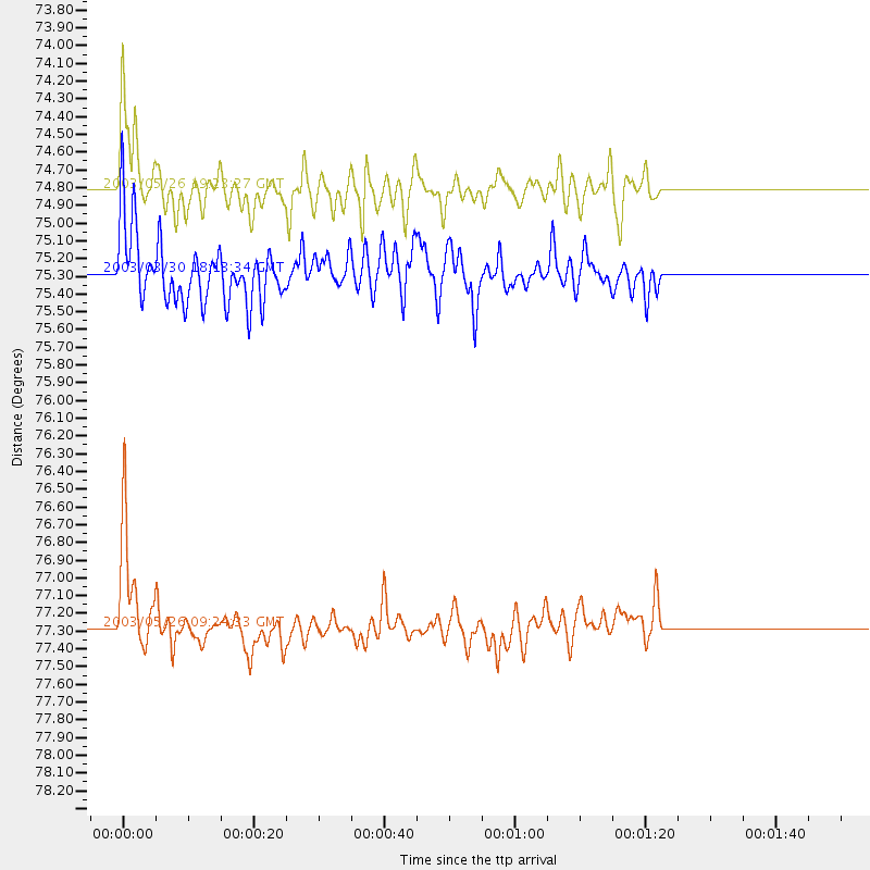
Events Used in the Stack
(3 events)| Radial Match | Distance | Baz | FERegion | Time | Lat/Lon | Depth | Magnitude |
| 91.51915 | 77.3 deg | 53.107 deg | Near East Coast Of Honshu, Japan | 2003/05/26 09:24:33 GMT | (38.8, 141.6) | 68 km | 6.7 MB, 7.0 MW, 7.0 MW |
| 88.780624 | 74.8 deg | 92.369 deg | Halmahera, Indonesia | 2003/05/26 19:23:27 GMT | (2.4, 128.9) | 31 km | 6.5 MB, 7.1 MS, 7.0 MW, 6.8 MW |
| 83.64235 | 75.3 deg | 98.187 deg | Seram, Indonesia | 2003/03/30 18:13:34 GMT | (-3.2, 127.5) | 33 km | 5.8 MB, 6.0 MS, 6.2 MW, 6.2 MW |
Losers
(5 events)| Radial Match | Distance | Baz | FERegion | Time | Lat/Lon | Depth | Magnitude | Reason |
| 74.99386 | 68.6 deg | 89.529 deg | Mindanao, Philippines | 2003/05/26 23:13:29 GMT | (6.8, 123.7) | 566 km | 6.2 MB, 6.8 MW, 6.8 MW | |
| 74.07529 | 54.8 deg | 112.238 deg | Southwest Of Sumatra, Indonesia | 2003/04/29 10:44:36 GMT | (-7.0, 103.7) | 10 km | 5.6 MB, 5.7 MS, 5.8 MW, 5.7 MW | |
| 72.02195 | 48.2 deg | 304.025 deg | Northern Algeria | 2003/05/27 17:11:28 GMT | (36.9, 3.6) | 8.0 km | 5.5 MB, 5.5 MS, 5.8 MW, 5.7 MW | |
| 59.382267 | 74.1 deg | 45.013 deg | Primor'ye, Russia | 2003/07/27 06:25:31 GMT | (47.2, 139.2) | 470 km | 6.3 MB, 6.8 MW, 6.8 MW | |
| 58.274178 | 80.7 deg | 47.166 deg | Kuril Islands | 2003/04/29 13:53:17 GMT | (43.7, 147.8) | 62 km | 6.0 MB, 6.0 MW, 5.9 MW |
