
Station XZ S07 - Jibjaat
Network: XZ03 - DHOFAR Seismic Experiment
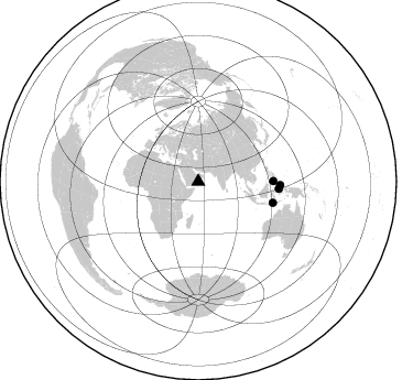
Nearby stations (2 deg radius)
| Station | Name | (Lat, Lon) | Start / End | Elevation |
| S07 | Jibjaat | (17.25, 54.49) | 2003-03-18 / 2003-12-12 | 939 m |
| Crust2 Type: | S1,continental slope, margin, transition 1 km seds. |
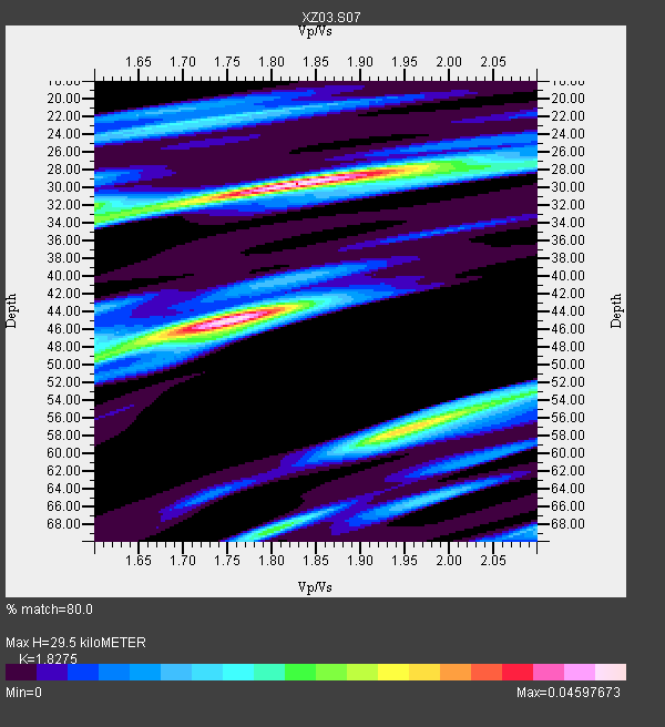
| Thickness Estimate: | 30 km |
| Thickness StdDev: | 9.2 km |
| Vp/Vs Estimate: | 1.83 |
| Vp/Vs StdDev: | 0.09 |
| Vs Estimate: | 3.383 km/s |
| Poisson's Ratio: | 0.29 |
| Peak Value: | 0.05 |
| Assumed Vp: | 6.183 km/s |
| Ps Weight: | 0.33333334 |
| PpPs Weight: | 0.33333334 |
| PsPs Weight: | 0.33333328 |
| Residual Complexity: | 0.796 |
| Nearby stations H: | +- |
| (2.0 deg) Vp/Vs: | +- |
2 with match > 90% ( 20.0 %) and 4 with match > 80% ( 40.0 %) out of 10.
Download stack as xyz text file.
Azimuth Distribution of Events:
Prior Results for this Station
| Study | Thickness | Vp/Vs | Vp | Vs | Poissons Ratio | Extra |
| EARS | 30 km | 1.83 | 6.183 km/s | 3.383 km/s | 0.29 | |
| Crust2.0 | 23 km | 1.81 | 6.183 km/s | 3.422 km/s | 0.28 | S1,continental slope, margin, transition 1 km seds. |
| Global Maxima | 30 km | 1.83 | 6.183 km/s | 3.383 km/s | 0.29 | amp=0.04597673 |
| Local Maxima 1 | 45 km | 1.75 | 6.183 km/s | 3.538 km/s | 0.26 | amp=0.04579892 |
| Local Maxima 2 | 57 km | 1.95 | 6.183 km/s | 3.175 km/s | 0.32 | amp=0.03209405 |
| Local Maxima 3 | 34 km | 1.60 | 6.183 km/s | 3.864 km/s | 0.18 | amp=0.021354545 |
| Local Maxima 4 | 49 km | 1.60 | 6.183 km/s | 3.864 km/s | 0.18 | amp=0.0200029 |
| Predicted Arrivals for vertical incidence (zero ray parameter) | |
| Ps | 3.95 SECOND |
| PpPs | 13.49 SECOND |
| PsPs/PpSs | 17.44 SECOND |
Events Processed for this Station
Download zip of receiver functions as SAC
Plot maxima for each earthquake.
Events Used in the Stack
(4 events)| Radial Match | Distance | Baz | FERegion | Time | Lat/Lon | Depth | Magnitude |
| 92.44865 | 74.4 deg | 92.404 deg | Halmahera, Indonesia | 2003/05/26 19:23:27 GMT | (2.4, 128.9) | 31 km | 6.5 MB, 7.1 MS, 7.0 MW, 6.8 MW |
| 90.36673 | 70.2 deg | 105.687 deg | Flores Region, Indonesia | 2003/03/25 02:53:25 GMT | (-8.3, 120.7) | 33 km | 6.2 MB, 6.1 MS, 6.5 MW, 6.3 MW |
| 89.2254 | 68.2 deg | 89.514 deg | Mindanao, Philippines | 2003/05/26 23:13:29 GMT | (6.8, 123.7) | 566 km | 6.2 MB, 6.8 MW, 6.8 MW |
| 82.5091 | 73.6 deg | 94.981 deg | Halmahera, Indonesia | 2003/05/05 15:50:08 GMT | (0.2, 127.4) | 124 km | 5.9 MB, 6.4 MW, 6.4 MW |
Losers
(6 events)| Radial Match | Distance | Baz | FERegion | Time | Lat/Lon | Depth | Magnitude | Reason |
| 77.25238 | 77.8 deg | 55.647 deg | Near East Coast Of Honshu, Japan | 2003/04/07 18:28:37 GMT | (36.3, 141.7) | 33 km | 5.5 MB, 5.5 MS, 5.9 MW, 5.8 MW | |
| 77.172035 | 31.9 deg | 316.44 deg | Aegean Sea | 2003/04/10 00:40:15 GMT | (38.2, 27.0) | 10 km | 5.6 MS, 5.3 MB, 5.7 MW, 5.7 MW | |
| 62.272583 | 83.9 deg | 40.863 deg | Kuril Islands | 2003/04/24 10:56:21 GMT | (48.8, 155.0) | 44 km | 5.6 MB, 5.7 MS, 6.1 MW, 6.0 MW | |
| 61.86334 | 80.6 deg | 47.205 deg | Kuril Islands | 2003/04/29 13:53:17 GMT | (43.7, 147.8) | 62 km | 6.0 MB, 6.0 MW, 5.9 MW | |
| 60.000877 | 74.0 deg | 44.986 deg | Primor'ye, Russia | 2003/07/27 06:25:31 GMT | (47.2, 139.2) | 470 km | 6.3 MB, 6.8 MW, 6.8 MW | |
| 54.787663 | 48.8 deg | 304.215 deg | Northern Algeria | 2003/05/27 17:11:28 GMT | (36.9, 3.6) | 8.0 km | 5.5 MB, 5.5 MS, 5.8 MW, 5.7 MW |
