
Station Y2 BA02 - Westup
Network: Y213 - Balcombe
Nearby stations (2 deg radius)
| Station | Name | (Lat, Lon) | Start / End | Elevation |
| BA02 | Westup | (51.06, -0.15) | 2013-07-01 / 2013-09-25 | 167 m |
| Crust2 Type: | M8,thick extended crust, 1.5 km seds. |
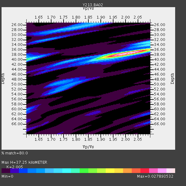
| Thickness Estimate: | 37 km |
| Thickness StdDev: | 2.6 km |
| Vp/Vs Estimate: | 2.01 |
| Vp/Vs StdDev: | 0.09 |
| Vs Estimate: | 3.096 km/s |
| Poisson's Ratio: | 0.33 |
| Peak Value: | 0.03 |
| Assumed Vp: | 6.207 km/s |
| Ps Weight: | 0.33333334 |
| PpPs Weight: | 0.33333334 |
| PsPs Weight: | 0.33333328 |
| Residual Complexity: | 0.438 |
| Nearby stations H: | +- |
| (2.0 deg) Vp/Vs: | +- |
2 with match > 90% ( 16.666666 %) and 4 with match > 80% ( 33.333332 %) out of 12.
Download stack as xyz text file.
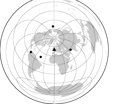
Azimuth Distribution of Events:
Prior Results for this Station
| Study | Thickness | Vp/Vs | Vp | Vs | Poissons Ratio | Extra |
| EARS | 37 km | 2.01 | 6.207 km/s | 3.096 km/s | 0.33 | |
| Crust2.0 | 37 km | 1.78 | 6.207 km/s | 3.489 km/s | 0.27 | M8,thick extended crust, 1.5 km seds. |
| Global Maxima | 37 km | 2.01 | 6.207 km/s | 3.096 km/s | 0.33 | amp=0.027893532 |
| Local Maxima 1 | 40 km | 1.61 | 6.207 km/s | 3.861 km/s | 0.18 | amp=0.013712029 |
| Local Maxima 2 | 28 km | 1.73 | 6.207 km/s | 3.598 km/s | 0.25 | amp=0.007914033 |
| Local Maxima 3 | 25 km | 1.87 | 6.207 km/s | 3.328 km/s | 0.30 | amp=0.006347512 |
| Local Maxima 4 | 52 km | 1.74 | 6.207 km/s | 3.572 km/s | 0.25 | amp=0.005726681 |
| Predicted Arrivals for vertical incidence (zero ray parameter) | |
| Ps | 6.03 SECOND |
| PpPs | 18.03 SECOND |
| PsPs/PpSs | 24.07 SECOND |
Events Processed for this Station
Download zip of receiver functions as SAC
Plot maxima for each earthquake.
Events Used in the Stack
(4 events)| Radial Match | Distance | Baz | FERegion | Time | Lat/Lon | Depth | Magnitude |
| 93.79297 | 54.4 deg | 90.07 deg | Pakistan | 2013/09/24 11:29:47 GMT | (27.0, 65.5) | 15 km | 7.7 MWW, 7.7 MWC, 7.8 MWC |
| 92.11649 | 77.7 deg | 356.859 deg | Andreanof Islands, Aleutian Is. | 2013/08/30 16:25:02 GMT | (51.5, -175.2) | 29 km | 7.0 MWW, 6.5 ML, 6.8 MI, 6.9 MWC, 6.9 MWB, 7.0 MWW, 7.0 MI, 7.0 MWC |
| 82.20999 | 78.0 deg | 264.326 deg | South Of Panama | 2013/08/13 15:43:15 GMT | (5.8, -78.2) | 12 km | 6.7 MWW, 6.6 MWB, 6.7 MWW, 6.7 MWC, 6.7 MI |
| 81.444244 | 50.8 deg | 241.935 deg | Northern Mid-Atlantic Ridge | 2013/09/05 04:01:36 GMT | (15.2, -45.2) | 10 km | 6.0 MWW, 5.9 MWB, 6.0 MWW, 6.0 MWC |
Losers
(8 events)| Radial Match | Distance | Baz | FERegion | Time | Lat/Lon | Depth | Magnitude | Reason |
| 67.715225 | 82.8 deg | 287.77 deg | Near Coast Of Guerrero, Mexico | 2013/08/21 12:38:29 GMT | (16.9, -99.5) | 21 km | 6.2 MWW, 6.2 MWW, 6.2 MWB, 6.2 MWC | |
| 67.61466 | 77.9 deg | 23.45 deg | Sea Of Okhotsk | 2013/08/04 15:56:34 GMT | (47.0, 145.2) | 375 km | 5.8 MW, 5.8 MW | |
| 62.814816 | 77.7 deg | 356.565 deg | Andreanof Islands, Aleutian Is. | 2013/09/04 02:32:30 GMT | (51.6, -174.8) | 20 km | 6.5 MWW, 5.9 ML, 6.3 MWB, 6.5 MI, 6.5 MWC, 6.5 MWW | |
| 59.082306 | 91.6 deg | 34.745 deg | Southeast Of Honshu, Japan | 2013/09/04 00:18:23 GMT | (29.9, 138.8) | 402 km | 6.5 MWW, 6.5 MWW, 6.5 MWB, 6.5 MWC | |
| 58.1431 | 77.6 deg | 356.621 deg | Andreanof Islands, Aleutian Is. | 2013/09/04 06:27:03 GMT | (51.6, -174.9) | 17 km | 6.0 MWW, 5.5 ML, 5.9 MWB, 6.0 MWW, 6.1 MWC, 6.1 MI | |
| 57.5583 | 85.1 deg | 29.123 deg | Near East Coast Of Honshu, Japan | 2013/08/04 03:28:50 GMT | (38.2, 141.9) | 56 km | 5.8 MW, 5.8 MB, 5.9 MW | |
| 50.796886 | 72.0 deg | 64.512 deg | Xizang | 2013/08/11 21:23:41 GMT | (30.0, 98.0) | 6.0 km | 5.7 MWW, 5.6 MWB, 5.7 MWW, 5.8 MWC | |
| 45.15253 | 93.0 deg | 52.53 deg | Philippine Islands Region | 2013/09/06 11:33:53 GMT | (20.2, 122.3) | 175 km | 5.9 MWW, 5.9 MWW, 6.0 MWC, 6.0 MWB |
